Superfund Sites in Reuse in Massachusetts
If you are having trouble viewing the map in your browser, click the 'View larger map' link below
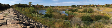
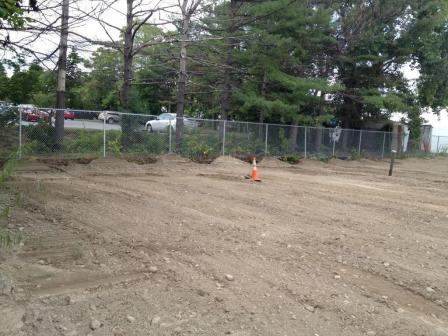
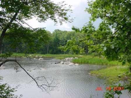
31 Water Street
The half-acre 31 Water Street site is located next to the Back and Powwow rivers in Amesbury, Massachusetts. Several industrial operations in the Lower Millyard area contaminated site soils and surrounding surface waters. The city of Amesbury discovered the contamination during initial revitalization efforts for the historic Amesbury Wharf building area, where the site is located. EPA’s Superfund removal program committed $1.2 million to remove contaminated soil from the site and stabilized the riverbanks. EPA dug up 1,400 tons of contaminated soil and disposed of it off site. EPA also stabilized the riverbanks with 400 feet of sheet pile wall. EPA completed the cleanup actions in July 2015.
Funding from the commonwealth of Massachusetts and EPA facilitated the site’s cleanup and redevelopment. The site, part of the community’s Lower Millyard Project, is now home to Heritage Park. The park provides residents and visitors with a recreation resource next to the Powwow River. Park development included landscaping and planting efforts, and installation of plazas and signs about the area’s history. A bandstand and river walk will soon be added to the park. The Amesbury Riverwalk, a 1.3-mile walking and biking trail, runs next to the site. At a ceremony marking the completion of the Lower Millyard Project, Amesbury’s mayor issued a proclamation thanking EPA for its assistance.
Last updated October 2019
As of December 2019, EPA did not have economic data related to on-site businesses, or economic data were not applicable due to site use. For additional information click here.
For more information:
Atlas Tack Corp.
 Atlas Tack Corp.
The Atlas Tack Corporation Superfund site is located in Fairhaven, Massachusetts. It covers about 48 acres and includes upland areas, wetlands and saltwater marsh. From 1901 to 1985, the Atlas Tack facility made a variety of metal products, including tacks and steel nails, on site. Operations released waste containing acids, metals and solvents into drains and an unlined lagoon near a marsh area. Waste disposal practices resulted in contamination of soil, surface water, sediment and groundwater.
In 1990, EPA placed the site on the National Priorities List (NPL). Cleanup activities included demolition of most remaining site structures, removal of contaminated soil, groundwater monitoring and site restoration. EPA completed these activities in 2007; monitoring began in 2008. Restored wetlands and the saltwater marsh now provide habitat for plants, fish and wildlife. Birders frequent the site for bird-watching activities. These citizen scientists have recorded several species on site, including the Pie-billed Grebe, the American Bittern and the Least Bittern, which are endangered in Massachusetts. Potential future development at the site could include commercial and industrial reuse of upland areas.
Last updated October 2019
As of December 2019, EPA did not have economic data related to on-site businesses, or economic data were not applicable due to site use. For additional information click here.
For more information:
Bendix Property (Former)
 Bendix Property (Former)
The 17.5-acre Former Bendix Property site is located in Greenfield, Massachusetts. A metalworking facility that made drill bits, taps and dies was located on site. A 94,000-square-foot, single-story building sat vacant for about 10 years and deteriorated. Openings in the roof allowed in rain and snow. The rain and snow damaged the heat and water piping, which was wrapped with asbestos-containing insulation wrap. Chromium-containing powder was present in and around the building. EPA removed contaminated materials and devices as well as chromium-containing powder, capacitors and contaminated water. EPA transported these materials to approved facilities. A metal tank and bin production company from Holyoke, Massachusetts, is interested in buying the site property to enlarge its operations.
Last updated October 2019
As of December 2019, EPA did not have economic data related to on-site businesses, or economic data were not applicable due to site use. For additional information click here.
Blackburn & Union Privileges
The Blackburn & Union Privileges Superfund site is located in Walpole, Massachusetts. Industrial and commercial processes on the site using chromium, arsenic, and mercury date back to the 1600s. Between 1891 and 1915, the site was used for manufacture of tires, rubber goods and insulating materials. The crushing of raw asbestos in the manufacture of brake and clutch linings occurred at the site between 1915 and 1937. Various cotton and fabric production processes were conducted at the site from 1937 until 1985, when the facility was abandoned. Industrial operations contaminated soil, sediment and groundwater.
EPA placed the site on the National Priorities List (NPL) in 1994. In 1999, EPA entered into a settlement with parties to perform the remedial investigation and feasibility study. The site’s remedy included excavation, dredging and off-site disposal of contaminated soil and sediment, groundwater treatment and monitoring, and institutional controls. In May 2014, Walpole Town Council approved a plan to acquire the site property. Demolition of the site’s mill building began in September 2014 and cleanup construction began in 2015. A police station opened on site in 2018. In January 2019, a new senior center opened on site. The new senior center houses the veterans’ services office, adult education classes, other community gatherings and recreational opportunities. In December 2018, the site received an EPA Excellence in Site Reuse award. The site also includes residential properties that have been in continuous use throughout cleanup.
Last updated October 2019
As of December 2019, EPA had data on 2 on-site businesses. These businesses employed 55 people and generated an estimated $157,000 in annual sales revenue. For additional information click here.
For more information:
- Blackburn & Union Privileges Superfund Site - Before and After
- Reuse and the Benefit to Community: A Beneficial Effects Economic Case Study for the Blackburn & Union Privileges Superfund Site (PDF)(8 pp, 2.1 MB)
- Superfund Site Profile Page
- Video: EPA Superfund Redevelopment 20th Anniversary
 Charles George Reclamation Trust LandfillCharles-George Reclamation Trust Landfill
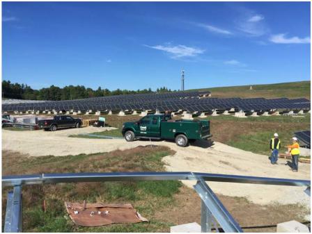
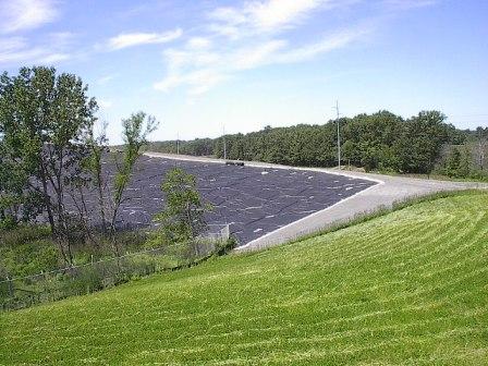
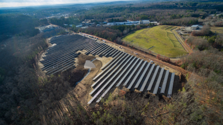
The 70-acre Charles George Reclamation Trust Landfill Superfund site is located in Tyngsborough, Massachusetts. Initially a small municipal dump, the landfill expanded to accept household and industrial wastes, chemicals containing volatile organic compounds and metal sludge. The commonwealth ordered the landfill closed in 1983. Site operations contaminated groundwater.
EPA added the site to the National Priorities List (NPL) in 1983. Cleanup activities provided a permanent water supply to residents affected by contaminated groundwater, capped the landfill, and collect contaminated liquid draining from the landfill (leachate), groundwater and landfill gas. The Massachusetts Department of Environmental Protection operates the landfill gas collection/destruction system and the groundwater/leachate collection system and maintains the cap. In 2017, Citizens Energy Corporation completed construction of a 3.56-megawatt solar photovoltaic facility on the landfill.
Last updated October 2019
As of December 2019, EPA did not have economic data related to on-site businesses, or economic data were not applicable due to site use. For additional information click here.
For more information:
- Site Redevelopment Profile: Charles George Landfill Superfund Site (PDF)(2 pp, 686 K)
- Superfund Site Profile Page
GE - Housatonic River 

The GE-Pittsfield/Housatonic River site includes a 254-acre former manufacturing facility, filled river oxbows, neighboring commercial properties, the Allendale School, Silver Lake, the Housatonic River, floodplains and other areas. The site contains contamination released from the General Electric Company (GE) facility in Pittsfield, Massachusetts. A cleanup decision for portions of the Housatonic River is currently pending. A Consent Decree entered in federal court in 2000 outlined the cleanup of all other areas of the site. Nineteen of 20 cleanup actions outside the river are now complete. EPA expects completion of remaining cleanup actions outside the river in the next two years. Cleanup of 2 miles of the Housatonic River is also complete.
As part of ongoing cleanup activities, the community prioritized the reuse of the former GE facility, located in the heart of downtown Pittsfield. Funded by a Superfund Redevelopment pilot grant from EPA, the Pittsfield Economic Development Authority (PEDA) developed a reuse plan. The plan outlined opportunities for sports fields and an office park. In 2004, GE built a 3-acre recreational facility on site for the community. The facility includes a baseball diamond, soccer field, jogging track, equipment storage, fencing and lighting. Between 2005 and 2012, PEDA received ownership of 50 acres at the site for the development of the William Stanley Business Park. The facility provides commercial and industrial space for area businesses. The park’s first tenant, a financial services company, built a 170,000-square-foot building that opened in 2012. Western Massachusetts Electric Company installed an 8-acre solar power facility in 2010, using 2 acres of the site and 6 acres of an adjacent property, which generates 1.8-megawatts of electricity. In 2014, PEDA received a $9 million state grant to design and build the Berkshire Innovation Center (BIC). Construction of the BIC facility is expected to be complete in the fall of 2019. The facility will support shared research, early-stage production and commercialization, and work force training for life science companies and related businesses. Two large employers continue to operate on the GE-owned portion of the 254-acre facility. Continued uses on the non-GE owned portion of the site (excluding the Rest of River) include an elementary school, about 86 residential properties, about 35 commercial properties and a city park.
Last updated October 2019
As of December 2019, EPA had data on 40 on-site businesses. These businesses employed 1,942 people and generated an estimated $70,684,396 in annual sales revenue. For additional information click here.
For more information:
Groveland Wells
The 850-acre Groveland Wells Superfund site is located in Groveland, Essex County, Massachusetts. The former Valley Manufacturing Products Company produced metal and plastic parts on site until 2002. The site's potentially responsible parties (PRPs) released cutting oils and chlorinated hazardous solvents on site. Additional waste leaked from storage tanks and disposal systems at the facility. Site releases contaminated the town of Groveland’s public water supply.
EPA placed the site on the National Priorities List (NPL) in 1982. In late 1987 and early 1988, the PRPs installed and used soil vapor extraction (SVE) to remove contaminants from site soils. The PRPs also installed a small groundwater treatment system in 1988. However, these systems were ineffective. EPA then designed and installed a large groundwater treatment system in 2000. In 2006, EPA removed abandoned underground storage tanks, a former disposal system and contaminated soils from the site. From 2009 to 2011, EPA designed, installed and operated an electrical resistive heating treatment system to replace the SVE system. Treatment activities were effective and concluded in 2014.
The Groveland Department of Public Works continues to operate on site. In 2012, a regional energy company installed a 3.6-megawatt solar array on site. It provides power for more than 500 homes. The site remains in continued residential, commercial and industrial use. EPA continues to monitor conditions, conducting a review of the cleanup actions every five years to make sure the remedy remains protective of human health and the environment.
Last updated October 2019
As of December 2019, EPA did not have economic data related to on-site businesses, or economic data were not applicable due to site use. For additional information click here.
For more information:
Hatheway & Patterson 
 Hatheway & PattersonThe 38-acre Hatheway & Patterson Superfund site is located in Mansfield and Foxborough, Massachusetts. The site includes the area where the Hatheway and Patterson Company operated a wood-preserving facility from 1953 to 1993. Releases of chemicals resulted in soil and groundwater contamination. Releases also contaminated sediment and surface water in the Rumford River’s fisheries and surrounding wetlands.
EPA placed the site on the National Priorities List (NPL) in 2002. Cleanup included removal of contaminated soil, capping of a 2-acre area, institutional controls, and long-term monitoring of groundwater, surface water, fish tissue and sediment. EPA completed the cleanup in 2011. EPA deleted the site from the NPL in 2018. In 2010, a 119-space commuter parking lot was built on part of the site. The lot serves the nearby Mansfield commuter rail station. The town of Mansfield uses part of the site for emergency vehicle storage and uses a site building for office space. The Mansfield portion of the site along County Street in not currently in use.
Last updated October 2019
As of December 2019, EPA did not have economic data related to on-site businesses, or economic data were not applicable due to site use. For additional information click here.
For more information:
Industri-Plex
 Industri-Plex
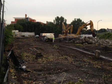
The Industri-Plex Superfund site in Woburn, Massachusetts, is located 12 miles outside of Boston. From 1853 to 1969, several manufacturers produced chemicals, insecticides, munitions and glue products at the site. Large waste piles, heavy metals and hazardous chemicals collected on site. This waste resulted in groundwater, surface water, soil and sediment contamination.
In 1983, EPA placed the site on the National Priorities List (NPL). Cleanup included placement of protective covers over contaminated parts of the site, dredging and off-site disposal of contaminated sediments, construction of wetlands, and institutional controls. The covers were compatible with productive reuse of the areas.
During and after initial cleanup activities, several public- and private-sector improvements took place. They included a new interstate highway exchange, public roads, a 200,000-square-foot shopping center, an office park and a hotel complex. Restored wetlands and grass-covered hills provide scenic open space at the site. The site’s successful redevelopment was recognized by the prestigious Phoenix Award in 2000. In 2001, the 34-acre, $10 million James Anderson Regional Transportation Center opened at the site. The center relieves congestion on highways leading into Boston and eases commutes for many area residents. In 2008 and 2009, additional redevelopment included a restaurant, a pet supply store and a furniture store. EPA, the state and local government worked with the developer to record property use restrictions, prepare work plans, remove a building and support the property’s transformation. An additional phase of cleanup will be completed in 2017. Mitigation projects along the Aberjona River include floodplain enhancements and the Aberjona Nature Trail as well as a fish ladder at the Center Falls Dam in nearby Winchester. EPA continues to support the safe redevelopment of properties at the site, and prepared a 2018 Explanation of Significant Differences that enabled two mixed-use and residential projects to move forward. Construction of a 200-unit apartment community began in 2018 and was expected to be completed in 2019. In addition, construction of a 289-unit luxury multi-family housing and over 9,000 square feet of commercial space development began in 2019.
Last updated July 2020
As of December 2019, EPA had data on 53 on-site businesses. These businesses employed 1,026 people and generated an estimated $241,170,620 in annual sales revenue. For additional information click here.
For more information:
- Reuse and the Benefit to Community: Industri-Plex Case Study (2014) (PDF) (21 pp, 1.6 MB, About PDF)
- Superfund Site Profile Page
Intervale Street
 Intervale StreetThe 0.75-acre Intervale site is located in Quincy, Massachusetts. A metals recycling business operated on site. Sampling in 2012 detected polychlorinated biphenyls, lead, arsenic and chromium in site soils. EPA removed about 4,400 tons of contaminated soil in 2014 and 2015. The city of Quincy will offer the site property for sale after completion of EPA’s cleanup activities.
Last updated October 2019
As of December 2019, EPA did not have economic data related to on-site businesses, or economic data were not applicable due to site use. For additional information click here.
For more information:
Iron Horse Park
 Iron Horse ParkThe Iron Horse Park Superfund site is a 553-acre industrial complex in Billerica, Massachusetts. Beginning in 1913, on-site industrial activities included manufacturing, rail yard maintenance, waste storage and landfilling. These operations resulted in soil, groundwater and surface water contamination.
EPA added the site to the National Priorities List (NPL) in 1984. Cleanup activities are ongoing. They have included removing contaminated soil, backfilling areas with clean soil, capping contaminated soil areas, and closing and capping landfills. These activities supported the continued operation of industrial businesses on site, including lumber, manufacturing and rail yard maintenance facilities. Cleanup also restored natural marshes and new wetland habitats. In 2012, site stakeholders began a project to place solar panels on the Shaffer Landfill, a former waste disposal area. After coordinating with EPA and the state, the town of Billerica signed a payment in lieu of taxes (PILOT) agreement in August 2013. The agreement guarantees project revenue over 25 years.
With the agreement in place, construction of the 25-acre solar array began in early 2014. Urban Green Technologies (UGT), the solar developer, placed 20,000 solar panels over the capped landfill. EPA worked with UGT to address the challenge of installing solar panels on the sloped landfill while ensuring its cap remained intact. In August 2014, EPA, the Massachusetts Department of Environmental Protection, UGT and the town of Billerica held a ceremony marking the project’s completion. In December 2014, EPA awarded its first-ever Superfund Excellence in Site Reuse award to the project team for the innovative solar project. Since then, a 4-megawatt solar array was constructed on site, followed by a 6-megawatt array in 2017. In total, the site produces 16 megawatts of electricity. The solar facilities allow the town of Billerica to reduce its dependence on fossil fuels and benefit from significant long-term energy cost savings.
Last updated October 2019
As of December 2019, EPA had data on 8 on-site businesses. These businesses employed 358 people and generated an estimated $57,709,545 in annual sales revenue. For additional information click here.
For more information:
- Reuse and the Benefit to Community: Iron Horse Park Superfund Site (PDF)(9 pp, 2 MB)
- Site Redevelopment Profile for the Iron Horse Park Superfund Site (PDF)(3 pp, 1.7 MB)
- EPA Issues First "Re-use" Awards for New England Superfund Sites
- Superfund Site Profile Page
King Philip Mills
The King Philip Mills site is located in Fall River, Massachusetts. A cotton mill was built on site between 1871 and 1892. EPA identified drums, containers and cylinders at the site. In November 2014, EPA completed a time-critical removal action to remove contaminated drums and containers as well as asbestos-containing material. EPA completed a second time-critical removal action in March 2017 to remove polychlorinated biphenyl oils from contaminated materials. In January 2018, a developer bought the site property at auction. The owner is demolishing some structures and redeveloping the area into 26 single-family market-rate homes along Cook Pond. The developer also plans to reuse one of the remaining structures as a mixed-use building. Part of the property will be set aside as open space, making it the first time in 100 years that the South End neighborhood will have access to Cook Pond.
Last updated October 2019
As of December 2019, EPA did not have economic data related to on-site businesses, or economic data were not applicable due to site use. For additional information click here.
For more information:
Lawrence Metals (Former)
 Lawrence Metals (Former)The Former Lawrence Metals site is located in Chelsea, Massachusetts. From the late nineteenth century until 1974, when a fire destroyed the building, owner operators used the site property for textile production, barrel cleaning and painting. From 1979 to 1986, operators used the property for warehouse space. In 1986, the Lawrence Metals Forming Company began operating on site. Its operations resulted in the contamination of soil and site materials. In 1999, the city of Chelsea (the City) acquired the site property under an Urban Renewal Plan. The City demolished the site building in 2000. EPA, the City and state agencies coordinated cleanup, including the excavation of contaminated soil. The project was particularly challenging because of its proximity to a school and a city swimming pool. An upscale, extended-stay hotel is now located on site.
Last updated October 2019
As of December 2019, EPA had data on one on-site business. This business employed 25 people and generated an estimated $150,000 in annual sales revenue. For additional information click here.
For more information:
New Bedford
The 18,000-acre New Bedford Harbor Superfund site is located in New Bedford, Massachusetts. At least two companies produced capacitors and other electronics containing polychlorinated biphenyls on site from 1940 to the late 1970s. Operations discharged industrial wastes into the harbor, which contaminated the estuary from the upper Acushnet River into Buzzards Bay.
In 1983, EPA placed the site on the National Priorities List (NPL). Ongoing cleanup activities include the removal and disposal of contaminated sediments at approved off-site facilities, and within confined aquatic disposal cells in the harbor. Cleanup plans also include removal of contaminated sediment and wetland restoration at shoreline properties. Dredging has taken place at the site on a continuous basis since 2004.
The city of New Bedford (the City) plans to reuse EPA’s shoreline sediment dewatering facility as an intermodal transportation facility. The facility, located on the City’s working waterfront, will include berthing space for freighters and commercial fishing vessels, a 55,000-square-foot warehouse, and a rail spur that connects to the City’s rail yard. In 2011, EPA completed demolition of the 11-acre Aerovox mill, located along the Acushnet River. The area will provide the City with space for potential future redevelopment. Residents use the harbor for recreational activities such as rowing.
Additionally, the cleanup plan allows for additional dredging efforts by local and state stakeholders. Dredging of the harbor, which enhances the remedy by removing sediment not addressed by the Superfund cleanup, has resulted in private investment to the commercial port. It paved the way for recent construction of the New Bedford Marine Commerce Terminal, a 28-acre marine terminal designed to support development of off-shore wind energy. Redevelopment along the river is ongoing. Projects include the repurposing of former mills for apartments and commercial space. Finally, plans include a riverwalk along the Upper Harbor and habitat restoration, which will draw residents back to the waterfront for recreational activities. EPA’s cleanup will address contamination along the shoreline prior to construction of the Riverwalk. Completion of the cleanup will allow for further redevelopment and repurposing of buildings along the shoreline. EPA’s subtidal sediment dredging at New Bedford Harbor will be complete in 2019. In 2020, EPA’s contaminated sediment dewatering plant will be decontaminated and turned over to the City for commercial reuse as a multi-modal marine terminal.
With EPA’s mission to protect human health and the environment in mind, EPA established the Superfund Task Force in May 2017 to provide recommendations for improving and expediting site cleanups and promoting redevelopment. Based on the Superfund Task Force recommendations, EPA identified the site as a Redevelopment Opportunity site – a site with the greatest expected redevelopment potential.
Last updated October 2019
As of December 2019, EPA did not have economic data related to on-site businesses, or economic data were not applicable due to site use. For additional information click here.
For more information:
Norwood PCBs 
 Norwood PCBsThe 26-acre Norwood PCBs Superfund site is located in Norwood, Massachusetts. From 1942 through the mid-1980s, several businesses made and maintained electrical components on site. During site investigations, EPA found polychlorinated biphenyls in soil and groundwater on site and in the sediment of a nearby brook.
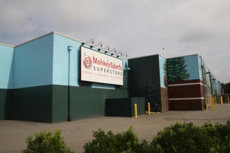
In 1986, EPA placed the site on the National Priorities List (NPL). Cleanup included removing contaminated soil and sediment and consolidating it under an asphalt cap. It also included demolition of on-site structures and long-term monitoring. A groundwater treatment facility operated on site until 2001. In 2008, the site owner and developers completed a 56,000-square-foot commercial retail facility on site. Developers located new buildings next to the capped area. They increased the thickness of the asphalt cap remedy to allow for its use as a parking lot. An athletic goods store and a fitness gym are currently located in the facility. On a 16-acre portion of the site in a development known as Kerry Place, commercial and light industrial businesses have continued to operate since 1979. EPA took the site off the NPL in 2011.
Last updated October 2019
As of December 2019, EPA had data on 23 on-site businesses. These businesses employed 306 people and generated an estimated $44,006,447 in annual sales revenue. For additional information click here.
For more information:
Nyanza Chemical Waste Dump 
 Nyanza Chemical Waste Dump
The 35-acre Nyanza Chemical Waste Dump Superfund site is located in Ashland, Massachusetts. From 1917 to 1978, companies made textile dyes, dye intermediates and other products at the site. Operators buried solid waste on site. They also released wastewater into a system of lagoons and storage areas that were periodically drained; the solid material was excavated and placed on a hill. Overland flow from the hill resulted in the contamination of nearby wetlands and surface water bodies, including the Eastern Wetland and the Sudbury River. These improper waste-handling practices also resulted in groundwater, soil and sediment contamination.
EPA placed the site on the National Priorities List (NPL) in 1983. In the mid-1990s, indoor air samples from residences near the site and above a contaminated groundwater plume found potentially unsafe levels of volatile chemicals in indoor air. Cleanup activities included removing sludge and contaminated soils and sediments, placing a cap over contaminated soils, and installing systems to stop vapors from coming into homes. Cleanup also included extensive wetland restoration. Sediment and fish tissue monitoring for heavy metals has also been conducted in impacted reaches of the Sudbury River, and fish consumption advisories have been posted. While cleanup decisions have been made for most of the site, EPA is in the process of selecting the final groundwater remedy. Several businesses, including Nyacol Nano Technologies continue to operate at the site.
Last updated July 2020
As of December 2019, EPA had data on 7 on-site businesses. These businesses employed 43 people and generated an estimated $9,848,403 in annual sales revenue. additional information click here.
For more information:
Parsons Paper Mill
 Parsons Paper MillThe 4.6-acre Parsons Paper site is located in Holyoke, Massachusetts. From 1896 to 2004, operators made writing and stationary paper as well as artist paper and archival paper for the art and framing industries on site. In 2008, a fire destroyed about 50% of the mill. The fire also damaged remaining parts of the interconnected building complex. In 2009, EPA sampling identified asbestos in the burned areas. Sources of asbestos includes asphalt shingles, window glazing and caulking, tank and pipe insulation, transite siding, cements and mastics, and floor tiles. In 2009 and 2010, EPA removed hazardous materials and asbestos that posed a threat to public health. In 2016, building demolition began on site for the expansion of Holyoke manufacturer Aegis Energy Services.
Last updated October 2019
As of December 2019, EPA did not have economic data related to on-site businesses, or economic data were not applicable due to site use. For additional information click here.
For more information:
Peabody Street Asbestos
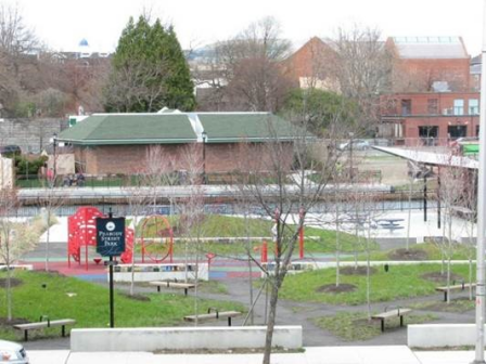 Peabody Street AsbestosThe Peabody Street Asbestos site is located in Salem, Massachusetts. The city of Salem identified asbestos during construction of a park in the downtown area. EPA excavated contaminated soil because of the urban setting and because the city and state did not have funds for the excavation. EPA recovered most expenses from the polluter. The city resumed construction of the park after EPA completed the excavation. Completed in 2010, the Peabody Street Park/Harbor walk serves as a gateway to Salem’s harbor. The park includes a playground, a canopy area, and seating for outdoor entertainment as well as game tables, benches and landscaping.
Last updated October 2019
As of December 2019, EPA did not have economic data related to on-site businesses, or economic data were not applicable due to site use. For additional information click here.
For more information:
PSC Resources
The 4-acre PSC Resources Superfund site is located in Palmer, Massachusetts. From 1974 to 1978, waste oil and solvent recovery and disposal resulted in spills. These spills contaminated soils, sediments and groundwater. EPA placed the site on the National Priorities List (NPL) in 1983. EPA dug up contaminated soils and sediment, treated them, and put them under an impermeable cap. EPA vegetated the cap. EPA also placed a fence around the capped material to prevent access. A Mobil Oil Company pipeline runs along a corridor south of the site. The site includes forest and wetland areas that are used by local residents for recreation activities.
Last updated October 2019
As of December 2019, EPA did not have economic data related to on-site businesses, or economic data were not applicable due to site use. For additional information click here.
For more information:
Re-Solve, Inc.
The 6-acre Re-Solve, Inc. Superfund site is a former waste chemical reclamation facility in North Dartmouth, Massachusetts. Between 1956 and 1980, site operators disposed of residues from operations, liquid sludge waste, impure solvents and burned tires in on-site unlined lagoons. Site operators also spread oil waste over the site to control dust.
EPA placed the site on the National Priorities List (NPL) in 1983. EPA and the site’s potentially responsible parties (PRPs) constructed a groundwater pump-and-treat system at the site. The system has operated continuously since 1998. As part of the cleanup, EPA and the PRPs restored 1 acre of wetlands at the site. The PRPs also worked closely with EPA and the U.S. Fish & Wildlife Service to convert 4 acres of the site into a native meadow for ecological reuse. To enhance the meadow habitat, the PRPs placed bird boxes, brush piles and sand piles for turtles. An annual fishing derby at Cornell Pond on site engages the community in fish monitoring activities. EPA and the PRPs have also collaboratively evaluated sustainable treatment enhancements for the groundwater treatment system since 2004. In 2015, two anaerobic bio-reactor systems were located on site. The systems are underground, contained biological treatment beds where living organisms break down contamination. This process reduces the use of chemicals and the need for waste disposal. The groundwater treatment system is powered entirely by 644 solar panels.
Last updated October 2019
As of December 2019, EPA did not have economic data related to on-site businesses, or economic data were not applicable due to site use. For additional information click here.
For more information:
- Site Redevelopment Profile for the Re-Solve, Inc. Superfund Site (PDF)(2 pp, 755 K)
- Superfund Site Profile Page
Sullivan's Ledge
 Sullivan's LedgeThe Sullivan’s Ledge Superfund site is located in New Bedford, Massachusetts. A 12-acre quarry operated on site until 1921. In 1935, the city of New Bedford (the City) took over the site and turned it into a dump for hazardous materials. Waste disposal activities took place on site from the 1940s through the 1970s. The City then closed the dump and backfilled the disposal areas. In 1982, during investigations associated with a proposed parking lot development, the Massachusetts Department of Public Works, now the Massachusetts Highway Department, found soil contamination at the site.
EPA conducted studies in the area and placed the site on the National Priorities List (NPL) in 1984. Cleanup activities included removing contaminated soil and sediment and capping the site. Cleanup also included removing contamination from a neighboring golf course. EPA’s approach allowed for continued use of the golf course during cleanup. EPA also restored 13 acres of affected wetlands. Restoration work finished in 2002. Today, the wetlands provide habitat for many wildlife species, including the great blue heron, great egret, red-tailed hawk and spotted turtle. In 2013, EPA approved the installation of a 1.75-megawatt solar project on the capped part of the site. Project partners SunEdison, Beaumont Solar, Pro-Tech Energy Solutions and BlueWave Capital completed construction in 2014. The 10-acre system includes more than 5,000 solar panels. A partnership between BlueWave Capital and the City is supporting further solar projects around New Bedford. The City buys energy generated from the solar arrays. This enables the City to increase its use of renewable energy sources and save 30% on municipal electricity bills. Over the course of 20 years, New Bedford will save about $2.7 million in energy costs through the purchase of solar net metering credits. In 2014, EPA recognized the project team, including the City, BlueWave Capital and SunEdison, with Region 1’s first Excellence in Site Reuse Award.
Last updated October 2019
As of December 2019, EPA had data on 2 on-site businesses. EPA did not have further economic details related to these businesses. For additional information click here.
For more information:
- Utility-Scale Solar Energy Development: The Sullivan's Ledge Superfund Site in New Bedford, Massachusetts (PDF)(14 pp, 3.5 MB, About PDF)
- EPA Issues First "Re-use" Awards for New England Superfund Sites
- Superfund Site Profile Page
Sutton Brook Disposal Area
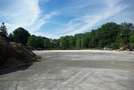
The 50-acre Sutton Brook Disposal Area Superfund site is located in Tewksbury, Massachusetts. From 1957 until 1988, a landfill operated on site, accepting municipal, commercial and industrial wastes. Waste disposal practices led to soil, sediment, surface water, groundwater and air contamination. In 1983, the Massachusetts Department of Environmental Protection inspected the landfill and took water samples from a nearby brook. The samples contained organic contaminants.
EPA placed the site on the National Priorities List (NPL) in July 2000. EPA performed three short-term cleanups on and near the site. During these, EPA excavated and removed highly contaminated soils and drums. The site’s long-term remedy included excavating additional soils and sediments, consolidating this material in on-site landfills, landfill capping, and wetlands restoration. It also included groundwater collection and treatment, monitored natural attenuation for groundwater outside the extraction system area, institutional controls and long-term monitoring. Cleanup finished in July 2016. The site now includes restored wetlands, providing habitat for local plants and animals.
Last updated October 2019
As of December 2019, EPA did not have economic data related to on-site businesses, or economic data were not applicable due to site use. For additional information click here.
For more information:
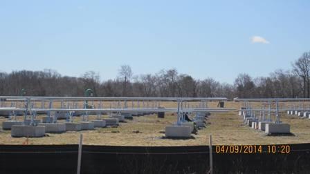
W.R. Grace & Co., Inc. (Acton Plant)
 W.R. Grace & Co., Inc. (Acton Plant)The 260-acre W.R. Grace & Co., Inc. (Action Plant) Superfund site is located in the towns of Acton and Concord, Massachusetts. For over 100 years, different companies operated a chemical manufacturing facility on site. W.R. Grace, the last site owner, ceased all operations in 1991. Facility operators created wastewater and solid industrial wastes and disposed of them in several unlined lagoons and an on-site landfill. These practices contaminated soils, groundwater, surface water and sediments. In 1978, investigations found contamination in two municipal wells in Acton. EPA directed W.R. Grace to begin interim cleanup actions at the site.
EPA placed the site on the National Priorities List (NPL) in September 1983. Interim cleanup actions included groundwater extraction and treatment and removal of hazardous storage tanks. Final cleanup actions included landfill and lagoon closure, capping of site soils and sludges, sediment dredging and removal, additional groundwater extraction and treatment, and restoration of site wetlands. After the site’s remedy was in place, the town of Concord took ownership of a 70-acre parcel at the site in 2016. The first phase of the town’s three-phase reuse plan involved construction of a 4.5-megawatt solar array, which was completed in early 2017. This project added more green, competitively priced energy to the town's power supply portfolio.
It is expected to supply 4.5% of the town's power supply needs, enough to power 625 homes. Additionally, the solar array will reduce greenhouse gas emissions and offset the town's peak demand for electricity by 10%. Planning for remaining reuse phases – for a school bus depot and a wastewater treatment facility – is underway.
Last updated October 2019
As of December 2019, EPA had data on 3 on-site businesses. These businesses employed 13 people and generated an estimated $5,371,000 in annual sales revenue. For additional information click here.
For more information:
- Redevelopment of the W.R. Grace & Co., Inc. (Acton Plant) Superfund Site (PDF)(2 pp, 1.5 MB)
- Superfund Site Profile Page
Wells G&H
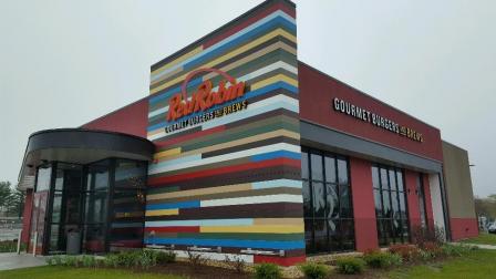 Wells G&HThe Wells G & H Superfund site includes 330 acres of land and contaminated groundwater in Woburn, Massachusetts. Past operations at the site include dry cleaning, solvent storage, truck terminals, drum disposal and plastics manufacturing. In 1979, the Massachusetts Department of Environmental Protection (MassDEP) discovered significant levels of hazardous chemicals in two municipal supply wells. These wells were known as wells G and H. MassDEP closed the wells. EPA placed the site on the National Priorities List (NPL) in 1983. Cleanup activities included removing debris and contaminated soils and treating contaminated soils on site. Cleanup also included groundwater removal and treatment. Cleanup activities are still ongoing across the site.
In 2000, EPA awarded the Woburn city government a grant to complete a comprehensive Land Use Plan for the site. Three of the site’s responsible parties contributed additional funding for the effort. In 2002, the city of Woburn’s Redevelopment Authority began exploring reuse options for the site. The Land Use Plan identified reuse scenarios for three priority site areas: the Aberjona Auto Parts property, the city of Woburn property and the W.R. Grace property. The reuse scenario for the Aberjona Auto Parts property focused on an ice arena for local hockey leagues. Construction of Holland Arena finished in 2008. The property owner also leases parts of the property to small businesses. The Land Use Plan identified public open space and passive recreation as priority future uses for the city of Woburn property. In July 2017, the Aberjona Nature Trail officially opened along the Aberjona River. The trail provides recreation and wildlife viewing opportunities. The Land Use Plan identified commercial land uses as the priority for the W.R. Grace property. In 2014, the property was purchased by Madison Woburn Holdings LLC for the development of a hotel and three restaurants. A Red Robin Gourmet Burgers and Brews opened in 2016; and a 110 Grill and Chick-Fil-A opened in 2019. Construction of a Homewood Suites and Hampton Inn hotel is expected to be completed in 2019. The site also includes residential buildings.
Last updated October 2019
As of December 2019, EPA had data on 360 on-site businesses. These businesses employed 3,595 people and generated an estimated $644,281,828 in annual sales revenue. For additional information click here.
For more information: