Superfund Sites in Reuse in New Hampshire
If you are having trouble viewing the map in your browser, click the 'View larger map' link below
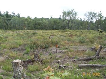
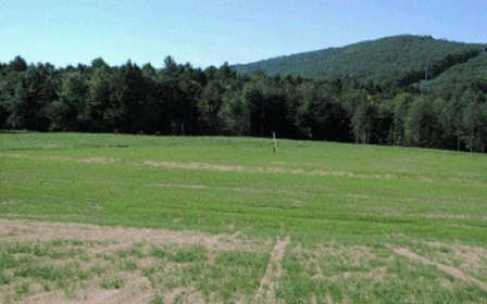
Auburn Road Landfill 
 Auburn Road LandfillThe 200-acre Auburn Road Landfill Superfund site is located in Londonderry, New Hampshire. The site includes three separate disposal areas that cover about 12 acres. A disposal area for chemical wastes, tires, demolition debris and solid waste operated on site from the 1960s to 1980. The state of New Hampshire found contamination in soil, groundwater and surface water and ordered the landfill’s closure in 1980.
EPA placed the site on the National Priorities List (NPL) in 1983. Cleanup activities included capping and fencing of contaminated areas as well as extension of the public water supply to nearby residents. Groundwater sampling is ongoing. Parts of the site are now in recreational and residential reuse. A model airplane flying field opened on site in 2008. This recreational reuse was the result of collaboration among EPA, the New Hampshire Flying Tigers Academy of Model Aeronautics and the town of Londonderry. Part of the Whispering Pines Mobile Home Park is located on the northern part of the site.
Last updated October 2019
As of December 2019, EPA did not have economic data related to on-site businesses, or economic data were not applicable due to site use. For additional information click here.
For more information:
Fletcher's Paint Works & Storage 
The Fletcher’s Paint Works & Storage Superfund site is located in Milford, New Hampshire. A paint manufacturing plant and retail outlet operated on site from 1949 to 1991. In 1982, the New Hampshire Department of Environmental Services (NHDES) inspected the facility. NHDES found leaking and open drums on site. NHDES also found site-related contamination in the Keyes Municipal Water Supply Well next to the site.
EPA placed the 2-acre area on the National Priorities List (NPL) in 1989. Past cleanup efforts include building demolition, drum removal, fencing, temporary cover installation, removal of contaminated soil from residential properties, and placement of a temporary liner and gravel cover over highly contaminated areas. In 1996, at the request of the town of Milford, the potentially responsible party removed soil with low levels of contamination from the Elm Street Area of the site. This soil removal allowed for construction of a Korean War Memorial. In 2017, construction activities were completed. These activities included the Mill Street Area soil excavation, backfilling of the area with clean soil and a grass cover, and temporary alternate access to Keyes Recreational Field for better local traffic management in the area. Construction activities at the Elm Street Area included soil excavation, an engineered soils and grass cover permitting recreational use, and an asphalt cover over select areas providing the town with additional parking for nearby Keyes Recreational Field. Groundwater monitoring is ongoing.
Last updated October 2019
For more information:
Kearsarge Metallurgical Corp.
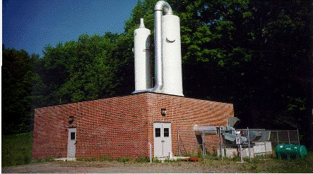
 Kearsage Metallurgical Corp.The 9-acre Kearsarge Metallurgical Corporation (KMC) Superfund site is located in Conway, New Hampshire, on the north shore of Pequawket Pond. From about the mid-1960s through the early 1980s, KMC made stainless steel castings on site. The manufacturing process created waste casting sands, wax and solvents. KMC dumped these wastes in a wooded wetland east of the facility. When operations ceased, the New Hampshire Department of Environmental Services (NHDES) and EPA found a waste pile, soils and groundwater contaminated with solvents.
EPA placed the site on the National Priorities List (NPL) in 1984. Cleanup began in 1992. Cleanup included removal of 13,620 tons of contaminated soils and construction of a groundwater treatment plant. During 12 years of operation, the plant treated over 250 million gallons of water and removed more than 225 pounds of contaminants. In 2012, the town sold the site property at auction to help invigorate the surrounding industrial park. EPA and NHDES addressed remaining groundwater contamination with a soil treatment remedy in 2015. A towing company, a heating business, and a farm equipment and diesel truck repair facility are currently located in the former groundwater treatment plant and part of the original KMC building. Ecological reuse includes forested wetlands that provide ecological habitat along the northern bank of Pequawket Pond.
Last updated October 2019
As of December 2019, EPA had data on 3 on-site businesses. These businesses employed 8 people and generated an estimated $636,000 in annual sales revenue. For additional information click here.
For more information:
- Site Redevelopment Profile for the Kearsarge Metallurgical Corp. Superfund Site (PDF)(3 pp, 1.8 MB, About PDF)
- Reuse and the Benefit to Community: Kearsarge Metallurgical Corp. Superfund Site (PDF)(9 pp, 2 MB)
- Superfund Site Profile Page
Ottati & Goss/Kingston Steel Drum
 Ottati & Goss/Kingston Steel DrumThe 35-acre Ottati & Goss/Kingston Steel Drum Superfund site is located in Kingston, New Hampshire. The site includes a 6-acre parcel, known as the Great Lakes Corporation area, and a 1-acre parcel, known as the Ottati & Goss area. From the late 1950s through 1980, various owners reconditioned steel drums on the Great Lakes Corporation area. Runoff and seepage from this area into nearby surface water killed fish and aquatic vegetation. From 1978 through 1979, site operators processed waste at the Ottati & Goss area. Activities contaminated soil, groundwater and surface water. After operations ended in 1979, the New Hampshire Bureau of Solid Waste Management prohibited site operators from restarting operations. The Bureau ordered the removal of thousands of deteriorating and leaking drums from the site.
EPA placed the site on the National Priorities List (NPL) in 1983. Cleanup activities included removal of leaking drums and thousands of tons of soil and debris, excavation and on-site treatment of soil and sediment using thermal desorption, groundwater and soil treatment using in-place chemical oxidation, and wetland restoration for ecological reuse. Wetland restoration included the placement of over 20,000 cubic yards of manufactured wetland material and the planting of more than 1,000 trees and shrubs.
Last updated October 2019
As of December 2019, EPA did not have economic data related to on-site businesses, or economic data were not applicable due to site use. For additional information click here.
For more information:
Somersworth Sanitary Landfill
The 26-acre Somersworth Sanitary Landfill Superfund site is located in Somersworth, New Hampshire. The city of Somersworth (the City) operated a waste disposal area at the site from the mid-1930s until 1981. The City burned residential, commercial and industrial wastes at the site. In 1958, the City stopped burning waste and converted the area into a landfill. Improper disposal practices contaminated site soil, sediment and groundwater.
EPA added the site to the National Priorities List (NPL) in 1983. Cleanup included groundwater containment and treatment, a landfill cover and gas venting. Cleanup also included land and groundwater use restrictions. Before the site’s listing on the NPL, the City covered a 10-acre portion of the site with clean fill for use as a recreation area. This area now includes a basketball court. Part of the site remains wetlands. In 2013, EPA presented the City with an initial assessment of renewable energy opportunities for the site. Currently, no renewable energy projects are planned for the site.
Last updated February 2020
As of December 2019, EPA did not have economic data related to on-site businesses, or economic data were not applicable due to site use. For additional information click here.
For more information:
South Municipal Water Supply Well 
 South Municipal Water Supply WellThe 250-acre South Municipal Water Supply Well Superfund site is located in the Contoocook River Valley in Peterborough, New Hampshire. Installed in 1952, the South Municipal Water Supply Well provided water to Peterborough for nearly 30 years. In 1982, testing by the state of New Hampshire revealed contaminants in the water and the well was closed. Investigations found that the nearby New Hampshire Ball Bearings facility was the source of the contamination. The facility has manufactured precision ball bearings since 1956. Activities at the facility contaminated soil, groundwater, wetland sediments and surface water.
EPA placed the site on the National Priorities List (NPL) in 1984. Initial cleanup activities included groundwater and soil treatment, off-site disposal of contaminated sediments, and wetland restoration. Later, EPA determined that restoration of some contaminated groundwater at the site was not possible. EPA updated the remedy to contain the groundwater instead of treating it. In 2008, EPA found that the site remedy was not functioning as intended. EPA updated the cleanup plan in 2010 to change source control and migration management activities. New Hampshire Ball Bearings completed a below-ground wall to clean up contaminated groundwater in 2014. In-place thermal treatment of an on-site source area finished in 2016. Current site uses include the 24-acre active New Hampshire Ball Bearings manufacturing plant, commercial and residential properties, part of U.S. Route 202, and wetlands.
Last updated October 2019
As of December 2019, EPA had data on 2 on-site businesses. These businesses employed 559 people and generated an estimated $85,558,824 in annual sales revenue. For additional information click here.
For more information:
Synergy (Former)
 Synergy (Former)The Former Synergy Site is located in Claremont, New Hampshire. From the turn of the century until the mid-1940s, a manufactured gas plant operated on site. Operations contaminated soil with coal tar, a common contaminant of that process. Between 2010 and 2012, investigations identified waste perched on bedrock that was leaching into the Sugar River. Cleanup activities included removing structures and soil, stabilization, and capping. Because of the historical importance of the gas plant to the town’s textile history and EPA’s obligations under the Historical Preservation Act, EPA coordinated with the State Historic Preservation Office during cleanup activities. A brick-and-concrete structure with informative plaques now memorializes the site’s history. The site is located near a visitor's center and is part of the community’s historic downtown area. The site is currently a picturesque open space on the banks of the Sugar River. Looking forward, the town will consider reuse options for the property.
Last updated October 2019
As of December 2019, EPA did not have economic data related to on-site businesses, or economic data were not applicable due to site use. For additional information click here.
For more information:
Tinkham Garage
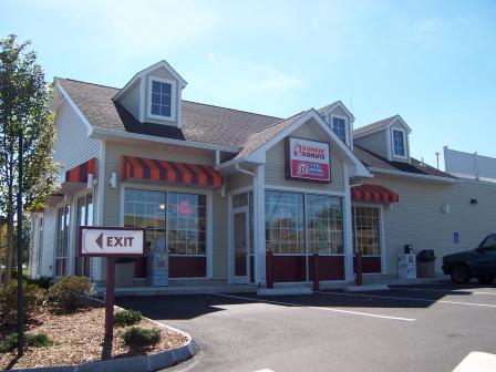 Tinkham GarageThe 375-acre Tinkham Garage Superfund site is located in Londonderry, New Hampshire. On one end of the site, solvents and other hazardous substances were discharged behind a garage during the late 1970s. On another part of the site, petroleum, solvents and wash waters were discharged into the leach fields of the Woodland Village Condominium complex. In 1978, residents complained of foam and odors in a small unnamed stream that runs through the complex. Investigators found soil and groundwater contamination.
In 1983, EPA placed the site on the National Priorities List (NPL). Cleanup activities included groundwater and soil treatment, and extension of the public water line to the condominium complex and nearby houses. Cleanup also included new sewer lines and groundwater monitoring. Groundwater monitoring, additional water line extensions to residents, and additional source area and bedrock investigations are ongoing. During cleanup, EPA provided information to interested parties about reuse considerations for the site.
Today, a shopping complex with a Home Depot, Staples and Dunkin’ Donuts occupies the northeast area of the site. The Woodland Village Condominium complex and several single-family homes remain on the northern part of the site. The Nevins Retirement Cooperative Association completed construction of over 125 residences on the central part of the site. These residences are part of a senior housing development. Site redevelopment has increased property values in Londonderry. Increased economic activity at the site has also encouraged local infrastructure improvements.
Last updated October 2019
As of December 2019, EPA had data on 7 on-site businesses. These businesses employed 245 people and generated an estimated $92,186,000 in annual sales revenue. For additional information click here.
For more information:
Town Garage/Radio Beacon
The Town Garage/Radio Beacon Superfund site is located in Londonderry, New Hampshire. The U.S. Department of Defense (DOD) owned part of the site from the early 1940s until 1968. DOD operated a radio beacon there during World War II. Afterwards, the site contained a series of residential wells and one commercial well. A 1984 state inspection found groundwater contamination in many of the wells. In the late 1980s, owners of six residences affected by groundwater contamination in wells chose to connect to the local public water supply. As a precaution, several other residences have since connected to the public water supply.
EPA placed the site on the National Priorities List (NPL) in 1989. Cleanup activities included annual monitoring of natural processes to clean up groundwater and placing restrictions to prevent groundwater use for household purposes. The success of EPA’s cleanup plan allowed for site reuse. Today, the site includes the Londonderry Town Garage, three residential developments and a wetland area. The Holton Circle development includes about 23 homes. The Saddlebrook development includes 20 new homes. There are also 25 new homes on Isabella Drive. In 2014, the site achieved groundwater cleanup goals. EPA no longer requires institutional controls or five-year reviews. In 2014, EPA took the site off the NPL.
Last updated October 2019
As of December 2019, EPA did not have economic data related to on-site businesses, or economic data were not applicable due to site use. For additional information click here.
For more information:
Troy Mills Landfill
 Troy Mills LandfillThe Troy Mills Landfill Superfund site is part of a larger 270-acre parcel located in Troy, New Hampshire. From 1967 until 1978, Troy Mills used the property to dispose of solid waste and hazardous materials generated by its manufacturing plant. In 1978, the state of New Hampshire ordered the company to stop these disposal practices. During the 1980s and 1990s, environmental investigations confirmed on-site soil, groundwater, surface water and sediment contamination. Troy Mills filed for bankruptcy in 2001.
EPA placed the site on the National Priorities List (NPL) in 2003. Cleanup actions included installing a system to collect hazardous materials from the groundwater. Cleanup also included removal of drums containing flammable liquid waste, waste sludge and contaminated soil. After removing contaminated soil, EPA backfilled excavated areas and capped them. In 2005, EPA supported community efforts to identify reuse options for the site. The community expressed interest in a passive recreation area. Today, an on-site trail network forms part of the 42-mile Cheshire Branch Rail Trail system. Limited access to the site for recreational use will continue until EPA finishes cleanup activities. Future recreation opportunities at the site could include hiking, horseback riding, snowmobiling, mountain biking and cross-country skiing.
Last updated October 2019
As of December 2019, EPA did not have economic data related to on-site businesses, or economic data were not applicable due to site use. For additional information click here.
For more information: