Superfund Sites in Reuse in Rhode Island
If you are having trouble viewing the map in your browser, click the 'View larger map' link below
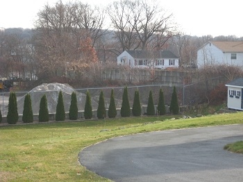
Central Landfill 

The Central Landfill Superfund site is a 154-acre former landfill in Johnston, Rhode Island. During the 1970s, operators disposed of industrial liquid waste in the landfill’s hazardous material disposal area. In 1982, the state ordered the site owner to close this area. EPA placed the site on the National Priorities List (NPL) in 1986.
Cleanup activities included construction of a multi-layer cap, containment and treatment of groundwater, deed restrictions on groundwater use and land use, and evaluation of the site’s landfill gas collection system. Today, the site remains in continued use. Central Landfill, which is owned and operated by the Rhode Island Resource Recovery Corporation, operates on site. It receives over 90% of Rhode Island’s municipal solid waste. Broadrock Renewables, LLC also owns and operates a facility on site that turns gas collected from the landfill into electricity. The company expanded the energy-generating facility in stages. The facility currently includes 15 engine generator sets that produce over 33 megawatts of electricity.
Last updated October 2019
As of December 2019, EPA had data on one on-site business. EPA did not have further economic details related to this business. For additional information click here.
For more information:
Centredale Manor Restoration Project
 Centredale Manor Restoration Project
The Centredale Manor Restoration Project Superfund site includes a 9-acre property in North Providence, Rhode Island, and downstream areas. A chemical company and a drum reconditioning facility operated on site at different times beginning in the early 1940s. Operations ended in 1972 when a fire destroyed most of the facility. Disposal practices included burying waste or releasing chemicals directly onto the ground or into the river. These practices resulted in widespread contamination on site and downstream. Residential development followed – Brook Village Apartments in 1977 and Centredale Manor Apartments in 1983. EPA investigations found contamination in soil, sediment, groundwater, surface water and animals on site.
EPA placed the site on the National Priorities List (NPL) in 2000. EPA’s early actions included capping and fencing the site, as well as removing some contaminated soil from low-lying residential properties and restoring the Allendale Dam. EPA long term cleanup of the site is underway. Today, the Brook Village and Centredale Manor apartment complexes remain on site. EPA’s cleanup approach has been compatible with the site’s continued residential use.
Last updated July 2020
As of December 2019, EPA had data on 3 on-site businesses. These businesses employed 10 people and generated an estimated $1,517,000 in annual sales revenue. For additional information click here.
For more information:
Peterson/Puritan, Inc. 
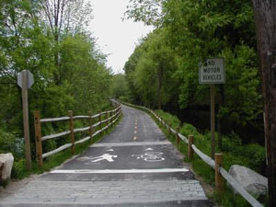 Peterson/Puritan, Inc.The Peterson/Puritan, Inc. Superfund site spans over 500 acres in Providence County, Rhode Island. In 1959, a plant at the north end of the site began packaging aerosol consumer products. A rail car accident and tank spill on the property in 1974 released 6,000 gallons of solvent. In 1979, the Rhode Island Department of Health found contamination in groundwater affecting nearby public well fields. Immediate measures took place to provide an alternative water supply to the local communities. EPA determined that the Peterson/Puritan, Inc. facility was the source of the groundwater contamination.
EPA placed the site on the National Priorities List (NPL) in 1983. In 1990, EPA divided the site into two cleanup areas, known as operable unit 1 (OU1) and OU2. The cleanup design for OU2 began in 2016. For OU1, systems are in place to clean up contaminated groundwater and soil. Cooperation between EPA, the Rhode Island Department of Environmental Management and the community enabled on-site businesses to remain in operation during the cleanup. Megawatt Energy Solutions installed over 2,000 solar panels on the roof of a warehouse building on site in 2014. The solar array produces about 650,000 kilowatts of electricity per year. The warehouse owner also installed a similar system on a second building at the site. The state of Rhode Island and the municipality also completed redevelopment projects on site, including a town dog pound. Other redevelopment includes a riverside park and a bike path along the Blackstone River and Canal. The Blackstone River remains an important natural, recreational and cultural resource for the region. In 2014, the area became part of the national park system as the Blackstone River Valley National Historic Park. EPA’s Superfund Redevelopment Initiative (SRI) supported a regional seed project at the site to update the reuse plan for OU2: J.M. Mills Landfill. The 2018 plan supports the remedial design for OU2 currently underway. Recommendations included additional recreational uses, river access points and Blackstone River heritage exhibits.
Last updated October 2019
As of December 2019, EPA had data on 46 on-site businesses. These businesses employed 725 people and generated an estimated $95,566,215 in annual sales revenue. For additional information click here.
For more information:
- Reuse and the Benefit to Community: Peterson/Puritan, Inc. Case Study (2014) (PDF) (19 pp, 1.3 MB, About PDF)
- Superfund Site Profile Page
Rose Hill Regional Landfill
 Rose Hill Regional LandfillThe Rose Hill Regional Landfill Superfund site is a former municipal landfill in South Kingstown, Rhode Island. From 1967 to 1983, South Kingstown leased the land for use as a domestic and industrial waste disposal facility. Improper disposal activities contaminated site groundwater, soils and three nearby private wells. Runoff contaminated nearby surface water bodies. EPA discovered the contamination in 1981. In 1983, the facility stopped operations. The operator graded and seeded the disposal areas.
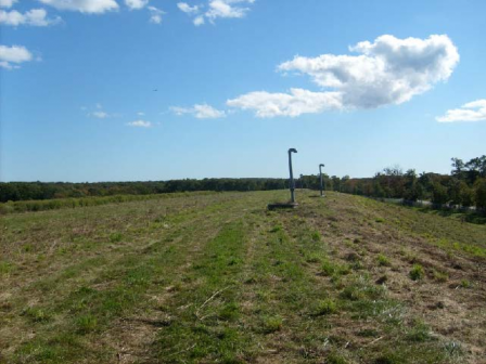
In 1989, EPA placed the site on the National Priorities List (NPL). Early investigations found landfill gases moving off site toward nearby homes. Cleanup activities included extending the municipal water supply to residences with contaminated wells, installing gas alarms for nearby residences and relocating one residence. Landfill cleanup includes consolidating landfill areas, capping the landfill, installing a landfill gas destruction system, monitoring, and restricting groundwater use. EPA will determine the need for additional cleanup activities based on monitoring. A South Kingston transfer station for municipal wastes is located on part of the site. Surrounding land uses support a hunting preserve, a bird dog kennel and field training facilities, and a pet cemetery. The South Kingstown Town Council also authorized development of a solar photovoltaic energy farm on the property. The 4.7-megawatt solar farm was completed in 2018 on the landfill caps.
Last updated October 2019
As of December 2019, EPA had data on 2 on-site businesses. These businesses employed 10 people and generated an estimated $1,185,000 in annual sales revenue. For additional information click here.
For more information:
- Redevelopment of the Rose Hill Regional Landfill Superfund Site (PDF)(2 pp, 1.4 MB)
- Superfund Site Profile Page
West Kingston Town Dump/URI Disposal Area
Two former dumping areas in South Kingston, Rhode Island, make up the 18-acre West Kingston Town Dump/University of Rhode Island (URI) Disposal Area Superfund site. A gravel mine began operating on part of the site, the West Kingston Town Dump area, in the 1930s. From the late 1940s until 1975, a gravel mine also operated on site, at the URI Disposal Area. Starting in 1951, area towns and URI began disposing of unregulated waste on site. The dump closed in 1978. However, disposal continued until at least 1987. Starting in 1988, the state connected affected residential wells nearby to city water. A 1989 inspection found leaking drums next to the site. Drum contents contaminated subsurface soil and groundwater.
EPA placed the site on the National Priorities List (NPL) in October 1992. For cleanup, the potentially responsible parties combined waste from both areas and capped it on site. In 2009 and 2011, EPA injected chemicals to help break down contaminants in the groundwater. Operation and maintenance activities and groundwater monitoring are ongoing. Residents and URI students currently use walking trails on site. In 2018, Kearsarge Energy constructed a 1.2-megawatt solar facility on the 8-acre West Kingston Town Dump area, and a 2.7-megawatt facility on the a 14-acre URI Disposal Area and an adjacent field. These facilities have a combined capacity of 3.9 megawatts.
Last updated October 2019
As of December 2019, EPA had data on one on-site business. EPA did not have further economic details related to this business. For additional information click here.
For more information: