Superfund Sites in Reuse in Texas
If you are having trouble viewing the map in your browser, click the 'View larger map' link below
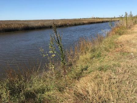
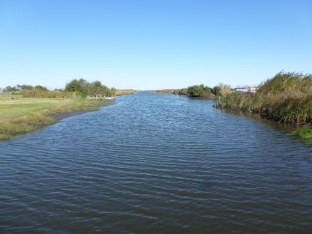
Alcoa (Point Comfort)/Lavaca Bay
The Alcoa (Point Comfort)/Lavaca Bay site is located in Calhoun County, Texas. The area includes the 3,500-acre Alcoa Point Comfort Operations (PCO) Plant, the 420-acre Dredge Island, parts of Lavaca Bay, Cox Bay, Cox Creek, Cox Cove, Cox Lake and western Matagorda Bay. The PCO Plant operated as an aluminum smelter from 1948 to 1980. Bauxite refining, which utilizes bauxite ore to produce alumina, began in 1958. Former operations included the smelter, cryolite plant, chlor-alkali plant, and Witco coal tar processing plant. These facilities have been dismantled and removed. Releases from activities at the facilities resulted in contamination of soil and sediment in Lavaca Bay. The Texas Department of State Health Services (TDSHS) (formerly the Texas Department of Health) has sampled fish, crabs, and oysters in Lavaca Bay since the 1970s. In the early 1970s, TDSHS found significantly elevated mercury levels in oysters and crabs. EPA added the site to the National Priorities List (NPL) in 1994. EPA selected the remedy for the site in 2001. Cleanup activities led by Alcoa include extraction and treatment of groundwater; relocation and stabilization of contaminated material on Dredge Island; sediment dredging with disposal at Dredge Island; installation of caps over waste; monitored natural recovery of sediment in Lavaca Bay; and monitoring of sediment, fish and shellfish. In 2000, TDSHS opened a previously-closed part of Cox Bay due to decreased mercury in finfish and crabs. EPA completed the most recent Five-Year Review at the site in 2016 and found the remedy to be protective in the short term. Commercial and recreational activities continue at Lavaca Bay. The area is valued by local industry for navigable waterways, including a deep-water port to support shipping. Lavaca Bay offers boat ramps, piers, docks and bait shops that support recreational fishing. These facilities also support commercial shrimping, fishing, crabbing and oystering. The Bay provides natural habitat for aquatic and avian species. The Bay is also a source of industrial cooling water.
Last updated September 2019
As of December 2019, EPA did not have economic data related to on-site businesses, or economic data were not applicable due to site use. For additional information click here.
For more information:
Bailey Waste Disposal 
 Bailey Waste DisposalThe 280-acre Bailey Waste Disposal Superfund site is located about three miles from Bridge City, Texas. The site was originally part of a tidal marsh near the confluence of the Neches River and Sabine Lake. In the early 1950s, the property owner built two ponds on the site by dredging the marsh and piling the sediments to form levees around the ponds. In the 1950s and 1960s, the property owner allowed industrial and municipal waste disposal on part of the site. EPA placed the site on the National Priorities List (NPL) in 1984 to address soil and sediment contamination. Key cleanup actions included disposing of some waste off site and capping remaining waste material on site. Potentially responsible parties completed cleanup actions in 1997. These actions protected sensitive areas and made them safe for wildlife and recreation. A portion of the site also hosts a private residence. Site inspection and maintenance activities are ongoing.
Last updated September 2019
As of December 2019, EPA did not have economic data related to on-site businesses, or economic data were not applicable due to site use. For additional information click here.
For more information:
Bandera Road Ground Water Plume 
The Bandera Road Ground Water Plume Superfund site is located in Leon Valley, Texas. The site includes an area of groundwater contamination that is about a mile long and a half-mile wide. This plume of groundwater contamination is centered in a business area, with some residential homes nearby. Past business operations nearby caused the contamination. The Texas Commission on Environmental Quality (TCEQ) discovered the groundwater contamination in 2004. TCEQ installed water filtration systems on five private wells. EPA placed the site on the National Priorities List (NPL) in 2007. EPA connected affected residents to municipal water lines in 2008. Businesses continue to operate at groundwater contamination source areas. The site area also includes the Huebner-Onion Homestead and Stagecoach Stop. This historic resource, dating to 1862, is listed on the National Register of Historic Places.
Last updated September 2019
As of December 2019, EPA had data on 4 on-site businesses. These businesses employed 5 people and generated an estimated $3,357,000 in annual sales revenue. For additional information click here.
For more information:
Big Tex Grain Co. 
The 7.5-acre Big Tex Grain Co. site is located at the 300 block of Blue Star Street in San Antonio, Texas. From 1961 to 1989, several industrial activities took place on site, including vermiculite exfoliation, grain production and sawdust warehousing. During this time, the plant received over 100,000 tons of asbestos-contaminated raw vermiculite ore. Plant operations contaminated dust, air and soil with asbestos. An EPA assessment found that the site was highly contaminated with asbestos. In late 2008, EPA completed cleanup actions, removing contaminated soil, disposing of contaminated materials off site and cleaning on-site buildings. Early in the cleanup process, the site owner expressed interest in redeveloping the site after cleanup finished. EPA issued a Ready for Reuse Determination for the site in August 2012 stating that the site was ready for unrestricted reuse. In 2012, the city of San Antonio approved $5 million in tax incentives and an economic development grant to help fund development of a mixed-use complex at the site. Project construction began in October 2014 and is now complete. The Flats at Big Tex development features apartments and townhomes, restaurants and retail space, and retains several historic property features such as a large grain solo.
Last updated September 2019
As of December 2019, EPA had data on 3 on-site businesses. These businesses employed 5 people and generated an estimated $370,000 in annual sales revenue. For additional information click here.
For more information:
- Big Tex Grain Site Ready for Reuse Determination (PDF)(30 pp, 2.4 MB, About PDF)
- Superfund Site Profile Page
Falcon Refinery
The 104-acre Falcon Refinery Superfund site is located near Ingleside, Texas. The inactive refinery produced various petroleum products intermittently since 1980. Refinery activities and waste disposal practices contaminated nearby Redfish Bay sediments and the site soil and sediments with hazardous chemicals. EPA added the site to the National Priorities List (NPL) in 2011. Cleanup activities are ongoing. The site refinery is currently inactive. The current owner of the property uses it as a crude oil storage and transfer facility. The property owner is in the process of refurbishing and reusing eight aboveground storage tanks on the site.
Last updated September 2019
As of December 2019, EPA had data on one on-site business. EPA did not have further economic details related to this business. For additional information click here.
For more information:
Jones Road Ground Water Plume
The Jones Road Ground Water Plume Superfund site is located in Harris County, Texas. The site consists of the 2.1-acre Cypress Shopping Centre property and plumes of contaminated groundwater. From 1988 to 2002, Bell Dry Cleaners operated on site and used tetrachloroethylene (PCE) as a dry-cleaning solvent. This former dry cleaner facility is the source of the site contamination. A 2001 assessment found PCE in site groundwater. EPA placed the site on the National Priorities List (NPL) in 2003. In 2008, EPA conducted a time-critical removal action, which included the installation and connection of a water line to nearby homes and businesses. EPA selected remedies for soil and groundwater at the site in 2010 and amended the remedy for soil in 2017. These remedies include soil and groundwater treatment and restrictions on groundwater use. Cleanup activities are currently ongoing. Several businesses are located on site. Businesses include a book store, nail salon, automotive store, restaurants, fitness facility, executive suites, and a dog day care.
Last updated September 2019
As of December 2019, EPA had data on 13 on-site businesses. These businesses employed 38 people and generated an estimated $1,634,600 in annual sales revenue. For additional information click here.
For more information:
Main Street Ground Water Plume
The Main Street Ground Water Plume Superfund site is located in Burnet County, Texas. The site is about a mile south of the city limits of Burnet. Tetrachloroethylene (PCE)-contaminated groundwater from an unknown source reached the aquifer, creating a contaminated groundwater plume. The Texas Commission on Environmental Quality (TCEQ) discovered site contamination in 2010. EPA added the site to the National Priorities List (NPL) in 2015. EPA anticipates that the remedial investigation and feasibility study will be completed in 2020. Residential areas, pasture lands and the city of Burnet Wastewater Treatment Plant are located at the site.
Last updated September 2019
As of December 2019, EPA did not have economic data related to on-site businesses, or economic data were not applicable due to site use. For additional information click here.
For more information:
North Cavalcade Street
The 21-acre North Cavalcade Street Superfund site is located in an industrial, commercial and residential section of Houston, Texas. The site is the former home of Houston Creosoting Company, Inc. (HCCI), a wood-treating business that operated on site from 1946 to 1961. Facility operations and waste disposal practices caused contamination in soil and groundwater. By 1980, a warehouse and metal casting shop were built on site. EPA placed the site on the National Priorities List (NPL) in 1986. Final cleanup actions included soil containment and capping, in-place stabilization of two groundwater source areas, establishment of a Technical Impracticability Zone and long-term monitoring. Groundwater monitoring of the site and the Technical Impracticability Zone is ongoing. The northern part of the site, excluding the cap, is available for reuse. Two businesses, a warehouse and an engine component distribution and manufacturing company, are located on the southern part of the site. The Harris County Toll Road Authority plans to extend Hardy Toll Road along the site’s western boundary to ease traffic flow to and from downtown Houston. The Toll Road Authority plans to build the extension on a former railroad easement next to the site.
Last updated September 2019
As of December 2019, EPA had data on one on-site business. This business employed 8 people and generated an estimated $2,254,000 in annual sales revenue. For additional information click here.
For more information:
Palmer Barge Line
The 17-acre Palmer Barge Line Superfund site is located east-northeast of Port Arthur, Texas. The local government used the area as a municipal landfill from 1956 to 1987. In 1982, Palmer Barge Line purchased part of the site for a barge and marine vessel service and maintenance facility. After investigations by the Texas Natural Resource Conservation Commission (TNRCC) and EPA found contamination, EPA placed the site on the National Priorities List (NPL) in 2000. Cleanup actions in 2000 and 2007 included waste removal, water treatment, oil/water separation, sludge stabilization, and removal of contaminated soil and sludge. After cleanup, EPA took the site off the NPL in 2012. Tubal-Cain Holdings Company purchased the site property in mid-2015. In 2017, Tubal-Cain completed construction of an industrial services facility and headquarters building on site.
Last updated September 2019
As of December 2019, EPA had data on one on-site business. This business employed 30 people and generated an estimated $4,000,000 in annual sales revenue. For additional information click here.
For more information:
- Redevelopment of the Palmer Barge Line Superfund Site (PDF)(3 pp, 2.4 MB)
- Reuse and the Benefit to Community: State Marine of Port Arthur/Palmer Barge Line Superfund Sites (PDF)(9 pp, 807 K)
- Superfund Site Profile Page
Petro-Chemical Systems, Inc. (Turtle Bayou)
 Petro-Chemical Systems, Inc. (Turtle Bayou)The Petro-Chemical Systems, Inc. (Turtle Bayou) Superfund site is located in a rural area 15 miles southeast of Liberty, Texas. Site operations started before 1970 and continued until the late 1970s. Parties dumped waste oils on County Road (CR 126) and into unlined waste pits along the road. After 1974, the site was divided into 5-acre and 15-acre plots that were sold for residential development. EPA placed the site on the National Priorities List (NPL) in 1986 to address soil and groundwater contamination. Cleanup of CR 126 included the excavation of contaminated soils and reconstruction of CR 126 using clean materials. Liberty County is responsible for long-term maintenance of CR 126. As part of the cleanup of the other contaminated areas of the site, responsible parties have bought out some of the site’s residential properties. For residents who live within 1,000 feet of contaminated areas and who are not interested in relocating, one of the responsible parties has bought out their groundwater rights. Groundwater monitoring of the site is ongoing. Technical Impracticability Zones, where groundwater cleanup goals cannot be achieved, have been implemented at different areas of the site. Today, the site supports continued residential, agricultural and public service use – CR 126 crosses the site. Parts of the site support recreational hunting and commercial logging companies as well.
Last updated September 2019
As of December 2019, EPA did not have economic data related to on-site businesses, or economic data were not applicable due to site use. For additional information click here.
For more information:
San Jacinto River Waste Pits
The San Jacinto River Waste Pits Superfund site is located in Harris County, Texas. In the mid-1960s, operators built impoundments on site for the disposal of paper mill wastes. The northern impoundments cover about 14 acres and are partially submerged in the San Jacinto River. The southern impoundment covers less than 20 acres. EPA placed the site on the National Priorities List (NPL) in 2008. In 2010, EPA required the site’s potentially responsible parties (PRPs) to construct a temporary armored cap to stabilize the northern impoundments to withstand forces sustained by the river. Since its completion in 2011, the armored cap has generally isolated the waste, but has needed repairs and maintenance. In 2017, EPA issued the final cleanup plan for the site. The PRPs have agreed to design the site’s cleanup under oversight of EPA and the Texas Commission on Environmental Quality. While this effort is underway, PRPs will continue to monitor the temporary armored cap quarterly. The southern impoundment area is in continued commercial and industrial use as warehouses and a port.
Last updated September 2019
As of December 2019, EPA had data on 5 on-site businesses. These businesses employed 521 people and generated an estimated $122,675,193 in annual sales revenue. For additional information click here.
For more information:
Sikes Disposal Pits
The 185-acre Sikes Disposal Pits site is located near Crosby, Texas. From 1955 until 1968, an illegal open dump operated on site. Initial investigations discovered about 2,000 drums of waste. Waste disposal operations contaminated soil and groundwater with hazardous chemicals. EPA placed the site on the National Priorities List (NPL) in 1983. Cleanup activities included excavation and incineration of contaminated soil and sludge, on-site disposal of residue ash from incineration, backfilling of pits and excavated areas, treatment of contaminated surface water, groundwater monitoring, and institutional controls. After cleanup, a honeybee farm operated from about 2011 until 2016. A marina operates on the southwest corner of the site; the marina owners live on site as well. Recreational fishermen use the ponds at the marina for fishing. Recreational campers and boaters also use the marina area as a campground and as a boat launch to the San Jacinto River. Sports fishermen and water sport enthusiasts frequent the area on the nearby Jackson Bayou and San Jacinto River. Both Jackson Bayou and the San Jacinto River have designated beneficial uses for contact recreation and high aquatic life habitat.
Last updated September 2019
As of December 2019, EPA had data on one on-site business. This business employed one person and generated an estimated $173,000 in annual sales revenue. For additional information click here.
For more information:
South Cavalcade Street
 South Cavalcade StreetThe 66-acre South Cavalcade Street Superfund site is located about three miles north of downtown Houston, Texas. A wood preserving facility operated on the site from 1910 to 1962. Owners also built a coal tar distillation plant on the southeastern portion of the site. The distillation plant operated from 1944 to 1962. After the discovery of contamination, EPA placed the site on the National Priorities List (NPL) in 1986. Cleanup included consolidating and capping contaminated soils and installing a groundwater pump-and-treat system. In 2014, EPA selected a new groundwater remedy. Groundwater monitoring of the site and Technical Impracticability Zone is ongoing. In 2000, the responsible party installed concrete caps that serve as truck parking. Pavement, buildings and storage areas cover much of the site, particularly on its southern half. A commercial business purchased the northern half of the site in 2014. Businesses use the site for commercial and industrial purposes. These uses include distribution, warehousing, car sales and pallet supplies. Harris County Toll Road Authority has expanded the street adjacent to the southern side of the site and plans to extend the toll road next to its western edge.
Last updated September 2019
As of December 2019, EPA had data on 4 on-site businesses. These businesses employed 89 people and generated an estimated $70,321,000 in annual sales revenue. For additional information click here.
For more information:
Star Lake Canal
 Star Lake CanalThe Star Lake Canal Superfund site is located in Jefferson County, Texas, in and around the cities of Port Neches and Groves. The site includes two industrial canals and associated wetlands. The two canals are the Star Lake Canal and the Jefferson Canal. Since the late 1940s, the canals have served as industrial wastewater and stormwater outfalls for nearby chemical and manufacturing facilities. Unpermitted and permitted discharges to both canals contaminated surface water and sediments. Dredged sediments placed on the bank of Jefferson Canal contaminated soil in some areas. In March 1983, the Texas Department of Water Resources collected sediment samples from Jefferson Canal and noted many types of polycyclic aromatic hydrocarbons (PAHs). After further investigations, EPA placed the site on the National Priorities List (NPL) in 2000. EPA selected the site’s remedy in 2013. It includes excavation, disposal and capping of contaminated soil and sediments, as well as monitored natural recovery. Work began on the remedial design in October 2016 and is ongoing. Nearby chemical and manufacturing facilities continue to use both canals for industrial and stormwater purposes, but water is now treated at a wastewater treatment plant prior to release in accordance with state water discharge permits. Numerous pipelines and the Lower Neches Valley Authority (LNVA) Atlantic Canal cross the site. Area businesses use the LNVA Canal to transport water to industrial facilities in the area. A U.S. Army Corps of Engineers levee and pumping station is also located at the site and is part of the flood control plan for the region. Site wetlands are habitat for state-designated threatened species. Locals use the Molasses Bayou area of the site for limited recreation, including fishing.
Last updated September 2019
As of December 2019, EPA did not have economic data related to on-site businesses, or economic data were not applicable due to site use. For additional information click here.
For more information:
State Marine of Port Arthur
The State Marine of Port Arthur Superfund site is a 17-acre industrial tract of land located east of Port Arthur, Texas. In the 1960s and 1970s, parties used the area for municipal landfill and barge-cleaning operations. In 1998, EPA placed the site on the National Priorities List (NPL). In 2001, EPA removed source materials from the site. Cleanup activities included waste removal, water treatment, oil/water separation, and sludge stabilization and off-site disposal. After the removal action, EPA took the site off the NPL in 2012. Tubal-Cain, a marine steel fabrication and vessel-cleaning company, purchased the site property in mid-2015. Two of its subsidiaries, Tubal-Cain Marine Services and Tubal-Cain Gas Free Services, now operate on site.
Last updated September 2019
As of December 2019, EPA had data on 2 on-site businesses. These businesses employed 120 people and generated an estimated $27,000,000 in annual sales revenue. For additional information click here.
For more information:
- Reuse and the Benefit to Community: State Marine of Port Arthur/Palmer Barge Line Superfund Sites (PDF)(9 pp, 807 K)
- Superfund Site Profile Page
United Creosoting Co.
The 100-acre United Creosoting Company Superfund site is located in Conroe, Texas. The site is about 40 miles north of Houston. From 1946 to 1972, the United Creosoting Company operated a wood preserving facility on site. Operators treated formed lumber such as telephone poles and railroad ties. In 1977, developers built a residential subdivision and light industrial facilities on part of the site. After the discovery of contaminated soil and groundwater, EPA placed the site on the National Priorities List (NPL) in 1984. Cleanup included removal and off-site disposal of highly-contaminated soils, treatment and capping of less-contaminated soils, and groundwater monitoring. The Conroe municipal water supply connects to all buildings on site. The Texas Commission on Environmental Quality conducts groundwater monitoring and leads all site operation and maintenance activities. Residential and light industrial land uses at the site are ongoing. More recently, commercial businesses have been operating on the site.
Last updated September 2019
As of December 2019, EPA had data on 6 on-site businesses. These businesses employed 20 people and generated an estimated $3,935,581 in annual sales revenue. For additional information click here.
For more information: