Superfund Sites in Reuse in Vermont
If you are having trouble viewing the map in your browser, click the 'View larger map' link below
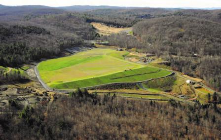
Elizabeth Mine 

 Elizabeth MineThe Elizabeth Mine Superfund site is located in Strafford and Thatford, Vermont. The site contains waste rock, roast beds and mine tailings left behind after 150 years of mining activity. Mining wastes contaminated groundwater, soil and sediment with heavy metals and acid-rock drainage. Mining wastes also contaminated the adjacent West Branch of the Ompompanoosuc River, Lord Brook and two tributaries.
EPA placed the site on the National Priorities List (NPL) in 2001. In 2005, EPA stabilized the tailing pile with soil and repaired the tailing dam. These activities prevented the release of mining waste and potential catastrophic loss of life and property downstream. EPA built a water treatment system in 2008. With reuse in mind, EPA consolidated and covered the mining waste in 2012. During cleanup, EPA restored 10 acres of wetland for ecological reuse. In 2014, the U.S. Army Corps of Engineers Sustainability Award Program presented the Green Dream Team Award to the Elizabeth Mine Superfund Site Project Delivery Team for wetland restorations at the site. As a result of the cleanup, the state of Vermont delisted the 4 miles of the impaired West Branch of the Ompompanoosuc River and portions of Lord Brook from the Clean Water Act’s impaired waters list based on the recovery of the benthic and fish communities. In 2017, a developer installed a 7-megawatt solar array on the radiated tailings pile. The array will supply energy to the Green Mountain Power grid and produce enough power for about 1,300 homes annually.
Last updated October 2019
As of December 2019, EPA did not have economic data related to on-site businesses, or economic data were not applicable due to site use. For additional information click here.
For more information:
- Site Redevelopment Profile for the Elizabeth Mine Superfund Site (PDF)(2 pp, 562 K)
- Superfund Site Profile Page
Ely Copper Mine 
The 350-acre Ely Copper Mine Superfund site is located in Vershire, Vermont. From 1821 until 1920, copper mining operations generated piles of waste rock, smelter waste and tailings. Operators disposed of the materials on site. Mining operations stopped at the site in 1920. Activities to remove dump-ore took place between 1949 and 1950.
EPA placed the site on the National Priorities List (NPL) in 2001. EPA finalized cleanup plans for the site in 2016. Since 1950, activities at the site have included commercial timber management as well as hunting, snowmobile riding and horseback riding. The site includes historic mining-related artifacts. The site also provides habitat for several species of state and federal threatened and endangered bats.
Last updated October 2019
As of December 2019, EPA did not have economic data related to on-site businesses, or economic data were not applicable due to site use. For additional information click here.
For more information:
Pownal Tannery 
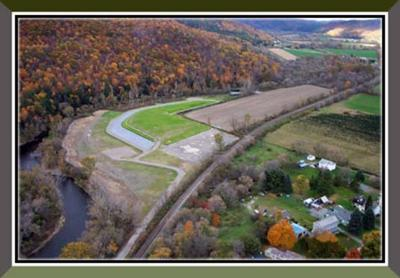 Pownal TanneryThe 28-acre Pownal Tannery Superfund site is located in North Pownal, Vermont. Beginning in the late 1880s, a woolen mill occupied the site. Starting in 1935, a hide tanning and finishing facility operated on site. After the facility closed in 1988, EPA found contamination in groundwater, soil and sludge. EPA placed the site on the National Priorities List (NPL) in 1999. EPA led two emergency removal cleanup actions. EPA removed contaminated materials and the tannery mill building, decontaminated a facility warehouse, and capped a facility landfill. EPA completed these activities in 2001. Further investigations resulted in a 2002 cleanup decision. This cleanup included treating soil and sludge on site and placing it beneath a protective cap. The final remedy also required land use restrictions and long-term monitoring of groundwater and river sediments. EPA worked with the town of Pownal (the Town) to coordinate reuse planning as part of the cleanup process. Funded by a 1999 Superfund Redevelopment pilot grant, the Town developed plans for recreation areas and a new wastewater treatment plant on site. The treatment plant, completed in 2006, occupies part of the former lagoon area. The Town reused old forest beams from the former tannery building to build a recycling center and town equipment shed. Recreation areas include a small park, playing fields, benches, a historic marker near the North Pownal Bridge and walking paths in the former lagoon area. In 2017, Hoosic River Hydro LLC completed construction of a hydroelectric plant at a dam next to the site.
Last updated October 2019
As of December 2019, EPA did not have economic data related to on-site businesses, or economic data were not applicable due to site use. For additional information click here.
For more information:
Tansitor Electronics, Inc.
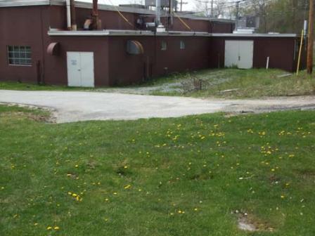 Tansitor Electronics, Inc.The 44-acre Tansitor Electronics, Inc. Superfund site is located in Bennington, Vermont. About 36 acres of the site are located north of Route 9. The rest of the site is south of Route 9. Since 1956, various owners have made electrical components on part of the site. In 1981, Vishay-Tansitor notified EPA that operations between 1956 and 1979 had disposed of organic solvents and acids at the site. Disposal practices contaminated soil, sediment, groundwater and surface water.
EPA placed the site on the National Priorities List (NPL) in 1989. The cleanup plan included a waiver of groundwater standards for a 10-acre area of the site. The cleanup plan also included steps to address monitoring results and place restrictions on groundwater use. Outside the 10-acre area, groundwater contaminant concentrations are below cleanup goals. EPA took the site off the NPL in 1999. Groundwater monitoring is ongoing. Vishay-Tansitor continues to operate its manufacturing facility on site. The Town of Bennington-West Road Pump Station operates on site. Forested wetlands cover most of the site south of Route 9.
Last updated October 2019
As of December 2019, EPA had data on 2 on-site businesses. These businesses employed 87 people and generated an estimated $17,000,000 in annual sales revenue. For additional information click here.
For more information: