Section 18: Soil Exposure Pathway- Resident Population Threat
18.1 Overview of Pathway
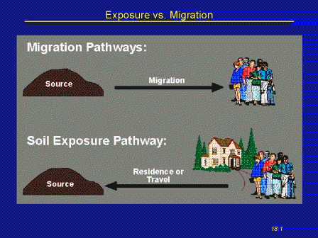
This exposure pathway differs from the three migration pathways (ground water, surface water, air) in several respects: The likelihood that targets will be exposed to hazardous substances where these substances are currently located is the focus. In a sense, this could be called a "people migration pathway" rather than a hazardous substance migration pathway.
-
- The evaluation is based on "areas of observed contamination" rather than HRS sources.
- Although the traditional name for this exposure pathway is "soil exposure," materials other than soil are considered. Any hazardous wastes with which a person might come into contact can be considered, providing they meet certain criteria discussed below.
- Surface impoundments, tanks, and piles are examples.
- Two threats are evaluated and summed HRS rule, Table 5-1, page 51646
- The nearby population threat evaluates people who, upon leaving their home or daycare, might come into contact with hazardous substances on nearby contaminated properties.
- The resident population threat evaluates people, sensitive environments, and resources that are currently located on contaminated properties.
- In terms of scoring dynamics, this threat is equivalent to an observed release and actual contamination of targets in a migration pathway.
- The nearby population threat evaluates people who, upon leaving their home or daycare, might come into contact with hazardous substances on nearby contaminated properties.
- In terms of scoring dynamics, this threat is equivalent to potential to release and potential contamination of targets in a migration pathway.
- Both threats emphasize property boundaries. The essential step in the evaluation of the threats is to overlay a map of property boundaries on the map of the areas of observed contamination.
18.2 Areas of Observed Contamination
- The areas of observed contamination are established by a three-step process:
- Establish points of observed contamination by sampling.
- Establish areas associated with these points.
- Delete sub-areas as required.
1. Sampling locations document points of observed contamination:
HRS rule, page 51646 section 5.0.1, first bullet, left column
- The sampling points will be associated with HRS sources (landfill, impoundment, contaminated soil...) but document a point of observed contamination only if hazardous substances are found at observed release criteria within the top two feet, if not at the surface.
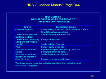
- When soil is sampled, care must be taken to assure an adequate and appropriate background level.
Guidance for Performing Site Inspections Under CERCLA (540-R-92-021), page 76
- The HRS Guidance Manual suggests what might constitute adequate background samples or level for comparison.
- Points of observed contamination cannot be documented without sampling. No samples, no soil exposure pathway.
- The "covered by 2 feet or less of cover material" is meant to be protective of normal homeowner activities.
- Do not composite samples over two feet in depth for this pathway. Because the areas of observed contamination will be overlain by property boundaries, it is also preferable not to composite samples across location.
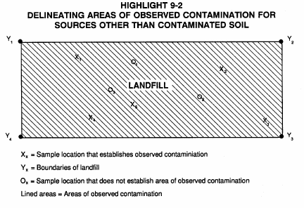
2a. If a sample that documents observed contamination is taken from a source other than contaminated soil, the entire source is considered to be an area of observed contamination.
HRS rule, page 51646, second bullet, first item under bullet
- Sample, for instance, at a point in a landfill where cover is inadequate or lacking.
- Only one "hit" is required to document the entire source as an area of observed contamination.
2b. If samples that document observed contamination were taken from contaminated soil, consider the areas lying between the sampling points to be an area of observed contamination "unless available information indicates otherwise." Examples:
If the deposition was from stack emissions or wind dispersion, treat the entire area between the outermost samples as an area of observed contamination, even if some samples within that area failed to meet the observed release criteria.
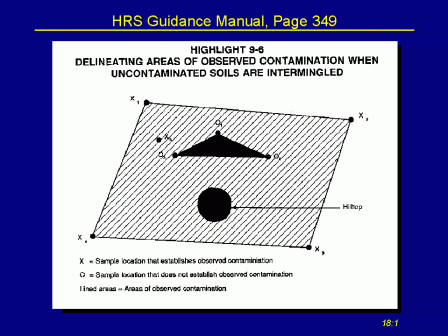
- If the deposition was from runoff or flooding, consider topography in establishing the area of observed contamination.
- If clean fill has been brought in such that a portion of the area under consideration is now covered by more than 2 feet of clean cover, do not consider that area.
- If deposition involved different mechanisms or events, be wary of connecting the areas.
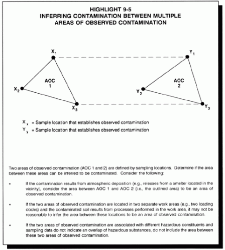 3. After the area of observed contamination has been established, delete sub-areas that are "covered by a permanent, or otherwise maintained, essentially impenetrable material (for example, asphalt) that is not more than 2 feet thick."
18.3 Likelihood of Exposure
- The threat to resident population is assessed by relating targets to areas of observed contamination.
- Note the emphasis on the areas that are defined by the sampling points.
- The sampling strategy for this threat is to assure that critical targets, as defined below, are picked up by the areas of observed contamination that are, in turn, defined by the sampling points.
- The likelihood of exposure is assigned a value of 550 if any one of the following conditions is met. If not, the value is 0 and the resident population threat is not to be evaluated.
Section 5.1 page 51646 of HRS Rule
- An area of observed contamination lies within the property boundary of a residence, school, or day care center and within 200 feet of the respective residence, school, or day care center
- The "within 200" defines an area of about 3 acres. This provision excludes from consideration those situations where the property is large and the area of contamination is on the property but relatively far from the residence, school, or day care center. See Section N of the Preamble to the HRS, page 51560.
- The 200-foot distance measurement is usually from the nearest part of the building but active playground areas have also been included for schools. Consult EPA for site-specific guidance.
- An area of observed contamination lies within the workplace property boundary and within 200 feet of a workplace area.
- The workplace area may be an outdoors area where normal activities may take workers. Document such a situation.
- The workplace area may be an outdoors area where normal activities may take workers. Document such a situation.
- An area of observed contamination lies within a resource area or within a terrestrial sensitive environment.
18.4 Waste Characteristics
- Evaluate for toxicity only those substances that meet the criteria for observed contamination in HRS 55 FR Page 51646, Section 5.0.1.
- The substance was found in a sample at observed release levels.
- The substance, if not at the surface, was covered by two feet or less of cover material (for example, soil).
- Hazardous waste quantity is evaluated using Table 5-2, page 51647, rather than Table 2-5 which is used for the three migration pathways. Note that Table 5-2 is applied to areas of observed contamination, not to sources.
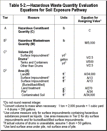
- For tiers A and B (constituent quantity and wastestream quantity) count only those quantities in a liquid-filled area of contamination or that can be documented to be within the top 2 feet of other types of areas of observed contamination (contaminated soil, landfill, pile...).
- For areas of contamination other than liquid-filled impoundments and tanks/drums, this will usually force you all the way from tier A or B to tier D, area.
- For tier C, only liquid-filled impoundments and tanks/drums are considered. Otherwise go to tier D.
- For tier D, the divisors in Table 5-2 are larger than those in Table 2-5 because only the top 2 feet of the assumed depth of the source is considered.
- Because of the focus on areas of observed contamination rather than sources, the values for Hazardous Waste Quantity and for Waste Characteristics are frequently different than for the migration pathways, and if different, are almost always lower.
- For working your way through the tiers and for combining the values for toxicity and quantity, follow the procedure spelled out in Section 5 of this training course.
18.5 Level of Contamination for Human Targets
- All residents and students and day care attendees are evaluated for either Level I or Level II concentrations. Potential exposure is evaluated in the nearby population threat.
- Workers are a separate category in the soil exposure pathway and are not evaluated for level of exposure.
- Terrestrial sensitive environments are evaluated as though they were subject to actual contamination, Level II, because there are no benchmarks for environmental exposure to contaminated soil.
- Level I concentrations require that three criteria be met:
- The person lives or attends school or day care on a property with an area of observed contamination on that property,
- The residence, school, or day care center is within 200 feet of the area of observed contamination,
- A sampling point on the property and within 200 feet contains hazardous substances that meet the criteria for observed contamination and also meet or exceed soil exposure benchmark either individually or in the aggregate (the I or the J index)
For more information about soil exposure benchmarks: SCDM, Soil Benchmarks
For more information on the I or the J index:
- This third criterion means that Level I cannot be inferred between sampling points.
- You will need to take this into account in your sampling plan. Level I targets are worth 10 population points each compared to 1 point to Level II.
- Level II concentrations require that only the first two criteria above be met: an area of observed contamination on the property and within 200 feet of the residence, school, or day care center.
- Level II concentration does not require there be any sampling points on the property.
- Where residences, schools, or day care centers have been built over old landfills or impoundments, one sample that documents a point of observed contamination may pick up substantial targets associated with the area of observed contamination.
- Similarly, when soil contamination is widespread, a relatively few samples that document points of observed contamination can document a large area of observed contamination and may pick up substantial targets.
18.6 Targets
- The target vector includes resident individual, population (Level I or Level II), workers, resources, and sensitive environments.
- Resident Individual: Read the definition of resident individual carefully:
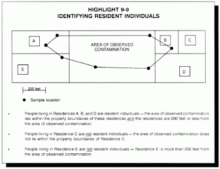
Resident individual - a person living or attending school or day care on a property with an area of observed contamination and whose residence, school or day care center, respectively, is on or within 200 feet of the area of observed contamination. (HRS Rule, Section 5.1.3, page 51647)
The HRS Guidance Manual gives further clarification in Highlight 9-9, page 361 (included below).
- Population: All persons considered as population must meet the definition of resident individual.
- Note that workers are a separate category in this pathway and are not included in the population count.
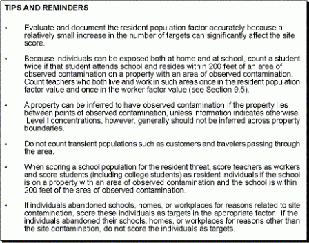
- The HRS Guidance Manual, page 369, contains valuable tips and reminders on how to count population. (see graphic below)
 The Guidance Manual also gives examples on how to assess population in a typical residential neighborhood and for multiple residences on a single property such as trailer parks. See highlights below:
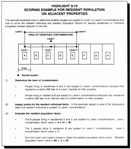
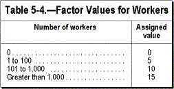
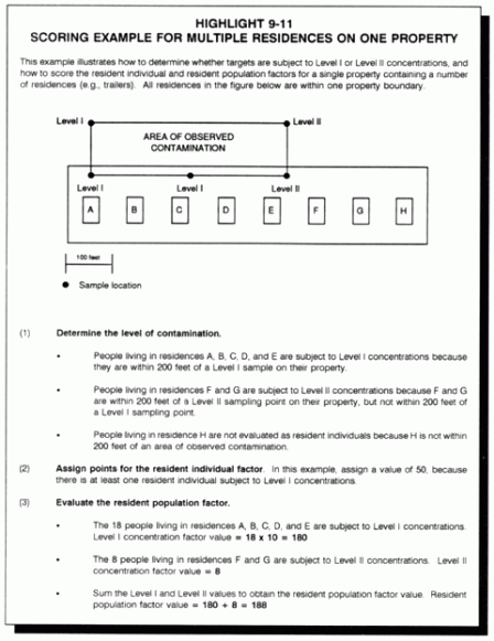 Workers: Workers are evaluated using HRS Table 5-4, page 51647. (included below)
- Workers are treated as a separate category because of the wide range of possible ingestion scenarios. See Section N of the HRS Preamble, page 51563.
- Document that the workers' activities, including parking and lunch breaks, take them within 200 feet of an area of observed contamination and count only those workers for whom such documentation can be presented.
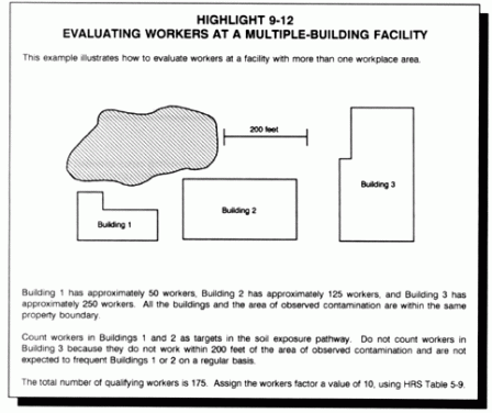 Resources: Certain commercial agricultural resources are counted if they lie on an area of observed contamination.
Determining Resources Factor value
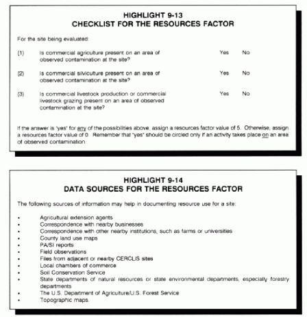 Terrestrial sensitive environments: Terrestrial sensitive environments are counted if they lie on an area of observed contamination. Note: "on an area", not simply within 200 feet.
See Table 5-4, page 51648 below for the list of terrestrial sensitive environments.
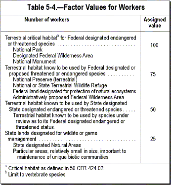 For guidance on how to identify these sensitive environments, review Section 14-4 of this training, Targets: Sensitive Environments in HRS Table 4-23.
The maximum contribution that sensitive environments targets may make to the pathway score is 60 points.
- To determine whether this limit is exceeded, enter the target value for sensitive environments into the pathway formula. If the result exceeds 60.00, you will have to back-calculate the maximum target value for sensitive environments.
- Enter the value for Likelihood of Exposure and Waste Characteristics in the pathway formula, set the formula equal to 60.00, and solve for targets. The HRS gives the formula for doing this on page 51648.

18.7 Questions and Answers
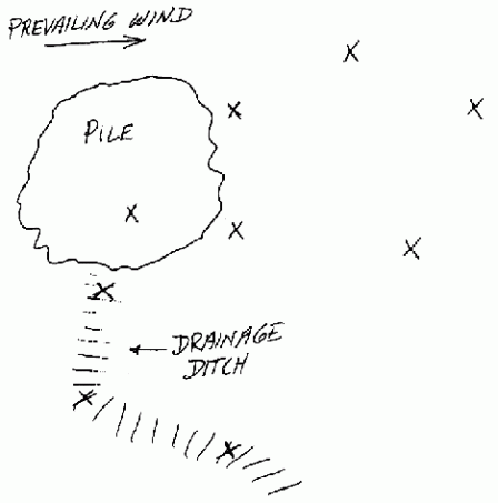
The five sampling points to the right of the pile can be joined to define an area of observed contamination. Do not join this area to the area of the pile. Rather, rely on the two samples near the pile to define the perimeter.
Do not join the area from wind deposition to the area of deposition by runoff unless you can present evidence that the area of wind deposition extends into the runoff area.
Ask EPA to review this illustration and answer
Can surface water sediment samples be considered soil samples in the soil exposure pathway?
Yes, in those cases where the sampling point is "periodically out of water" (HRS Guidance Manual, page 381). Examples are samples from the intertidal zone, samples from wetland areas that are not perennially inundated, samples from intermittent stream beds in arid and semi-arid areas, and samples from the portion of streambeds that are inundated during high-water events but are periodically dry.
EPA Please Review
This may be valuable to remember when contamination is carried as sediments through people's back yards. Sampling in the non-perennial portion of the streambed can document observed contamination.
What observations should be recorded at the site inspection?
What part of the area of observed contamination is covered? Is the cover permanent? Maintained? Essentially impenetrable?
What if the asphalt cover is cracked and pitted?
Document the situation and do not delete the sub-area because it fails to meet the criteria for cover given above.
Can a tank which is shown by sampling to contain a hazardous substance be considered to be an area of observed contamination?
First, what does the tank contain? An excluded substance such as petroleum? Feedstock, process chemicals, or product are also generally excluded from evaluation as CERCLA releases unless they have been leaked or abandoned.
There is no guidance on whether the tank constitutes a "permanent, or otherwise maintained, essentially impenetrable material." Document the condition of the tank and request guidance from EPA.
Guess how many target points result from a household of 4 people subject to Level I concentrations.
That's right, 90 points. The same as for a contaminated well or inake supplying 4 people and contaminated at Level I. 50 points for the MEI risk called resident individual (or nearest well, or nearest intake), and 10 points for each person exposed to Level I concentrations.
Remember the 50 points for Level I and 45 points for Level II? How many points for potential?
Trick question like "Simon says." No points because the resident population threat does not evaluate potential targets. That's done in the nearby population threat.
What about wetlands and species associated with wetlands?
Wetlands and species associated with wetlands are scored in the surface water and the air pathways but not in the soil exposure pathway where consideration is limited to terrestrial sensitive environments.
Navigate to another section of the course:
| Table of Contents | |||||||||
|---|---|---|---|---|---|---|---|---|---|
| 1 | 2 | 3 | 4 | 5 | 6 | 7 | 8 | 9 | 10 |
| 11 | 12 | 13 | 14 | 15 | 16 | 17 | 18 | 19 | 20 |
