Urban Waters Small Grants Mapping
2015/2016 Grants Competition
Request for Proposals EPA-OW-IO-15-01
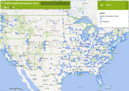
Mapping Overview
For the 2015/2016 cycle of the Urban Waters Small Grants competition, proposed project activities must take place entirely within one of the Eligible Geographic Areas, as outlined in Section I.B of the RFP. The Eligible Geographic Areas are based on the U.S. Census-defined Urbanized Areas and the 12-digit hydrologic unit code system (HUC-12) that defines the watershed. The HUC system is a national standard watershed system based on surface hydrologic features and delineated by the U.S. Geological Survey.
Project Area Map
The Project Area Map is a required document and must be included in the application package as a separate document (See Section IV. D. 4 of the RFP). Applicants must provide a map that demonstrates that the proposed project activities will take place entirely within one of the Eligible Geographic Areas, as illustrated on the interactive map.
Applicants are required to include a project area map showing where proposed project activities will take place.
- The map should be produced using the Urban Waters Small Grants program interactive map.
- Applicants should follow the step-by-step instructions to create the project area map, to be included as part of the application package.
- Step-by-step instructions for creating the project area map