System for Urban Stormwater Treatment and Analysis IntegratioN (SUSTAIN)
Tool for Selecting Best Management Practices to Protect Water Quality
On this Page
Disclaimer: Any mention of trade names, manufacturers, or products does not imply an endorsement by EPA. EPA and its employees do not endorse commercial products, services, or enterprises.
SUSTAIN is a decision support system that assists stormwater management professionals with developing and implementing plans for flow and pollution control measures to protect source waters and meet water quality goals. SUSTAIN allows watershed and stormwater practitioners to develop, evaluate, and select optimal best management practice (BMP) combinations at various watershed scales based on cost and effectiveness.
Note: EPA is no longer developing or supporting SUSTAIN. There are no plans for updated versions.
Software, Compatibility, and Manuals
SUSTAIN installation requires ESRI's ArcGIS 9.3 and the Spatial Analyst extension. The system also requires Microsoft® Excel 2003 or later version, which is used as a postprocessor for analyzing and interpreting results.
| Date | Description |
|---|---|
| 06/2014 | SUSTAIN Version 1.2 non-GIS (ZIP)(30 MB) |
| 06/2014 | SUSTAIN Version 1.2 ArcGIS 9.3(79 MB) |
| 06/2014 | SUSTAIN BMP Siting Tool Version 1.2 - ArcGIS 10.1(15 MB) |
Capabilities
 SUSTAIN can be used to perform hydrologic and water quality modeling in watersheds and urban streams. It searches for optimal management solutions at multiple-scale watersheds to achieve desired water quality objectives based on cost effectiveness. It provides answers to the following questions when developing plans:
- How effective are BMPs in reducing runoff and pollutant loadings?
- What are the most cost-effective solutions for meeting water quality and quantity objectives?
- Where, what type of, and how big should BMPs be?
SUSTAIN has seven modules that are integrated in a common ArcGIS platform:
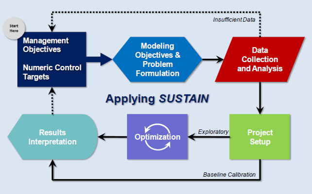
1. Framework Manager: Serves as the command center of SUSTAIN. It manages the data exchanges between system components and coordinates external inputs, calls various modeling components (i.e., land, BMP, conveyance), and provides output information to the postprocessor.
2. BMP Siting Tool: Supports users with selecting suitable locations for common structural BMPs that meet the defined site suitability criteria, such as drainage area, hydrological soil group, groundwater table depth, road buffer, stream buffer, and building buffer.
BMPs are classified and conceptualized in SUSTAIN as scale-based and type-based. The scale-based category classifies BMPs according to the size of the application area, such as lot-, community-, and watershed-scales. The type-base category classifies BMPs into three types according to the geometric properties:
- Point BMPs capture upstream drainage at a specific location and may use a combination of detention, infiltration, evaporation, settling, and transformation to manage flow and remove pollutants. Supported options include bioretention, cisterns, rain barrels, infiltration basins, surface sand filters, constructed wetlands, and dry and wet ponds.
- Linear BMPs are narrow linear shapes adjacent to stream channels that provide filtration of runoff, nutrient uptake, and ancillary benefits of stream shading, wildlife habitat, and aesthetic value. Supported options include infiltration trenches, grassed swales, vegetated filter strips, and non-surface sand filters.
- Area BMPs are land-based management practices that affect impervious area, land cover, and pollutant input. Supported options include porous pavement and geen roofs.
3. Land Simulation Module: This module supports the import of externally generated time series data and computes runoff and pollutant loads from land in one of two ways:
- The hydrograph and pollutograph are computers in by default using algorithms adapted from the Storm Water Management Model (SWMM), version 5.
- Sediment algorithms adapted from Hydrological Simulation Program – FORTRAN (HSPF). Exit
4. BMP Simulation Module: Provides process-based simulation of flow and pollutant transport for a wide range of structural BMPs. Its designed allows new BMPs and alternative simulation techniques to be added. The major processes that encompass the module include flow routing, infiltration, evapotranspiration, pollutant routing and removal, buffer strip flow routing, strip sediment trapping, and pollutant removal. There is a default simulation method option for each process. However, users can select a second option depending on the available data and required level of detail preferred. In addition to the major processes, two additional functionalities are included:
- BMP Cost Estimation in SUSTAIN is expressed in terms of unit costs of individual construction components of a BMP. The unit costs come from wholesale and retail companies that provide raw materials for BMPs, and from multiple sources of BMP implementation at the county, state, and federal levels. The use of this unit cost approach, rather than the entire bulk BMP installation, aims to minimize differences encountered from site or locality factors. Users have the option to override the built-in data with the locally derived information.
- Aggregation of Distributed BMPs allows users to assess the effectiveness of multiple BMPs. It represents the aggregate characteristics of distributed BMPs. At the same time, it reduces the user's model set up effort and the computation time needed for simulation and optimization. Aggregate BMPs evaluate storage and infiltration characteristics of multiple BMPs simultaneously without explicit recognition of their spatial distribution and flow and pollutant routings.
5. Conveyance Simulation Module: Performs routing of flow and pollutants through a conduit. In SUSTAIN, conduits are pipes or channels that move water from one node to another in a watershed routing network. The cross-sectional shapes of a conduit can be selected from a variety of standard open and closed geometries. Irregular natural cross-section shapes are supported, as are user-defined closed shapes. Flow and pollutant routing are simulated using transport algorithms in SWMM5. Sediment routing uses sediment transport algorithms in HSPF.
6. BMP Optimization Module: Identifies cost-effective BMP placement and selection strategies based on a pre-determined list of feasible sites and applicable BMP types and size ranges. This module uses evolutionary optimization techniques to search for cost-effective BMPs that meet user-defined decision criteria. SUSTAIN implements two search algorithms in scatter search and non-dominated sorting genetic algorithm-II (NSGA-II).
Operationally, the optimization module incorporates a tiered approach that allows for cost-effectiveness evaluation of both individual and/or multiple nested watersheds. This helps to address the needs of both regional- and local-scale applications. Tier 1 performs the optimization search to develop cost-effectiveness curves for each Tier 1 sub watershed. Tier 2 uses the Tier 1 solutions to construct a new optimization search domain and run the transport module, if needed, to develop the combined cost-effectiveness curve for the entire Tier 2 watershed.
7. Postprocessor: Microsoft® Excel, the postprocessor provides a centralized location in SUSTAIN for analyzing and interpreting simulation outputs at multiple locations, and for scenarios and parameters of interest. The simulation outputs contain hourly or sub-hourly data. These data can span several years depending on the length of the simulation. The postprocessor allows users to evaluate simulation results that are highly variable in magnitude, duration, intensity, treatment containment volume, attenuation, and pollutant removal effectiveness. SUSTAIN achieves this by using specific graphical and tabular reports: storm event classification, storm event viewer, storm performance summary, and cost-effectiveness curves.
Applications
Various practitioners, municipalities, and watershed groups at the regional and local level can use the SUSTAIN framework to address a variety of planning:
- Developing Total Maximum Daily Load (TMDL) implementation plans.
- Identifying management practices to achieve pollutant reductions under a municipal separate storm sewer system (MS4) stormwater permit.
- Determining optimal green infrastructure strategies for reducing volume and peak flows to combined sewer systems.
- Evaluating the benefits of distributed green infrastructure implementation on water quantity and quality in urban streams.
- Developing a phased BMP installation plan using the cost-effectiveness curve.
Related Resources
Publications
- Stormwater Management for TMDLs in an Arid Climate: A Case Study Application of SUSTAIN in Albuquerque, New Mexico (Report, 2013)
- Enhanced Framework (SUSTAIN) and Field Applications for Placement of BMPs in Urban Watersheds (Report, 2011)
- Current Capabilities and Planned Enhancements of SUSTAIN (Proceedings Paper, 2010)
- SUSTAIN--A Framework for Placement of Best Management Practices in Urban Watersheds to Protect Water Quality. (Report, 2009)
- SUSTAIN – An EPA BMP Process and Placement Tool for Urban Watersheds (Proceedings Paper, 2007)