Lake Michigan
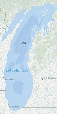 Lake Michigan, by volume, is the second largest Great Lake and the only one located wholly within the United States. The northern part is in the colder, less-developed upper Great Lakes region. It is sparsely populated, except for the Fox River Valley, and is primarily covered with mixed wood forest. The more temperate southern basin of Lake Michigan is the most urbanized area in the Great Lakes system; it contains the Milwaukee and Chicago metropolitan areas.
On This Page:
About Lake Michigan
- the second largest
- the only Great Lake entirely within the United States
- variable climate, population density and development
- northern part: colder, less developed, sparsely populated
- southern basin: more temperate, among the most urbanized areas in the Great Lakes system.
- 20% of the total population of the Great Lakes basin
- Green Bay has one of the most productive Great Lakes fisheries but receives the wastes from the world's largest concentration of pulp and paper mills
NOAA Image Measurement of Depth of Water in Lake Michigan
Environmental Issues
- Lake Michigan Biodiversity Conservation Strategy EXIT
- In 1994, the National Oceanic and Atmospheric Administration (NOAA) produced a series of Environmental Sensitivity Index (ESI) maps for the Lake Michigan shorelines of Indiana and Illinois. They show the sensitivity of coastal environments and wildlife to spilled oil in southern Lake Michigan. These maps include information for three main components:
- shoreline habitats
- sensitive biological resources
- human use resources
What is EPA Doing?
- Lake Michigan LAMPS and Associated Reports
- Lake Michigan Great Lakes Areas of Concern (AOCs)
- Lower Green Bay/Fox River AOC - Wisconsin
- Grand Calumet River AOC - Indiana
- Kalamazoo River AOC - Michigan
- Manistique River AOC - Michigan
- Lower Menominee River AOC - Michigan
- Milwaukee Estuary AOC - Wisconsin
- Muskegon Lake AOC - Michigan
- Sheboygan River AOC - Michigan
- Waukegan Harbor AOC - Wisconsin
- White Lake AOC - Michigan - DELISTED
- Lake Michigan Mass Balance Project (LMMB)
- Lake Michigan Habitat and Land Use Management Tool Box
- Great Lakes Restoration Initiative Grants
- Grand Traverse Conservation District ($301,340) for invasive species prevention.
- Grand Valley State University ($405,275) for invasive species control.
- Ozaukee Washington Land Trust ($514,278) for invasive species control.
- Ozaukee County ($298,869) for invasive species control.
- Milwaukee Metropolitan Sewerage District ($380,000) for urban watershed management implementation.
- Lake County Stormwater Management Commission for ($446,603) for urban watershed management implementation.
- Delta Institute ($355,370) for urban watershed management implementation.
- Great Lakes Community Conservation Corps ($390,995) for urban watershed management implementation.
- Grand Valley Metropolitan Council ($340,065) for urban watershed management implementation.
- Grand Traverse Bay Watershed Initiative ($499,370) for urban watershed management implementation.
- Macatawa Area Coordinating Council ($473,111) for agricultural atershed management implementation.
- Fox-Wolf Watershed Alliance ($498,634) for agricultural watershed management implementation.
- Calhoun Conservation District
- ($160,377) for agricultural watershed management implementation.