Heat Island Newsroom
Welcome to EPA's Heat Island Newsroom, which includes recent issues of the Heat Island Newsletter and other notable news items. To receive the newsletter and notices of heat island-related conferences by email, sign up for EPA's Heat Island Newsletter.

Note: Some of the following links exit the site. Exit
December 14, 2020 Newsletter
General Heat Islands
- New Reports Emphasize Disparities in Access to Cooling Parks and SchoolyardsThe Trust for Public Land recently released two new resources: School’s Out and The Heat Is On. The Heat Is On investigates how race and income relate to access to parks. On average, communities within a 10-minute walking access are cooler than those that lack such access to a park by as much as 6 degrees. Parks serving primarily non-White populations are, on average, half the size of parks that serve majority-White populations and nearly five times more crowded. School’s Out analyzes the millions of students impacted by heat islands around the United States. The report finds that nationwide, 36% of the Nation’s 50.8 million public school students attend school in a heat island, and there is a strong correlation between populations with low income and schools being situated in heat islands. The report recommends opening schoolyards to the public during non-school hours to increase national access to parks and green areas.
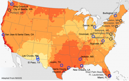
- Campaign Maps Ambient Heat across 13 U.S. Cities For a third summer, the National Oceanic and Atmospheric Administration’s (NOAA’s) National Integrated Heat Health Information System (NIHHIS) and Climate Adaptation Planning and Analytics (CAPA) Strategies continued their Heat Watch program, which engages local organizations and community members in a data collection process and returns high-resolution spatial descriptions of urban heat. Thirteen U.S. cities (identified with blue circles in the map) conducted campaigns in summer 2020, in which local volunteers collected ambient temperature and humidity measurements three times in a single, hot day. In total, over 380 volunteers drove and biked 176 hour-long routes and collected nearly 1.2 million unique measurements of heat, helping to inform area-wide models of temperature and heat index. The next steps span validating the data with local communities; examining overlays with sociodemographic information, land-use and land-cover variables, and historical housing practices; and incorporating the data into ongoing planning efforts such as vulnerability assessments and active transportation plans. The NIHHIS/CAPA team is working to grow their network of over 30 campaign cities. NIHHIS is accepting applications for 2021 urban heat island mapping campaigns. Applications are due January 8, 2021.
- Cambridge, MA, Resilience Plan Tracks Albedo Changes to Reduce Heat Island Effects With support from Thriving Earth Exchange, researchers from the National Aeronautics and Space Administration’s DEVELOP program and Hunter College partnered with Cambridge’s Community Development Department to devise rooftop albedo detection methods and track heat island reductions within the citywide Climate Change Preparedness & Resilience (CCPR) Plan. Specifically, the team worked to devise a replicable, practical, affordable, and consistent methodology to track changes in albedo over time to determine whether the city is successfully reducing its heat island effect. A pilot of the approach indicated that rooftop albedo has increased since 2010 – likely attributable to the increasing availability of higher-albedo roofing materials and the overall trend of green building design. This project expands the city’s capacity to manage heat island effects, along with changes to urban forest canopy and pervious/impervious cover. To ensure that the CCPR Plan is effective, the city is applying benchmarks that would signal the need for future adjustment of heat island cooling strategies.
- Massachusetts Awards Heat Island Reduction Grants to Four Communities The Massachusetts Municipal Vulnerability Preparedness Program recently awarded a series of grants to identify climate hazards, develop strategies to improve resilience, and implement priority actions around the state. Four awards target heat island planning and identification of cooling actions. Boston, MA, was awarded $280,000 to fund a Heat Resilience Planning Study that will focus on “hot spots.” This effort, part of Climate Ready Boston, will develop heat-mitigation scenarios in partnership with communities facing disproportionate effects of urban heat risk – compounded by social inequity. Chelsea, MA, was awarded $262,000 for an Urban Heat Island Mitigation Project. Cambridge, MA, and Metro Mayors were awarded $268,000 for the Building Resilience to Climate Driven Heat in Metro Boston project. Arlington, MA, was awarded $186,000 for the Wicked Hot Mystic project.
Resource Highlight
Cool Materials
- Recent Developments in Designing and Developing Cool Materials In a recent Renewable Energy journal article, researchers reviewed progress on the design, development, and implementation of cooling materials – exhibiting low and very-low surface temperatures. This review presents recent technological advances around natural, light color, infrared reflective, phase change, thermochromic, fluorescent, photonic, and plasmonic materials. The authors found that innovations in photonic materials show enormous cooling potential at a reasonable price, and that photonic materials may play a key role in future cooling strategies. While more research into cooling materials is needed, the results demonstrate that innovative materials can exhibit sub-ambient surface temperatures and contribute greatly to alleviate urban overheating.
Equity
- Can Planting Trees Make a City More Equitable? The Trillion Trees Initiative, launched by American Forests, brings together businesses, nongovernmental organizations, and cities to commit to planting urban trees. Through this initiative, partners have committed to conserve, restore, or grow 855 million trees as a means to encourage reforestation, improve air quality, promote urban cooling, sequester carbon, and improve “tree equity.” Participating entities submit annual data about their forestry practices, and how the planted trees meet both climate change and community engagement goals. Alongside this effort, American Forests is developing a national tree equity score that factors in the heat island effect and neighborhood income levels so cities may use it to inform their work. Cities involved in this initiative include Boise, ID; Dallas, TX; Detroit, MI; and Tucson, AZ; among others.
Green Roofs and Walls
- Can Green Walls Cool Urban Heat? University of Antwerp researchers reviewed recent green wall literature to understand how green walls might be applied to improve urban resilience. The literature shows green walls are a resource to decrease temperatures in urban environments and reduce the heat island effect through increased shading, evapotranspiration, insulation, and ventilation. Green walls lower indoor air and ambient air temperatures, increase thermal comfort for residents, and reduce energy demands for additional cooling. The researchers found that urban green infrastructure, including the use of vertical green walls, may be an effective strategy for cooling at building and street levels; and that shading was the most important factor for cooling.
Public Health
- Cooling Strategies Likely Have Heat Health Benefits for Los Angeles, CA Recent work from researchers at Arizona State University and Applied Climatologists explores two historical extreme heat events in Los Angeles, and the potential for increasing vegetative cover and albedo to reduce total exposure to dangerously hot conditions. For each heat event, the researchers conducted atmospheric model simulations for a control case and four levels of increased albedo and vegetative cover. Accounting for both indirect cooling effects associated with neighborhood implementation of cooling strategies and the direct effects of high-albedo roofing, the researchers developed occupant heat exposure and mortality profiles. The results suggest that improvements in indoor thermal conditions could be associated with a sizable health benefit, signaling a need for large-scale implementation of cooling strategies.
Trees and Vegetation
- Environmental Justice Project Aims to Grow Tree Canopy in Underserved Communities Vibrant Cities Lab – a partnership among the U.S. Forest Service, American Forests, and the National Association of Regional Councils – completed the three-year Growing Tree Canopy through Environmental Justice project focused on delivering in-depth community engagement with tree canopy in the Anacostia watershed located in Prince George’s County, MD. Key accomplishments include the Chesapeake Tree Canopy Management Strategy; the creation of a cross-boundary partnership to achieve tree canopy and community engagement goals; and the development of five case studies featuring environmental justice, community engagement, tree planting, and stewardship projects. Each of the case studies in Baltimore, MD; Detroit, MI; Oakland, CA; Portland, OR; and NJ provides an overall context for the implemented projects and lessons learned. The Detroit and NJ case studies cite the heat island effect as a motivation for efforts to increase coverage in neighborhoods with disproportionately low tree canopy.
- Vegetation Drives Microclimate Variability in the Salt Lake Valley University of Utah researchers found that land cover characteristics drive changes in spatial and temporal temperature variability. The researchers collected data from 60 sensors in 5 urban parks and surrounding neighborhoods in Utah’s semi-arid Salt Lake Valley. Tree shading was associated with higher temperature variability during the day, while turfgrass cover was associated with higher temperature variability at night. Both trees and turfgrass had cooling benefits, suggesting that mixed tree and grass landscapes may be effective in alleviating the heat island effect in semi-arid urban settings.
Did you know?

August 25, 2020 Newsletter
EPA Updates
-
Please Share! Cool Your Community Social Media Toolkit We are launching Cool Your Community – a social media toolkit from the U.S. EPA Heat Island Reduction Program to increase awareness of heat islands, share information on heat island cooling strategies, and encourage individuals to adopt these strategies. We have developed messages and graphics, freely available in English and Spanish, for communities, local governments, organizations, and individuals to share with their networks. The messages focus on the benefits of cool roofs, trees and vegetation, heat equity, heat vulnerability, and more. We encourage you to share them directly with your program’s stakeholders by posting them on your social media accounts, or by letting your stakeholders know about the toolkit through a newsletter or email announcement.
-
Webcast Recording Available! Equity in Action: Heat Planning in Greater Phoenix This June webcast covered how The Nature Conservancy Arizona, Arizona State University, the Maricopa County Department of Public Health, and other partners developed the Heat Action Planning Guide for Neighborhoods of Greater Phoenix. The partners worked directly with community members using a participatory process to identify challenges and create community-driven solutions to mitigate and adapt to future heat. Specific cooling solutions include revitalizing vacant lots with trees and vegetation, and increasing shade along transit routes and at bus stops. This process was designed to develop awareness, increase social cohesion, and foster action in underrepresented communities. This team’s work was also featured in the Washington Post.
-
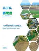
Local Action Framework: A Guide to Help Communities Achieve Energy and Environmental Goals Local and tribal governments are doing the hard work of implementing energy and environmental programs on a community level that reduce air pollution, improve air quality, lower energy costs, support local economic development, improve public health, and increase energy system reliability. Our six-step guide is designed to help local and tribal governments plan, implement, and evaluate new or existing energy or environmental projects. It is intended for small and medium-sized communities and tribes, but may also be relevant for larger jurisdictions or states.

Resource Highlight
General Heat Islands
-
Dallas, TX Comprehensive Plan Sets Ambitious Heat Island Reduction Targets Following the 2017 Dallas Urban Heat Management study, the city’s newest comprehensive plan includes a series of goals to protect and enhance its ecosystems, trees, and green spaces, particularly for vulnerable populations, which will, in turn, improve public health. The plan targets reducing the local heat island index 20% by 2030, 50% by 2040, and 75% by 2050. The plan’s cooling strategies include ongoing efforts to increase the city’s tree canopy, install cool roofs, institute urban greening requirements for new developments, transform vacant lots into pocket parks and gardens, and create green corridors – a city-wide network of urban trails that link neighborhoods with transportation hubs and economic centers.
-
Online Map Depicts Heat Island Intensity and “Disparity” Variables Side-by-Side Students and researchers from several universities launched the interactive Surface Urban Heat Island (SUHI) Disparity Explorer. For major metropolitan centers across the United States and Puerto Rico, it depicts SUHI intensities for day, night, summer, and winter, alongside socioeconomic variables such as race and income. A draft manuscript provides supporting documentation.
-
New Tool Estimates Urban Heat Adaptation Benefits The C40 Cool Cities Network developed a downloadable Excel-based tool to support city planners and designers in quantifying health outcomes such as heat-related illnesses and deaths, environmental outcomes such as heat island reductions, and associated economic benefits. With the tool, users can calculate benefits brought about by specific parks and green infrastructure, water bodies such as rivers and lakes, and cool and vegetative surfaces. This information could be used to formulate adaptation investments and prioritize actions.
-
What is the True Value of Trees, Cool Roofs, and Other Cooling Strategies? Researchers from the Global Cool Cities Alliance and The Nature Conservancy published a research article earlier this year highlighting the economic benefits associated with heat island cooling strategies. This research captures several benefits of heat mitigation: improved energy efficiency, worker productivity, air quality, health, and equity. Using standard cost-benefit tests, it finds that adaption of these strategies has been slower than their economic potential. Such cost-benefit tests could inform program design.
-
Use of Collaborative Decision-Making Frameworks in Heat Response Planning Using the test case of Chatham County, GA researchers explored if the collaborative, multi-stakeholder frameworks of coproduction – an iterative process between science and decision-making fields to develop research questions and methods – and geodesign – a collaborative pathway among landscape architects, planners, and others for plan conception and evaluation – supported heat response planning decision-making. The work included a variety of collaborative methods such as the use of workshops, focus groups, and geodesign drafting software across stakeholders and key informants in multiple fields: planning, public engagement, natural resources, public health, and meteorology. Two workgroups identified and narrowed a series of actions, policies, and projects centered on county-wide green infrastructure and social vulnerability. The researchers concluded that co-production and geodesign frameworks promoted synergist heat response action plans.
- Primer on Passive Heat Islands Reduction Measures The World Bank’s Energy Sector Management Assistance Program primer covers solutions that cities can take to reduce excess heat and the benefits of these solutions. Specific passive cooling strategies include reflective surfaces such as cool roofs, walls, and pavements; permeable infrastructure such as green roofs, green walls, permeable pavements, trees, and parks; water infrastructure; urban design; and reducing waste heat from air conditioners, transit vehicles, and industry. The primer features several policy options for implementing such measures, including awareness-raising activities, incentives, and mandates. Case studies feature Toronto, ON and Washington, DC, among others.
Cool Materials
-
Phoenix, AZ Launches Cool Pavement Pilot This summer the Phoenix Street Transportation Department selected nine locations as part of a new cool pavement pilot project. The city will test if a specific pavement coating treatment is effective at reducing temperatures by engaging Arizona State University researchers to take measurements throughout the coming years. The pilot will uncover if the treatment is durable and helps cool the heat island effect.
-
Results are In for Year One of Denver, CO's Green Building Ordinance In a report for 2019, Denver details the progress of its 2018 green building ordinance. The ordinance applies to new and re-roofed buildings over 25,000 square feet and requires installation of a cool roof in addition to one of several “green” options: installing a green roof/green space, funding it elsewhere, meeting green building certification standards, installing renewable energy, or undertaking energy efficiency. Since the ordinance took effect, Denver issued 65 project permits. The report presents breakdowns of green building options across 51 of these projects. Denver touts that these projects are using less energy, adding more green space, and contributing less to the urban heat island effect, among other environmental benefits.

Green Roofs
-
What Incentives Promote Green Roofs and Walls? In a journal article published in Land Use Policy, researchers reviewed municipality incentive policies that promote the installation of green roofs and walls. Such cooling strategies are used to alleviate multiple impacts of urban development; but with high upfront costs, incentives are one way to promote and facilitate their adoption. The results, covering 113 cities, show that incentive policies fall into 6 categories: tax breaks, financing, permitting, sustainability certification, requirements, and administrative processes. Green roof incentives are mainly concentrated in Europe and North America, and no exclusive green walls policies exist.
Public Health
-
Philadelphia, PA Assesses How Increased Tree Canopy Might Benefit Public Health Greenworks Philadelphia aims to increase tree cover across the city by the year 2025. In a published assessment, researchers used multiple tree canopy scenarios in both lower and higher socioeconomic areas to estimate preventable annual premature deaths associated with physical and mental health benefits of greenspace. Results indicate a low scenario with a 5% increase in tree canopy could reduce 302 yearly deaths. Achieving an ambitious 30% tree canopy coverage could reduce 403 yearly deaths (with a value of nearly $3.9 billion associated with avoided deaths).
-
Interactive Heat & Health Tracker This summer the Centers for Disease Control and Prevention (CDC) created a new Heat & Health Tracker to provide local heat and health information so communities can be better prepared for responding to extreme heat events. This tracker relies on data such as current, historical, and future projected temperatures; heat-related health effects (e.g., emergency department visits, deaths); population characteristics; and community characteristics (e.g., land cover). The tracker's features allow users to search for information by county or Zip code to create custom maps, view data snapshots, and access guidance and resources from CDC and other credible sources.
-
Heat-Related U.S. Deaths A newly released article from CDC researchers summarizes heat-related death data for the United States from 2004 to 2018. The researchers reported 10,527 heat-related deaths in that time period, an average of 702 per year. These numbers include deaths where heat was the underlying or contributing cause. The article highlights the need for preparedness and response initiatives that limit exposure to extreme heat, including coordinated approaches such as surveillance, heat response planning, communication and education activities, and operation of cooling centers.

COVID-19 News and Resources
- COVID-19 and Cooling Centers (CDC)
- Heat and COVID-19 Information Series (Global Heat Health Information Network)
- Coronavirus Makes Cooling Centers Risky, Just as Scorching Weather Hits (New York Times)
- Will Summer Kill Coronavirus? Cities Fear Heat Waves Will Quickly Become Deadly (Washington Post)
- Cities Brace for 'Collision Course' of Summer Heat Waves and COVID-19 (National Public Radio)
- Roadmap for Cities to Address Dangerous Heat during the COVID-19 Pandemic (Global Cool Cities Alliance, Society of Behavioral Medicine)
Trees and Vegetation
-
Pavement to Parks Report Features Many Benefits of Depaving The Urban Land Institute’s report Pavement-to-Parks: Transforming Spaces for Cars into Places for People highlights the role of depaving as an opportunity to promote community connection, improve park access, and enhance environmental sustainability – including cooling heat islands. Many cities dedicate land to automobile storage and transport, including parking lots and garages, roadways, and spaces beneath highway overpasses; however, such spaces could be transformed into parks. This report presents 15 project examples and 4 programmatic examples from cities that have converted or enhanced spaces to support recreation, sustainability, and neighborhood revitalization.
-
How Urban Trees Affect Human Health A cohort of U.S. and Canadian researchers published a comprehensive review of existing literature on the health impacts of urban trees. The review process screened several thousand articles, ultimately narrowing to 201 relevant studies. These studies address three broad categories of health benefits associated with trees: (1) reducing harm, including benefits such as reducing air pollution and heat exposure; (2) building capacities, including benefits such as improving birth outcomes and active living; and (3) restoring capacities, including benefits such as improving mental health and relieving stress. The review points to why urban planners and managers should promote trees and urban forestry as measures to protect public health.
-
Measuring Microclimates in Atlanta, GA At the Georgia Institute of Technology campus in Atlanta, researchers monitored 37 sites spanning built and vegetated environments to identify the distribution and intensity of the surface heat island. Heat island intensities were tracked with levels of tree canopy and landscaping. Vegetated sites had lower temperatures than impervious sites by up to 6.8°F. This method could be applied elsewhere to understand differential heat island intensities and inform cooling strategies.

Did you know?

April 24, 2020 Newsletter
General Heat Islands
- Houston, TX Resilience Framework Aims to Cool Neighborhoods In response to Hurricane Harvey in 2017 and other recent natural disasters, in February, Houston put forward its newly developed Resilient Houston framework. Designed with the 100 Resilient Cities initiative, Shell, and many community stakeholders, the framework aims to build the resilience of Houston’s neighborhoods, especially historically marginalized communities. Resilient Houston is making heat islands a priority with an action and associated steps targeted to “make Houston neighborhoods greener and cooler to combat extreme heat” through a citizen science heat mapping campaign, accelerated tree planting and prairie restoration, expanded green and cool roofs incentives and mandates, piloting cool pavements, and developing innovative shade structures.
- Coast-to-Coast Heat Island Map Available Online The Trust for Public Land (TPL) and Descartes Labs released a new heat island map based on satellite imagery and other geospatial data to identify heat severity across 14,000 U.S. cities. The map was created using novel data analysis techniques that sped up data processing and greatly expanded the geographic scope from previous efforts. Severity is measured on a scale of 1 to 5, with 1 being a relatively mild heat area and 5 being a severe heat area. TPL believes that knowing where high heat areas are located can help local governments plan and implement cooling strategies.

Resources for Educators
- Arbor Day Foundation Learning Hub. Arbor Day Foundation. Level: Varied. Time commitment: Varied.
- Mini Urban Heat Island Lesson. National Aeronautics and Space Administration (NASA). Level: All. Time commitment: Low.
- Schoolyard Urban Heat Studies Program. Hood College. Level: Middle school/high school. Time commitment: High.
- The Roof Is Growing! American Society of Landscape Architects. Level: Middle school. Time commitment: Medium.
- What Makes Cities Hot? NASA. Level: Elementary school. Time commitment: Low.

Cool Materials
- Somerville, MA’s New Ordinance Cools Things Down Somerville’s zoning ordinance establishes mandates for new construction that aim to cool the local heat island. Roofs and parking areas must meet minimum Solar Reflectance Index requirements. Residential and commercial developments must also meet a minimum sustainability performance standard, or “Green Score.” Buildings can achieve a higher Green Score by taking steps to reduce heat islands, manage stormwater, improve air quality, and sequester carbon. Allowable steps include green roofs, vegetated walls, and other greening strategies. The same zoning update includes new parking regulations that set a maximum number of parking spots developers can build as opposed to a minimum number of spots.
- Growing Potential of Passive Cooling Technology In 2014, Stanford University researchers created a material that stayed cooler than its surroundings in direct sunlight. Since then, several other teams of researchers have used this technology, known as passive radiative cooling, to test new materials such as paints, plastics, and wood. These materials absorb wavelengths and then emit the radiation through the atmosphere and into space. These “super-cool” materials can lower temperatures by a maximum of 18°F in hot, dry regions. Various super-cool technologies are currently being piloted, which hold the potential to lessen the energy demand of refrigerators and air conditioners, and reduce electricity bills.
Equity
- Documentary Profiles 1995 Heatwave in Chicago, IL The documentary film, Cooked: Survival by Zipcode, tells the story of Chicago’s 1995 heatwave, the most tragic in U.S. history. During the event, humidity and a layer of pollution warmed the city’s heat index to more than 126°F. Over the course of one week, more than 700 Chicago residents died, most of whom were poor, elderly, and African American. This documentary profiles how the legacy and lessons of the 1995 heat wave can inform city planners and managers 25 years later.
- Historical Housing Policies Spurred Inequitable Exposure to Urban Heat Researchers from Portland State University and Virginia Commonwealth University explored how past “redlining” practices excluded certain neighborhoods from access to home loans or insurance on the premise of race, and now experience disproportionately warmer summertime temperatures. Across 108 urban areas in the United States, 94% of formerly redlined regions displayed land surface temperature differences as high as 13°F compared to non-redlined regions. The study authors attribute these differences to a higher prevalence of impervious surfaces, a lower prevalence of tree canopy and green spaces, and land-use development patterns. These differences were most apparent in southeastern and western U.S. cities.

Public Health
- Built Environment Can Reduce Urban Heat and Save Lives Researchers from the Georgia Institute of Technology, the University of Texas at Austin, and the California Department of Public Health explored strategies to mitigate urban heat and heat-related deaths in Louisville, KY. They modeled the effects of urban greening, cool roofing and paving, and building and vehicle waste heat reduction strategies. A combination of management strategies decreased summertime temperatures by as much as 10°F and reduced heat island mortality by 22%. These climate adaptation strategies, coupled with existing heat wave protocols such as early warning systems and cooling centers, have the potential to combat future extreme heat and safeguard public health.
- Video: Improving Health with Greening The Green Heart Louisville, KY initiative is a project spearheaded by the University of Louisville and sponsored by the National Institutes of Health and The Nature Conservancy. Medical researchers are measuring the impact of trees and green spaces on residents’ health. Uneven tree canopy coverage in Louisville contributes to unequal heat impacts, with some areas of the city as much as 10°F warmer. Wealthier neighborhoods have up to twice as many trees as lower-income neighborhoods. The findings of Green Heart Louisville will help inform future efforts to plant trees, especially in low-income neighborhoods that disproportionately experience heat exposure.
Trees and Vegetation
- Myriad of Ways to Benefit from Urban Forests Urban forests provide a host of benefits including slowing stormwater runoff, cooling air temperatures, dampening noise, and improving public health. Some local governments are getting creative with how to fund their urban forestry efforts. The City Forest Credits program links private organizations looking to buy carbon offsets with companies, governments, and other stakeholders who want to plant trees. The private sector can then fund the projects in return for offset credits. Baltimore, MD is making use of trees that must be cut down by selling logs to mills and producing lumber. Sacramento, CA is using trees to cool the city and reduce energy consumption; the city’s tree canopy can be 20°F cooler than areas with no shade.