Learn About Heat Islands
On this page:
- What Are Heat Islands?
- Causes of Heat Islands
- Characteristics of Heat Islands
- Heat Island Impacts
- Reducing Heat Islands
What are Heat Islands?
Structures such as buildings, roads, and other infrastructure absorb and re-emit the sun’s heat more than natural landscapes such as forests and water bodies. Urban areas, where these structures are highly concentrated and greenery is limited, become “islands” of higher temperatures relative to outlying areas. These pockets of heat are referred to as “heat islands.” Heat islands can form under a variety of conditions, including during the day or night, in small or large cities, in suburban areas, in northern or southern climates, and in any season.
A review of research studies and data found that in the United States, the heat island effect results in daytime temperatures in urban areas about 1–7°F higher than temperatures in outlying areas and nighttime temperatures about 2–5°F higher. Humid regions (primarily in the eastern United States) and cities with larger and denser populations experience the greatest temperature differences. Research predicts that the heat island effect will strengthen in the future as the structure, spatial extent, and population density of urban areas change and grow.[1]
Causes of Heat Islands
Heat islands form as a result of several factors:
- Reduced Natural Landscapes in Urban Areas. Trees, vegetation, and water bodies tend to cool the air by providing shade, transpiring water from plant leaves, and evaporating surface water, respectively. Hard, dry surfaces in urban areas – such as roofs, sidewalks, roads, buildings, and parking lots – provide less shade and moisture than natural landscapes and therefore contribute to higher temperatures.
- Urban Material Properties. Conventional human-made materials used in urban environments such as pavements or roofing tend to reflect less solar energy, and absorb and emit more of the sun’s heat compared to trees, vegetation, and other natural surfaces. Often, heat islands build throughout the day and become more pronounced after sunset due to the slow release of heat from urban materials.
- Urban Geometry. The dimensions and spacing of buildings within a city influence wind flow and urban materials’ ability to absorb and release solar energy. In heavily developed areas, surfaces and structures obstructed by neighboring buildings become large thermal masses that cannot release their heat readily. Cities with many narrow streets and tall buildings become urban canyons, which can block natural wind flow that would bring cooling effects.
- Heat Generated from Human Activities. Vehicles, air-conditioning units, buildings, and industrial facilities all emit heat into the urban environment. These sources of human-generated, or anthropogenic, waste heat can contribute to heat island effects.
- Weather and Geography. Calm and clear weather conditions result in more severe heat islands by maximizing the amount of solar energy reaching urban surfaces and minimizing the amount of heat that can be carried away. Conversely, strong winds and cloud cover suppress heat island formation. Geographic features can also impact the heat island effect. For example, nearby mountains can block wind from reaching a city, or create wind patterns that pass through a city.
Characteristics of Heat Islands
Heat islands are usually measured by the temperature difference between cities relative to the surrounding areas. Temperature can also vary inside a city. Some areas are hotter than others due to the uneven distribution of heat-absorbing buildings and pavements, while other spaces remain cooler as a result of trees and greenery. These temperature differences constitute intra-urban heat islands. In the heat island effect diagram, urban parks, ponds, and residential areas are cooler than downtown areas.
Heat Island Effect Diagram
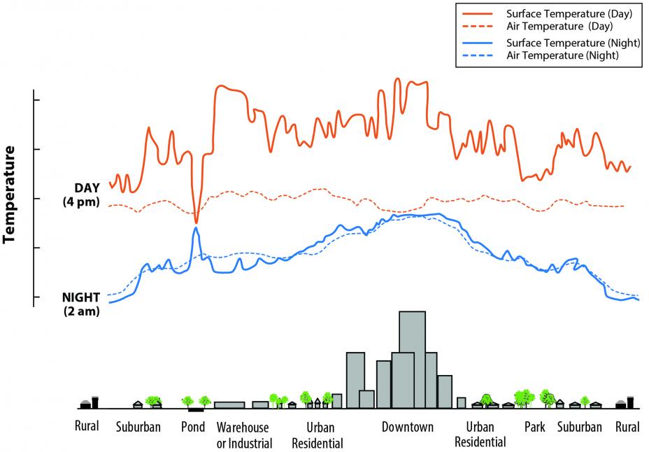
Surface temperatures vary more than atmospheric air temperatures during the day, but they are generally similar at night. The dips and spikes in surface temperatures over the pond area show how water maintains a nearly constant temperature day and night because it does not absorb the sun’s energy the same way as buildings and paved surfaces. Parks, open land, and bodies of water can create cooler areas within a city. Temperatures are typically lower at suburban-rural borders than in downtown areas.
In general, temperatures are different at the surface of the earth and in the atmospheric air, higher above the city. For this reason, there are two types of heat islands: surface heat islands and atmospheric heat islands. These differ in the ways they are formed, the techniques used to identify and measure them, their impacts, and to some degree the methods available to cool them.
- Surface Heat Islands. These heat islands form because urban surfaces such as roadways and rooftops absorb and emit heat to a greater extent than most natural surfaces. On a warm day with a temperature of 91°F, conventional roofing materials may reach as high as 60°F warmer than air temperatures.[2] Surface heat islands tend to be most intense during the day when the sun is shining.
- Atmospheric Heat Islands. These heat islands form as a result of warmer air in urban areas compared to cooler air in outlying areas. Atmospheric heat islands vary much less in intensity than surface heat islands.
Heat Island Impacts
Heat islands can contribute to a range of environmental, energy, economic, and human health impacts. Visit the Heat Island Impacts page for more information.
Reducing Heat Islands
Numerous strategies exist for reducing the severity of the heat island effect. Visit the Heat Island Cooling Strategies page for more information.[1]Hibbard, K.A., F.M. Hoffman, D. Huntzinger, and T.O. West. 2017. Changes in land cover and terrestrial biogeochemistry. In Climate Science Special Report: Fourth National Climate Assessment, Volume I [Wuebbles, D.J., D.W. Fahey, K.A. Hibbard, D.J. Dokken, B.C. Stewart, and T.K. Maycock (eds.)]. U.S. Global Change Research Program, Washington, DC. pp. 277–302. doi: 10.7930/J0416V6X.
[2] Simmons, M.T., B. Gardiner, S. Windhager, and J. Tinsley. 2008. Green roofs are not created equal: The hydrologic and thermal performance of six different extensive green roofs and reflective and non-reflective roofs in a sub-tropical climate. Urban Ecosystems 11:339.