Lower Harbor Confined Aquatic Disposal (CAD) Cell
- CAD Cell Workgroup Meetings
- Technical Workgroup Documents
- CAD Cell Q&A
- Pre-design Historic Data and Investigations
CAD Cell Workgroup Meetings
- April 25, 2012 Meeting Presentations
- Discussion of Potential Air Impacts (PDF) (14 pp, 3.1 MB)
- Overview of Ambient Air PCB Air Monitoring Program (PDF) (6 pp, 1.5 MB)
- CAD Modeling (PDF) (19 pp, 2.6 MB)
- Risk Assessment Presentation (PDF) (11 pp, 1.1 MB)
- April 2, 2012 Meeting Presentations
- Dredging Protocols/Safeguard (PDF) (9 pp, 250 K)
- Dredging and CAD Cell Filling (PDF) (30 pp, 3.1 MB)
- March 2012 Meeting Presentations (PDF) (79 pp, 14.2 MB)
Technical Workgroup Documents
Lower Harbor 2016 Confirmatory Sediment Sampling
December 2016 Technical Workgroup Documents
- December 2016 Updated Lower and Upper Harbor Sampling Data (PDF) (66 pp, 840 K)
- Upper Harbor Dredge Areas Showing Thickness of Sediment to Remove and Core Locations (PDF) (1 pg, 2.9 MB)
Note: Dredge Area map for area between Coggeshall Street and I-195 under development.
July 7, 2015 Meeting Documents
- December 2015 Updated Lower Harbor Sampling Data (PDF) (51 pp, 719 K)
- Lower Harbor Sampling Data (PDF) (59 pp, 559 K)
- Poster 1: Lower Harbor Dredge Areas Showing Thickness of Sediment to Remove and IA/Historical Core Locations (PDF) (1 pg, 3.9 MB)
- Poster 2: Lower Harbor Dredge Areas Showing Thickness of Sediment to Remove and IA/Historical Core Locations (PDF) (1 pg, 3.4 MB)
- Lower Harbor Dredge Areas Locations - Box 1 (PDF) (1 pg, 991 K)
- Lower Harbor Dredge Areas Locations - Box 2 (PDF) (1 pg, 961 K)
- Lower Harbor Dredge Areas Locations - Box 3 (PDF) (1 pg, 1 MB)
- Lower Harbor Dredge Areas Locations - Box 4 (PDF) (1 pg, 1 MB)
- Lower Harbor Dredge Areas Locations - Box 5 (PDF) (1 pg, 984 K)
- Lower Harbor Dredge Areas Locations - Box 6 (PDF) (1 pg, 943 K)
- Lower Harbor Dredge Areas Locations - Box 7 (PDF) (1 pg, 983 KB)
- Lower Harbor Dredge Areas Locations - Box 8 (PDF) (1 pg, 1 MB)
- Lower Harbor Dredge Areas Locations - Box 9 (PDF) (1 pg, 961 K)
- Lower Harbor Dredge Areas Locations - Box 10 (PDF) (1 pg, 998 K)
- Lower Harbor Dredge Areas Locations - Box 11 (PDF) (1 pg, 1.1 MB)
EPA CAD cell docs
- Final Plan for the Sampling of Ambient Air PCB Concentrations During Lower Harbor CAD Cell (LHCC) Construction, October 2013 (PDF) (23 pp, 1.5 MB)
- CAD Cell Specifications, Invitation for Bid 05-13-2013 (PDF) (381 pp, 8.4 MB)
- CAD Cell Specification Drawings, Invitation for Bid, 05-14-2013 (PDF) (15 pp, 31.8 MB)
- EPA Response to Buzzard's Bay Coalition 11/28/2012 Comments on the Invitation for Bid: New Bedford Harbor Development Commission, New Bedford Harbor Lower Harbor CAD Cell (LHCC), March 25, 2013 (PDF) (9 pp, 2.3 MB)
- EPA Responses to Questions Raised by the Buzzards Bay Coalition from 04/25/2012 Meeting of the Technical Working Group Regarding Air Issues, May 22, 2012 (PDF) (15 pp, 2.9 MB)
- Draft Final Lower Harbor CAD Cell Sampling and Analysis Plan, March 2012 (PDF) (1,586 pp, 125.9 MB)
- New Bedford Harbor USEPA Lower Harbor CAD Cell Workplan, December 2011 (PDF) (19 pp, 406 K)
NBH Water Quality Monitoring
- 2009 Toxicity Analysis Report - Biomonitoring of Surface Water Samples from Sampling Event, July 2009 (PDF) (63 pp, 2.3 MB)
- Explanation of New Bedford Harbor Operational Monitoring Approaches, April 24, 2012 (PDF) (5 pp, 657 K)
- Environmental Monitoring of Remedial Dredging at the New Bedford Harbor Superfund Site, December 23, 2004 (PDF) (19 pp, 1.5 MB)
- Development and Use of Site-Specific Chemical and Biological Criteria for Assessing New Bedford Harbor Pilot Dredging Project, 1991 (PDF) (8 pp, 591 K)
New Bedford Harbor Navigational CAD Cells
- SER Navigational Dredging Work Protocols, April 13, 2012 (PDF) (20 pp, 473 K)
- Phase II Water Quality Monitoring Results 01/13/2005 – 07/22/2005 (PDF) (pg 1,779 - pg 1,833 of 2,219 pp, 133 MB)
- Water Quality Monitoring Report Dredge and Disposal Operations Phase II – Part 1 Fish Island Area and Top of CAD Cell, February 28, 2005 (PDF) (9 pp, 504 K)
- Water Quality Monitoring Report Dredge and Disposal Operations Phase II – Part 1 Fish Island Area and Top of CAD Cell, February 5, 2004 (PDF) (10 pp, 523 K)
- Water Quality Monitoring Report Dredge and Cap Placement Operations Phase II – Completion of Initial Construction of CAD Cell and OU3 Cap Placement, July 7, 2005 (PDF) (28 pp, 3.2 MB)
- Water Quality Monitoring Report Dredge and Cap Placement Operations Phase II – Completion of Initial Construction of CAD Cell and OU3 Cap Placement, July 26, 2005 (PDF) (26 pp, 3.3 MB)
- CAD Cell 2 – Top of CAD Water Quality Monitoring Turbidity Measurements, July 8, 2008 (PDF) (1 pg, 230 K)
- Water Quality Monitoring Report Dredge Project Phase II Part 2, January 17, 2006 (PDF) (69 pp, 1.6 MB)
Volumes, Areas and Properties of Sediment by Management Units, NBH Site (2003)
- Volumes, Areas and Properties of Sediment by Management Units, Revision 2, September 12, 2003 (PDF) (118 pp, 16.8 MB)
New Bedford Harbor Air Quality Monitoring
- Air Monitoring Data Status as of January 2016 (PDF) (4 pp, 722 K)
- 2013 - 2014 Ambient Air Monitoring Results for the Lower Harbor Confined Aquatic Disposal (CAD) Cell Construction Phase 1 (PDF) (2 pp, 888 K)
- Air Sampling Results for the Lower Harbor Confined Aquatic Disposal (CAD) Cell Construction Phase 1, February 6, 2014 (PDF) (5 pp, 2.3 MB)
- Draft Final Development of PCB Air Action Levels for the Protection of the Public New Bedford Harbor Superfund Site, December 2001 (PDF) (321 pp, 25.5 MB)
CAD Cell Q&A
Printable version of CAD Cell Fact Sheet (PDF) (2 pp, 1 MB)
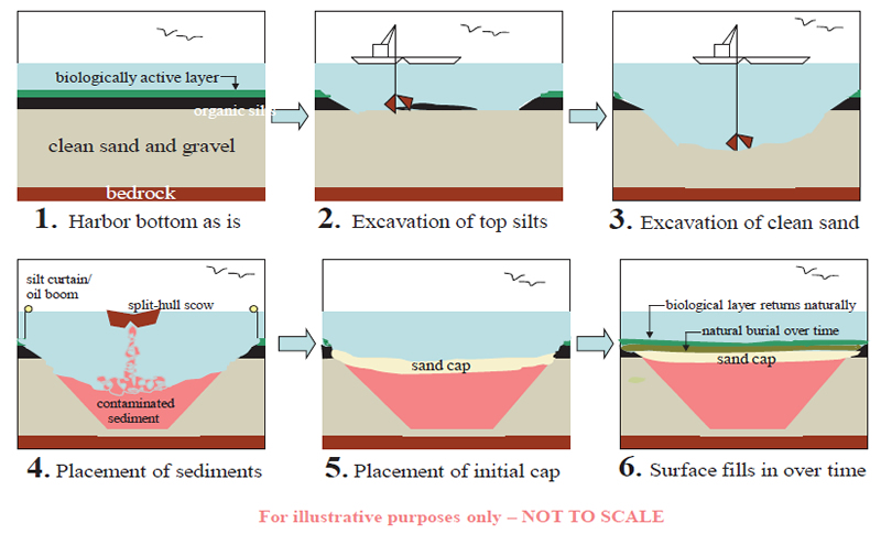
What is a CAD Cell?
The New Bedford Harbor Superfund CAD cell will be a man-made, capped underwater containment cell. First the area for the CAD cell is dug into the harbor floor, excavating the sediment to create the space for the CAD. The original material is excavated and taken to an approved off-shore facility or reused for beneficial uses if appropriate. Contaminated sediment from the harbor will then be placed into the CAD cell, allowed time to consolidate and then capped. The contaminated sediment is held in place by existing clean sediments on the sides and bottom of the cell, and a cap on the top. CAD cells have been used successfully for contaminated navigational sediments in New Bedford as well as many other ports and waterways including Boston and Providence. A simplified schematic of how the CAD cell will be constructed is shown to the right.
When did EPA decide to use a CAD cell?
The decision to build the CAD cell was made in March 2011 by the US EPA after public comment. The CAD cell is being designed now – early in 2012. Construction is expected to begin later in the year. The CAD cell will be located in a state-approved area in New Bedford Harbor between the I-195 and Rt. 6 bridges.
Why has EPA chosen to use a CAD cell in New Bedford Harbor?
The CAD cell will enable completion of the lower harbor cleanup more quickly, and at a lower cost. The CAD cell was selected for the disposal of 300,000 cubic yards of sediment containing between 50-190 ppm of PCBs located mostly in the lower harbor south of the I-195 bridge. These levels are much lower than the levels found in the upper harbor, which range up to four thousand ppm of PCBs.
How long will the CAD cell project take to complete?
The CAD cell is anticipated to be dug beginning this year and completed in 2013. The time and cost to complete the harbor cleanup, including the filling of the CAD cell with contaminated material and the capping of the CAD cell, depends entirely on annual funding appropriations. Keeping in mind the decades-long timeframe that remains for cleanup of the harbor, there can be no guarantee what future funding levels will be.
How much of New Bedford Harbor will be cleaned up as a result of using the CAD cell?
After the CAD cell is filled, more than 80% of the geographic area of (the Upper and Lower Harbor Operable Unit) the New Bedford Harbor Superfund Site requiring cleanup under the Superfund program will be safely disposed of into the CAD cell. Specifically, almost all of the sediment exceeding Superfund cleanup levels located between Sawyer Street to the north and the hurricane barrier to the south (approximately 300,000 cubic yards) will be disposed of into the CAD cell.
How do you know it will be safe to install the CAD cell and keep it sealed?
Data collected and evaluated during the construction of other CAD cells, including in New Bedford, supports EPA's determination that a CAD cell is a safe, permanent solution for disposing of contaminated Harbor sediment. EPA has also conducted computer modeling of potential leakage of contaminants which shows that a CAD cell located in New Bedford Harbor would be stable and not subject to leakage to the environment. EPA will conduct an extensive program of monitoring air, water, and sediment during the project and make the data available to the public. As with any cleanup site, if significant issues arise during design and construction of a remedy, we would re-evaluate the issue(s) to make sure that our remedy protects human health and the environment. EPA does not intend to move forward with any remedy that does not protect the health of New Bedford citizens, or the harbor.
Who is performing the design and construction?
The work is being performed through a cooperative agreement that EPA has signed with the New Bedford Harbor Development Commission (HDC) which has extensive experience with the construction and filling of CAD cells. The HDC has hired APEX Companies, LLC to design and construct the CAD cell. APEX has prior experience designing and overseeing construction of navigational CAD cells in New Bedford Harbor.
How can I get more information about the CAD cell project?
In addition to ongoing community outreach, EPA has funded a "Technical Assistance Grant" or "TAG" to the Buzzard's Bay Coalition. Dr. Frank Bohlen of the Department of Marine Sciences at the University of Connecticut has been hired with TAG funds to review technical information about the project. As part of the EPA decision to design, construct, and fill a CAD cell, a technical workgroup (TWG) open to individuals and organizations interested in the project was formed to review and discuss design and construction documents. Dr. Bohlen will be attending the TWG meetings to provide technical input to the group, address community questions about technical aspects of the project, and provide feedback to EPA.
What are some elements of a TAG?
The TAG program provides money to community groups to pay for technical advisors to interpret and explain technical reports, site conditions, and EPA's current and future cleanup plans
Once EPA has provided the $50,000 grant, it can be used for up to three years with extensions possible if needed and Additional TAG funds may be available. Only one TAG can be given for each Superfund site.
- Confined Aquatic Disposal (CAD) Cell Construction Continues, August 2014 (PDF)(2 pp, 1.3 MB)
- Map of Area North of Route 6 Bridge (PDF)(1 pg, 3.4 MB)
Pre-design Historic Data and Investigations
Lower Harbor Combined Aquatic Disposal (CAD) Cell (LHCC) Data Package Summary Memo (Data Package Attached) (PDF) (2,219 pp, 139.1 MB)
Apex Companies, LLC Cover Memo to Harbor Development Commission
- Memo: Apex Companies, LLC to New Bedford Harbor Development Commission regarding pre-design investigations for the Lower Harbor CAD Cell, February 16, 2012 (PDF) (pg 1 - pg 7 of 2,219 pp, 133 MB)
Harbor Bottom Bathymetry Data
This information outlines the existing bathymetry, measured in feet below Mean Lower Low Water, of the existing bottom of the harbor within the area anticipated to be utilized to construct the LHCC. It includes the following figure, which is a visual representation of the bathymetry:
- Figure 1 – Bathymetric Data Plan, Apex Companies, LLC. (PDF) (pg 8 of 2,219 pp, 133 MB)
Harbor Sediment Boring Data
This information includes both historic and more recent borings, as well as geotechnical analytical data generated from those borings, that have been advanced within the area where the LHCC is being considered to be sited. Geotechnical analytical data is also included that is representative of material to be placed into the LHCC. The data includes the following:
- Historic Boring Logs (PDF) (pg 9 - pg 469 of 2,219 pp, 133 MB)
- Historic Geotechnical Analytical Data (PDF) (pg 470 - pg 730 of 2,219 pp, 133 MB)
- Historic Organic Silt-Clay Hydraulic Conductivity Data (PDF) (pg 731 - pg 740 of 2,219 pp, 133 MB)
- LHCC Boring Logs (PDF) (pg 741 - pg 765 of 2,219 pp, 133 MB)
- Partial LHCC Geotechnical Analytical Data (PDF) (pg 766 - pg 825 of 2,219 pp, 133 MB)
- Figure 2 - Boring Location Plan, Apex Companies, LLC. (PDF) (pg 826 of 2,219 pp, 133 MB)
CAD Cell Pre-design Historical Data
This is historic information that is relevant to the siting and design of the LHCC. It is organized into a number of sub-categories as follows:
Historic Air Evaluations
This information has been provided (along with the New Bedford Superfund Site Risk Assessments) to address concerns by the public regarding the risks associated with concentrations of PCBs in air. It includes the following reports:
- Evaluation of the Impact of Dredging and CAD Cell Disposal on Air Quality, Jacobs Engineering Group, June 2010 (PDF) (pg 827 - pg 883 of 2,219 pp, 133 MB)
Historic New Bedford Harbor Superfund Risk Assessments
This information has been provided to provide a background for the human health and ecological risks associated with PCBs in New Bedford Harbor that drove the 1998 Record of Decision and subsequent Explanations of Significant Differences, including the Lower Harbor CAD Cell.
- Draft Final Baseline Public Health Risk Assessment, EBASCO, August 1989 (PDF) (pg 884 - pg 1,073 of 2,219 pp, 133 MB)
- Draft Final Baseline Ecological Risk Assessment, EBASCO, April 1990 (PDF) (pg 1,074 - pg 1,277 of 2,219 pp, 133 MB)
Historic USEPA LHCC Feasibility Assessments
This information has been provided to outline the assessments USEPA conducted prior to implementing the Explanation of Significant Differences associated with the LHCC.
- Assessment of Contaminant Loss and Sizing for Proposed Lower Harbor Confined Aquatic Disposal (CAD) Cell, USACE Engineer Research and Development Center, May 2010 (PDF) (pg 1,278 - pg 1,539 of 2,219 pp, 133 MB)
- Turbidity Monitoring and Plume Sampling Results for City Dredge Disposal at the New Bedford Harbor CAD Cell #2, Battelle, December 2009 (PDF) (pg 1,540 - pg 1,622 of 2,219 pp, 133 MB)
Historic Background Material and Literature
This information has been provided to outline background information regarding CAD Cells, as well as some background information regarding the mass of PCBs associated with the New Bedford Harbor Superfund Site.
- Estimate of Mass of PCBs in New Bedford Harbor, EBASCO, April 1989 (PDF) (pg 1,623 of 2,219 pp, 133 MB)
- USACE Leaching/Pore Water Analysis (PDF) (pg 1,624 of 2,219 pp, 133 MB)
- Understanding the Physical and Environmental Consequences of Dredged Material Disposal: History in New England and Current Perspectives, Fredette and French, 2004 (PDF) (pg 1,625 - pg 1,634 of 2,219 pp, 133 MB)
- Why Confined Aquatic Disposal Cells Often Make Sense, Fredette, 2005 (PDF) (pg 1,635 - pg 1,638 of 2,219 pp, 133 MB)
Historic Remote Sensing Reports
This information includes remote sensing reports that have been prepared within the area where the LHCC is being considered to be sited:
- Underwater Archeological Remote Sensing Survey, Dolan Research, Inc., January 2000 (Revised March 2001) (PDF) (pg 1,639 - pg 1,695 of 2,219 pp, 133 MB)
- Underwater Archeological and Hazards Analysis, Remote Sensing Survey, Apex Environmental, Inc., March 2003 (PDF) (pg 1,696 - pg 1,768 of 2,219 pp, 133 MB)
Historic Navigational Dredging Water Quality Measurements
This information includes water quality measurements that have been completed associated with the Phase II and Phase III Navigational Dredging program, which included mechanical dredging, and placement of material into CAD Cells.
- Phase II Water Quality Monitoring (PDF) (pg 1,769 - pg 1,833 of 2,219 pp, 133 MB)
- Phase III Water Quality Monitoring (PDF) (pg 1,834 - pg 1,838 of 2,219 pp, 133 MB)
Historic Suspended Sediment Transport Modeling and Measurement
This information includes transport modeling associated with CAD Cell planning associated with the Dredge Material Management Plan process as well as a flux analysis conducted by EPA indicating the quantity of contaminated sediment entering Buzzard's Bay under existing conditions.
- Dredge Material Transport Modeling Analysis, Maguire Group, July 2003 (PDF) (pg 1,839 - pg 1,915 of 2,219 pp, 133 MB)
- New Bedford Harbor PCB Flux Study, Woods Hole Group, Inc., August 2010 (PDF) (pg 1,916 - pg 1,968 of 2,219 pp, 133 MB)
Historic Toxicity Testing
This information includes toxicity testing associated with suspended sediment anticipated to be generated during placement of contaminated material into CAD Cells.
- Task 2A: Suspended Particulate Phase Acute Toxicity Testing with Mysids, Maguire Group, July 2003 (PDF) (pg 1,969 - pg 1,991 of 2,219 pp, 133 MB)
- Task 2B: Toxicity Identification Evaluation Testing with Mysids and Sea Urchins, Maguire Group, July 2003 (PDF) (pg 1,992 - pg 2,044 of 2,219 pp, 133 MB)
Seismic Data
This information includes geophysics reports (seismic and sub-bottom analyses) that have been prepared for the area anticipated to be utilized to construct the LHCC. This information is primarily historic.
- CDF D Geophysics (PDF) (pg 2,045 - pg 2,049 of 2,219 pp, 133 MB)
- Report of Marine Geophysical Surveys: Seismic Refraction, Sub-Aqueous Disposal Cell Feasibility Studies, Apex Environmental, Inc., 2001 (PDF) (pg 2,050 - pg 2,095 of 2,219 pp, 133 MB)
- Addendum To Marine Geophysical Surveys: Seismic Refraction, Sub-Aqueous Disposal Cell Feasibility Studies, Updated Data and Model Revision, Maguire Group, 2003 (PDF) (pg 2,096 - pg 2,135 of 2,219 pp, 133 MB)
Vibracore Data
This information includes vibracores that have been advanced within the area where the LHCC is being considered to be sited. This information is primarily historic. Information to supplement this data is currently being generated, but is not currently available:
- Historic Vibracore Logs (PDF) (pg 2,136 - pg 2,212 of 2,219 pp, 133 MB)
- Figure 3 - Historic Vibracore Location Plan, Apex Companies, LLC (PDF) (pg 2,213 of 2,219 pp, 133 MB)
Conceptual LHCC Siting Plans
These figures have been generated to outline a number of conceptual locations for the proposed LHCC. Once a location has been finalized, final design of the LHCC will begin.
- Figure 4: Conceptual LHCC Location Plan 1: Shows one potential location for the Lower Harbor CAD Cell (PDF) (pg 2,214 of 2,219 pp, 133 MB)
- Figure 5: Conceptual LHCC Location Plan 2: Shows one potential location for the Lower Harbor CAD Cell (PDF) (pg 2,215 of 2,219 pp, 133 MB)
- Figure 6: Conceptual LHCC Location Plan 3: Shows one potential location for the Lower Harbor CAD Cell (PDF) (pg 2,216 of 2,219 pp, 133 MB)
- Figure 7: Conceptual LHCC Location Plan 4: Shows one potential location for the Lower Harbor CAD Cell (PDF) (pg 2,217 of 2,219 pp, 133 MB)
- Figure 8: Conceptual LHCC Location Plan 5: Shows one potential location for the Lower Harbor CAD Cell (PDF) (pg 2,218 of 2,219 pp, 133 MB)
- Figure 9: Conceptual LHCC Location Plan 6: Shows one potential location for the Lower Harbor CAD Cell (PDF) (pg 2,219 of 2,219 pp, 133 MB)
This particular scenario assumes that the LHCC would be combined with a CAD Cell needed for future Navigational Dredging.