Superfund Sites in Reuse in Montana
If you are having trouble viewing the map in your browser, click the 'View larger map' link below
ACM Smelter and Refinery
The 427-acre ACM Smelter and Refinery Superfund site is located in Cascade County, Montana, next to the unincorporated community of Black Eagle. In 1892, the Boston & Montana Consolidated Copper and Silver Mining Company began constructing the first smelter at the site. Operations to concentrate, smelt and refine ore began in 1893. Electrolytic and furnace refineries also operated at the site. In 1910, Anaconda Copper Mining Company acquired the property. Zinc smelting and refining activities continued until the early 1970s. In 1977, Atlantic Richfield Company (AR) purchased the property. Copper refining continued until the plant closed in 1980. Refinery operations contaminated soil, groundwater and surface water around the site. AR implemented a voluntary cleanup of the facility in the 1990s. The site currently provides wildlife habitat and the community is interested in using the site for recreation. The state of Montana requested that EPA conduct a site investigation in 2002. EPA added the site to the National Priorities List (NPL) in 2011. Investigation and cleanup activities are ongoing. Investigations have included sampling in residential yards and along the abandoned railroad. As of 2011, a recycling facility and a golf course remain on part of the site property. A removal action in 2011 cleared the way for a new residential subdivision with the community of Black Eagle.
Last updated September 2019
As of December 2019, EPA did not have economic data related to on-site businesses, or economic data were not applicable due to site use. For additional information click here.
For more information:
Anaconda Aluminum Co. Columbia Falls Reduction Plant
The 960-acre Anaconda Aluminum Co. Columbia Falls Reduction Plant Superfund site is in Columbia Falls, Montana. Aluminum reduction took place on site from 1955 to 2009. The plant stopped operating due to poor economic conditions for aluminum reduction. Spent potliner is a waste product resulting from aluminum reduction. Disposal of this and other wastes at the site has contaminated groundwater. EPA added the site to the National Priorities List (NPL) in 2016. Under an agreement with EPA, Columbia Falls Aluminum Company is investigating site contamination and looking at options for cleanup. Demolition of a portion of the plant began in 2016 and is expected to be completed in 2019. Most of the plant property is unused, except for one open industrial landfill that has been inactive since 2009. Public services on site include a Bonneville Power Administration rectifier yard and switchyard and a Burlington Northern rail line. The current owner of the site is actively marketing the plant site for commercial/industrial development. Anglers frequent the Flathead River, which has received contaminated groundwater discharge from the site and is being evaluated as part of the Baseline Ecological Risk Assessment. The river is a fishery that includes federally recognized endangered fish species. These species include the federally designated threatened bull trout and the federally sensitive west slope cutthroat trout.
Last updated September 2019
As of December 2019, EPA did not have economic data related to on-site businesses, or economic data were not applicable due to site use. For additional information click here.
For more information:
Anaconda Co. Smelter 


 Anaconda Co. SmelterThe Anaconda Co. Smelter Superfund site is a former copper smelter in southwest Montana. The site includes the towns of Anaconda and Opportunity. From 1884 to 1980, the smelter was the cornerstone of the local economy. The smelter closed in 1980. It left behind more than 300 square miles of soil and water contaminated with heavy metals. EPA added the site to the National Priorities List (NPL) in 1983. EPA worked with the community, Atlantic Richfield (AR) (property owners of the former smelting facility), the state of Montana and Anaconda-Deer Lodge County to clean up the site and support its redevelopment. In 1994, AR began turning 250 acres of the site into a 21-hole golf course. The course combines remedy, landscaping and preservation of historic mining artifacts. The golf course opened to the public in 1997. Dozens of new commercial developments have been created on remediated on site properties, including a natural gas power plant, regional prison and a campus of excellence for the disabled. Cleanup has also addressed homes and commercial properties within Anaconda, Opportunity and adjacent areas. Cleanup activities to address arsenic contamination at residential and commercial properties began in 2003. Cleanup to address lead contamination began in 2015. To date, AR has cleaned up more than 1,300 current residential and commercial properties, with cleanup still ongoing. Thousands of acres of agricultural lands have been reclaimed and put back into productive use. Thousands of acres of former waste disposal sites have been capped and now provide wildlife habitat, including nearly 1,000 acres of new wetlands. The remedy has also made 30 million cubic yards of slag material available for reuse. A slag reuse operation provides material for use as abrasives, roofing material and Portland cement. Potential reprocessing of slag is being evaluated to produce pig iron and proppant. EPA’s Superfund Redevelopment Initiative supported a regional seed project at the site in 2005.
Last updated September 2019
As of December 2019, EPA had data on 6 on-site businesses. These businesses employed 86 people and generated an estimated $8,210,857 in annual sales revenue. For additional information click here.
For more information:
Barker Hughesville Mining District
The 6,000-acre Barker Hughesville Mining District Superfund site is located in Judith Basin County and Cascade County in west-central Montana. In 1879, rich silver and lead ores were discovered in the area. Mining took place through the 1940s. Mining activities and abandoned mines contaminated soil, sediment, groundwater and surface water. EPA added the site to the National Priorities List (NPL) in 2001. To date, several short-term cleanup actions have been completed. The site’s long-term cleanup plan is under development. In 2015, Montana Fish, Wildlife & Parks and the U.S. Forest Service placed a fish barrier in Dry Fork Belt Creek as part of an effort to restore native westslope cutthroat trout in the watershed. Groundwater, surface water and sediment sampling are ongoing. About 88 percent of the land area within the site is federally-administered public land. Residential, recreational, agricultural and commercial use of on-site properties is ongoing. In addition, since the 1960s a missile silo has been used within the boundaries of the site. The military also installed an optic fiber cable within the site along Dry Fork Belt Creek.
Last updated September 2019
As of December 2019, EPA did not have economic data related to on-site businesses, or economic data were not applicable due to site use. For additional information click here.
For more information:
Basin Maining Area
The Basin Mining Area Superfund site covers about 77 square miles in Jefferson County, Montana. It includes the town of Basin and about 300 mine sites in the surrounding watersheds of Basin Creek, Cataract Creek and the Boulder River. From the 1870s until the late 1950s, hard-rock mining operations generated waste rock and tailings at the site. Heavy metal from the waste rock and tailings contaminated surface water, soil, sediment, groundwater, air and biota. Following analyses by the Montana Department of Transportation and EPA, EPA added the site to the National Priorities List (NPL) in 1999. EPA dug up and disposed of contaminated residential soil and mine waste. EPA also backfilled and revegetated contaminated areas. Cleanup in the town of Basin finished in the fall of 2004. Land uses in Basin include neighborhoods, commercial areas, public services and recreation areas. Cleanup of the mine sites is ongoing.
Last updated September 2019
As of December 2019, EPA had data on 15 on-site businesses. These businesses employed 54 people and generated an estimated $878,391 in annual sales revenue. For additional information click here.
For more information:
Burlington Northern (Somers Plant)
The 80-acre Burlington Northern (Somers Plant) site is in Somers, Flathead County, Montana. From 1901 to 1986, industrial operations on site included chemical treatment of railroad ties and other lumber products. These activities contaminated beach sediments about 150 feet into Flathead Lake, as well as soil and groundwater. Cleanup included soil and groundwater treatment and replacement of wetlands. Cleanup also included a natural resource damages settlement. BNSF Railway Company (BNSF) completed wetland restoration at the Swamp Pond and acquired 7.5 acres of wetlands near the Water Fowl Production Area on Flathead Lake. BNSF also conveyed a perpetual wetland reserve easement to the U.S. Fish and Wildlife Service. BNSF bought residential properties on the site and demolished structures. This area is currently vacant aside from structures related to cleanup. Efforts to prevent erosion along the north shore of Flathead Lake, which is used for recreational purposes, are ongoing near the site to ensure remedy protectiveness and allow public access to the lake.
Last updated September 2019
As of December 2019, EPA did not have economic data related to on-site businesses, or economic data were not applicable due to site use. For additional information click here.
For more information:
Burlington Northern Livingston Shop Complex
The 90-acre Burlington Northern Livingston Shop Complex (BNLSC) Superfund site is located primarily in Livingston, Montana. In 1883, the Northern Pacific Railroad (NPRR) constructed a rail yard at the site. By the early 1900s, the rail yard had expanded to include a passenger depot, machine shops, a turntable, a roundhouse and a powerhouse. Historical rail yard operations, including waste treatment, storage and disposal practices, contaminated soil and groundwater. The site includes an area of groundwater contamination about 2 miles long and half a mile wide. Facility operations ceased in 1986. Operations resumed a year later when Montana Rail Link (MRL) bought part of the site. MRL currently operates an active rail yard on site with locomotive and rail car repair and maintenance shops. In addition, residential use occurs above the groundwater contaminant plume. Burlington Northern Railroad (now the BNSF Railway Company (BNSF)) began cleanup activities in 1988. Following cleanup, operation and maintenance activities are ongoing. In 2017, EPA removed the BNLSC site from its proposal to the National Priorities List (NPL). Montana Department of Environmental Quality oversees cleanup and is addressing the facility as a state Superfund site. BNSF is considering green remediation practices as part of cleanup. This includes piloting the use of bacteria to help break down groundwater contamination under bedrock in the long term.
Last updated September 2019
As of December 2019, EPA had data on one on-site business. This business employed 65 people and generated an estimated $12,679,000 in annual sales revenue. For additional information click here.
For more information:
Carpenter Snow Creek Mining District
The 9,000-acre Carpenter Snow Creek Mining District Superfund site includes about 96 abandoned mines in the Little Belt Mountains of Cascade County, Montana. Most of the site is located within the Helena-Lewis and Clark National Forest, which has been administered by the U.S. Department of Agriculture Forest Service since the early 1900s. From 1882 to 1929, operators of the Neihart Mining District mined zinc lead ore containing high concentrations of silver. Mining activities ceased after World War II. Mineral extraction and processing left behind mine waste and mining-influenced water on public and private lands. In the early 1990s, the Montana Abandoned Mine Reclamation Bureau found metal concentrations at levels harmful for human health and the environment. EPA added the site to the National Priorities List (NPL) in 2001. EPA selected a cleanup plan for residential soils in the town of Neihart in 2009. Monitoring and site characterization across the watershed are ongoing. EPA is working on additional cleanup plans for the site. Cleanup efforts target surface soils and mining-influenced waters. Major cleanup efforts so far include contaminated soil removal in Neihart and mine tailings removal. Cleanup and monitoring activities are ongoing. The Montana Fish, Wildlife & Parks is in the process of constructing a fish barrier to protect cutthroat trout, a species of concern. The site remains in continued ecological, residential, recreational, public service and commercial use.
Last updated September 2019
As of December 2019, EPA had data on 5 on-site businesses. These businesses employed 21 people and generated an estimated $2,079,391 in annual sales revenue. For additional information click here.
For more information:
East Helena Site 


 East Helena SiteThe East Helena Superfund site is located in East Helena, Montana. The site includes a former lead smelter, the town of East Helena, several residential subdivisions and surrounding agricultural lands. Operated by Asarco, the smelter functioned from 1888 until 2001 and helped to define the community’s heritage. Smelter operations also led to the contamination of large portions of the former smelter facility, East Helena and the surrounding county. EPA placed the site on the National Priorities List (NPL) in 1984. Cleanup efforts began in the early 1990s, when Asarco removed contaminated soil from residential yards in East Helena. Asarco continued these activities through 2010. In 2010, as a result of the Asarco bankruptcy, EPA assumed the residential yard Superfund cleanup. EPA oversees the court-appointed trustee cleanup of the facility. To date, cleanup at the facility has included demolition of facility structures, consolidation and covering of contaminated soil and sediment, treatment of contaminated water, and reconstruction of Prickly Pear Creek’s channel and floodplain. Cleanup activities are ongoing. To support future development, the city of East Helena annexed former Asarco-owned lands outside the city boundary in 2009. The community is now considering future land use, growth and development options. To support the community, EPA and the Montana Environmental Trust Group (trustee for the site after Asarco’s 2009 bankruptcy) have coordinated cleanup planning with local planning and development efforts. In 2011, EPA’s Superfund Redevelopment Initiative also funded a community planning charrette and reuse planning process. The project resulted in a development strategy for East Helena. It focuses on opportunities for economic development and cultural heritage celebration as well as habitat and recreation. Current site uses include residential, agricultural, commercial and industrial uses. A new elementary school now stands on cleaned-up land. Construction for the first East Helena High School began on site in March 2019 and the school is expected to open in 2020. Prickly Pear Creek and surrounding wetlands have been restored.
Last updated September 2019
As of December 2019, EPA had data on 64 on-site businesses. These businesses employed 390 people and generated an estimated $92,547,433 in annual sales revenue. For additional information click here.
For more information:
- Coming to the Table: Community Revitalization in Montana, The East Helena Superfund and RCRA Site in East Helena, Montana (PDF)(16 pp, 14.7 MB)
- East Helena, East Helena, MT - Reuse Plan (PDF) (12 pp, 6.6 MB, About PDF)
- Superfund Site Profile Page
Flat Creek IMM
The Flat Creek IMM Superfund site is located in Superior, Montana. From 1909 to 1930 and again from 1947 to 1953, the Iron Mountain Mine (IMM) operated on site. IMM produced silver, gold, lead, copper and zinc ores. Mine operations produced tailings contaminated with heavy metals. The local government and various individuals imported tailings into Superior to use as fill material in yards, roadways and other locations, including a school track and fairgrounds. In 2000, a forest fire triggered a large runoff event that carried contaminated tailings into and around the Flat Creek Watershed. These operations and events resulted in the contamination of residential areas and other properties as well as the Flat Creek Watershed. The site includes the abandoned IMM mine, Flat Creek and the town of Superior. EPA added the site to the National Priorities List (NPL) in 2009. Cleanup is ongoing. Today, the site remains in continued use. Commercial and residential areas, museums, schools and government offices are located on site.
Last updated September 2019
As of December 2019, EPA had data on 61 on-site businesses. These businesses employed 614 people and generated an estimated $41,843,215 in annual sales revenue. For additional information click here.
For more information:
- Reuse and the Benefit to Community: A Beneficial Effects Economic Case Study for the Flat Creek IMM Superfund Site (PDF)(30 pp, 2.8 MB)
- Superfund Site Profile Page
Idaho Pole Co.
The 75-acre Idaho Pole Co. (IPC) Superfund site is located in Bozeman, Montana. Beginning in 1945, the IPC wood-treating facility began using creosote to preserve wood on site. In 1952, the company switched to pentachlorophenol in carrier oil for the wood-treating solution. IPC stopped treating wood on site in 1997. Facility operations resulted in the contamination of soil and groundwater. EPA placed the site on the National Priorities List (NPL) in 1986. Cleanup included soil and groundwater treatment. Groundwater monitoring is ongoing. IPC owns about 65 acres of the site. A small part of Interstate 90 (the interstate) crosses the site. Residential properties are located on the northern portion of the site. Properties owned by IPC that are not next to the interstate are zoned for rural residential uses. About 41 acres of vacant property south of the interstate and some acreage north of the interstate are ready for industrial or commercial reuse. In April 2019, a parcel on the north side of the interstate was sold and the new owner is in the process of constructing storage units on this parcel. Another 20 acres north of the interstate are ready for residential reuse.
Last updated September 2019
As of December 2019, EPA did not have economic data related to on-site businesses, or economic data were not applicable due to site use. For additional information click here.
For more information:
Libby Asbestos Site
 Libby AsbestosThe Libby Asbestos Superfund site is located in the northwest corner of Montana. It includes the cities of Libby and Troy, highways and railroads. Gold miners discovered vermiculite in Libby in 1881. Mining began in the 1920s and ended in 1990. The W.R. Grace Company most recently owned and operated the mine operations. Vermiculite uses ranged from construction materials, such as insulation and tiles, to soil amendments in gardens and fill for driveways in Lincoln County, Montana. By some estimates, while in operation, the Libby mine may have produced more than 80 percent of the world's supply of vermiculite. Asbestos co-mingled with the vermiculite contaminated the Libby area with multiple pathways for exposure. EPA sent an Emergency Response Team to Libby in 1999 to investigate and begin removing asbestos in the community. Since 1999, EPA has worked with local, state and federal agencies to investigate over 7,600 residential and commercial properties and clean up more than 2,600 of these properties. In 2002, EPA placed the site on the National Priorities List (NPL). EPA has completed cleanup at most properties in Libby and Troy. EPA completed cleanup of the Flyway property and Highway 37 right-of-way (known as operable unit 2, or OU2) in 2012. No additional activities are required at OU2, and Montana Department of Environmental Quality will continue to monitor OU2 regularly to ensure protectiveness at this location. EPA has actively supported economic development and reuse efforts in Libby and Troy. EPA worked with the Lincoln County Port Authority in 2004 and 2017 to support land use planning and reuse efforts for 400 acres of industrial and commercial properties, including the former Stimson Mill property. EPA sponsored meetings on economic revitalization in 2005 that targeted the real estate community and local contractors. EPA collaborated with the city, county and community members on the redevelopment of Riverfront Park. This multi-use facility includes river access, pavilions, a memorial, parking, picnic tables and fishing areas. The park also hosts Libby’s annual Riverfront Blues Festival. With EPA’s mission to protect human health and the environment in mind, EPA established the Superfund Task Force in May 2017 to provide recommendations for improving and expediting site cleanups and promoting redevelopment. Based on the Superfund Task Force recommendations, EPA identified the site as a Redevelopment Opportunity site – a site with the greatest expected redevelopment potential. EPA hosted an initial visioning session in 2017 with property owners and key stakeholders to discuss a long-term vision for redevelopment of the Kootenai Business Park resulting in a redevelopment implementation framework to support more industrial and commercial businesses, as well as more recreation opportunities. EPA’s Superfund Redevelopment Initiative supported a regional seed project at the site in 2018 to develop video material to highlight reuse efforts at the Libby Asbestos and Libby Groundwater Superfund sites. On November 29, 2018, EPA presented an Excellence in Site Reuse Award to the city of Libby and other stakeholders for the cleanup and redevelopment of Operable Unit 1 (Former Export Plant), now Riverfront Park. EPA also worked with the community to clean up a golf course and support development of a recreational trail and fishing pond. In 2019, EPA and the Montana Department of Environmental Quality deleted OU2 from the NPL. EPA conducts five-year reviews of all operable units at the site; the next five-year review is anticipated in 2020.
Last updated September 2019
As of December 2019, EPA had data on 10 on-site businesses. These businesses employed 75 people and generated an estimated $11,796,000 in annual sales revenue. For additional information click here.
For more information:
- Recreational and Ecological Use at Superfund Sites Story MapEXIT
- Pride and Perseverance: Community Engagement and EPA Cleanup of the Libby Asbestos Superfund Site (Video) Exit
- Libby Reuse Planning Summary (PDF) (4 pp, 5 MB)
- Out of the Dust: Recreational Reuse After Vermiculite Mining at the Libby Asbestos Superfund Site in Libby, Montana (PDF) (18 pp, 2.8 MB, About PDF)
- Superfund Site Profile Page
Libby Ground Water Contamination
The Libby Groundwater Superfund site is located on the eastern edge of Libby, Montana. The site’s groundwater contamination plume underlays parts of the city of Libby and county land, including land owned by the Lincoln County Port Authority (Kootenai Business Park). The site was part of a lumber and plywood mill, which treated wood on site between 1946 and 1969. In 1979, investigations discovered well water contamination at a nearby residence. EPA placed the site on the National Priorities List (NPL) in 1983. Cleanup began in 1986 and is ongoing. Cleanup activities have included connecting residents to the municipal water supply, well closures and payments to owners, institutional controls, and soil and groundwater treatment. The site currently supports recreational, residential, commercial and light industrial uses. Beginning in 2016, the Superfund Redevelopment Initiative supported reuse planning efforts at the site through a regional seed project. With EPA’s mission to protect human health and the environment in mind, EPA established the Superfund Task Force in May 2017 to provide recommendations for improving and expediting site cleanups and promoting redevelopment. Based on the Superfund Task Force recommendations, EPA identified the site as a Redevelopment Opportunity site – a site with the greatest expected redevelopment potential.
Last updated September 2019
As of December 2019, EPA did not have economic data related to on-site businesses, or economic data were not applicable due to site use. For additional information click here.
For more information:
Lockwood Solvent Ground Water Plume
The 580-acre Lockwood Solvent Ground Water Plume Superfund site is in Billings, Montana. In 1986, sampling found benzene and chlorinated solvents in water supply wells. Investigations identified an area of groundwater contamination originating from Beall Trailers of Montana and Soco West (formerly Brenntag West). The Beall Trailers facility made and repaired tanker-truck trailers used to transport asphalt. From 1978 to 1990, operators cleaned trailers with industrial solvents and steam prior to maintenance or repair. Wastewater discharged to a septic system drain field on site. Soco West operated a chemical repackaging and distribution company on site. Operations at both facilities resulted in the contamination of soil and groundwater. EPA added the site to the National Priorities List (NPL) in 2000. Cleanup includes groundwater monitoring and soil and groundwater treatment. Groundwater treatment includes using enhanced natural processes to break down site contamination. The site remains in continued use. Residential, commercial and industrial areas are located on site. A small part of Interstate 90 crosses the site.
Last updated September 2019
As of December 2019, EPA had data on one on-site business. This business employed 5 people and generated an estimated $1,400,000 in annual sales revenue. For additional information click here.
For more information:
Milltown Reservoir/Clark Fork River
 Milltown Reservoir/Clark Fork RiverThe Milltown Reservoir Sediments Superfund site is in Milltown, Montana. From the 1860s until the late 20th century, the Clark Fork and Blackfoot Rivers region in western Montana was one of the richest mining regions in the world. Mining operations left behind large areas of mining waste and contamination. EPA added the site to the National Priorities List (NPL) in 1983. The site includes about 120 miles of the Clark Fork River upstream of the Milltown Dam and Reservoir. Cleanup included sediment removal to restore drinking water, removal of the historic Milltown Dam in 2010, and revegetation of a restored floodplain. Cleanup of the Clark Fork River area is currently underway. Cleanup consists of removal of contamination and revegetation of the floodplain channel. Throughout the project, EPA worked with local communities, the state of Montana (the State), and federal and tribal partners to link the cleanup with restoration and redevelopment efforts. In 2005, assisted by an EPA Superfund Redevelopment pilot grant and EPA support, area communities developed a reuse plan for the Milltown Reservoir area. It called for the creation of a state park with trails, river access, wildlife habitat and interpretive areas celebrating the region’s history and heritage. In 2010, the State acquired parts of the site for the new Milltown State Park. The State allocated funding for the park’s development and land acquisitions. The new Milltown State Park fully opened to the public in 2018. Land uses in the Milltown Reservoir Sediments area of the site remain recreational, ecological and agricultural. In 2005, the Clark Fork Coalition also began managing a sustainable cattle ranch on the Clark Fork River part of the site. In 2011 and 2012, EPA and the State restored the ranch area floodplain to a naturally functioning, self-sustaining river ecosystem. Land use in the Clark Fork River area of the site remains residential, recreational and agricultural. Site stakeholders will continue to monitor the Milltown drinking water supply, the area fishery and Clark Fork River floodplain vegetation.
Last updated September 2019
As of December 2019, EPA did not have economic data related to on-site businesses, or economic data were not applicable due to site use. For additional information click here.
For more information:
- Redevelopment of the Milltown Reservoir/Clark Fork River Superfund Site (PDF)(1 pg, 722 K, About PDF)
- Integrating the "3 Rs": Remediation, Restoration and Redevelopment- The Milltown Reservoir Sediments Site and Missoula County, Montana (PDF)(14 pp, 2.3 MB)
- Superfund Site Profile Page
- Video: Reclaiming Recreational Opportunities through the Reuse of Superfund Sites (Multiple projects are features. Milltown 2:58-4:18)
- Video: Sustainability in Region 8: Milltown River Restoration
Montana Pole and Treating
The 40-acre Montana Pole and Treating Superfund site is in Butte, Montana. The site is next to the Silver Bow Creek/Butte Area Superfund site, which has different contaminants of concern. From 1946 to 1983, a wood treatment facility preserved utility poles, posts and bridge timbers on site. Former operations and waste disposal practices contaminated groundwater, surface water, sediment and soil at the site. EPA added the site to the National Priorities List (NPL) in 1987. Cleanup included land treatment of contaminated soil and sediment, expansion of the existing water treatment plant, and moving of sewer and drinking water pipes. The site is divided into two work areas by an interstate highway that crosses the site. The state continues to operate the water treatment plant on the northern part of the site. Reuse options for the southern part of the site will be explored once the final cleanup design is complete.
Last updated September 2019
As of December 2019, EPA did not have economic data related to on-site businesses, or economic data were not applicable due to site use. For additional information click here.
For more information:
Mouat Industries
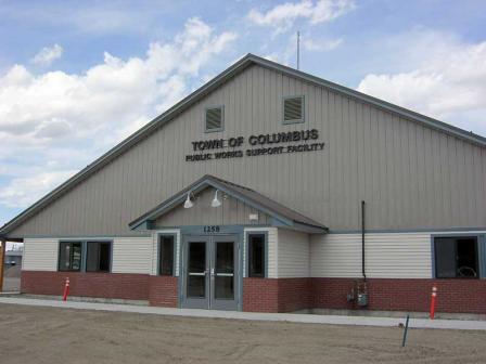 Mouat IndustriesThe 4.5-acre Mouat Industries Superfund site is in Columbus, Montana. The site lies within the historic floodplain of the Yellowstone River. From 1957 to 1962, Mouat Industries’ chromite ore operation was active on site. It generated wastes that contaminated soil and groundwater. EPA added the site to the National Priorities List (NPL) in 1986. Working with EPA, several potentially responsible parties (PRPs) treated contaminated soil and groundwater and implemented groundwater and land use controls. Cleanup construction finished in 1996. In 2009, EPA removed the surface and subsurface soil areas of the site from the NPL. In 2011, the town of Columbus built a new public works building on part of the site. The remainder of the site has a vegetated cap, gravel cover or is the former location of Timberweld, a wood manufacturing company that closed in 2015. The Timberweld assets, including the property, were auctioned in March 2017. One parcel was purchased by a fencing company for the storage of supplies and materials. A second parcel was purchased by a steel workers union, which is currently building a union hall. EPA is working with the new property owners to support appropriate redevelopment considering the remedy in place.
Last updated September 2019
As of December 2019, EPA had data on one on-site business. EPA did not have further economic details related to this business. For additional information click here.
For more information:
Silver Bow Creek/Butte Area
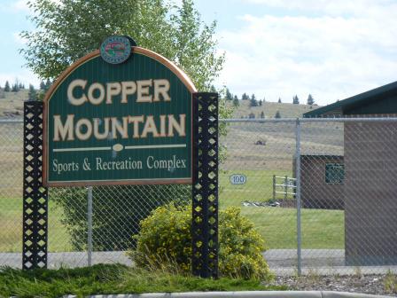 Silver Bow Creek/Butte AreaThe Silver Bow Creek/Butte Area Superfund site starts in Butte, Montana, and runs west about 26 miles near Anaconda. The history of the site dates to the late 1800s, when miners dumped wastes into streams and wetlands near mining operations. This dumping severely polluted Silver Bow Creek and surrounding areas. As a result, EPA placed the site on the National Priorities List (NPL) in 1983. Working together, EPA, Montana Department of Environmental Quality, the site’s potentially responsible parties (PRPs) and the community are returning the site property to productive use. Redevelopment is compatible with the remedy to make sure the cleanup is effective. Redevelopment is also consistent with local goals. The PRPs remove or manage contamination, then areas are capped and revegetated to create amenities like parks and recreational fields. Cleanup also restores waterways and wetlands that provide key habitat for trout, osprey and migrating Canada geese. The Butte Natural Resource Damage (NRD) Restoration Council approved funds for the purchase and planting of trees in the new community park area on the site. Park trails now run through the site. The trails link a system of historic preservation sites in Butte and Walkerville called Montana’s Copperway. Park features include a sports complex with youth baseball fields, a driving range and golf course, walking trails with interpretive signs and stations, public restrooms and picnic areas. Restoration efforts are historic, such as the Granite Mountain Memorial area dedicated to the 168 men who lost their lives in the deadliest underground mining fire in U.S. history. The Memorial also remembers thousands more who died in the Butte area mines. Restoration efforts are also creative, such as the Butte Hill Trail walking path that uses an abandoned railroad bed.
Last updated September 2019
As of December 2019, EPA had data on 329 on-site businesses. These businesses employed 4,628 people and generated an estimated $784,832,091 in annual sales revenue. For additional information click here.
For more information:
- Silver Bow Superfund Site - Before and After Swiper MapExit
- Building on Mining History: Cleanup, Reuse and Community Resilience at the Silver Bow Creek/Butte Area Superfund Site in Butte, Montana (PDF)(17 pp, 6.0 MB, About PDF)
- Superfund Site Profile Page
Smurfit-Stone Mill Frenchtown
The 3,200-acre Smurfit-Stone Mill Frenchtown Superfund site is located 11 miles northwest of Missoula, Montana. A pulp and paper mill began operating on site in 1957. The mill later produced paper and cardboard boxes. The mill filed for bankruptcy in 2009 and closed in 2010. Mill-related chemicals and wastes have contaminated groundwater and surface water. O’Keefe Creek and Clark Fork River are located next to the site; both contain large areas of wetlands. The Clark Fork River is a fishery that supports a variety of finfish, some for human consumption. The river is inhabited by the federally designated threatened bull trout. The segment of the Clark Fork River next to the site is listed as a Wildlife Protected Area for bald eagle nesting territory, a high-density bald eagle winter concentration area, a big game critical wintering/spring area and a historical peregrine falcon nesting area. The site also lies within the Clark Fork River – Grass Valley Important Bird Area, designated due to its significance to bird species of conservation concern. About 1,200 acres of the site remain in agricultural use for cattle grazing and growing alfalfa and grain crops.
Last updated September 2019
As of December 2019, EPA did not have economic data related to on-site businesses, or economic data were not applicable due to site use. For additional information click here.
For more information:
Upper Tenmile Creek Mining Area
The Upper Tenmile Creek Mining Area Superfund site covers about 53 square miles in Lewis and Clark County, Montana. The site consists of about 150 mines in the historic Rimini Mining District, of which 70 of the mines qualified for remedial action and are known as priority mines. Metals mining began in the 1870s and continued through the 1930s. Mine waste rock containing heavy metals contaminated soil, groundwater and surface water. Mine adit discharge is a high-priority concern; the city of Helena (City) obtains about 85 percent of its drinking water supply from the Tenmile Creek watershed. In 1999, EPA added the site to the National Priorities List (NPL). From 1996 to 2001, EPA assisted state agencies in relocating mine waste from several abandoned mines to the Luttrell Repository. The repository is a central location designed to properly handle mine waste. EPA selected the cleanup plan for residential properties in the Rimini and Landmark subdivisions in 2002. EPA revised the cleanup plan for these subdivisions in 2008 to require individual septic systems and prevent future drinking water systems from using groundwater due to the inability to locate a groundwater source with contaminates of concern below MCLs. Thus, EPA identified surface water as the source for a future drinking water supply. In 2002, EPA’s Superfund Redevelopment Initiative supported the City and Lewis & Clark County’s community-based planning process to develop future land use recommendations for the site. In 2003, EPA also provided funding to Rimini Community, Inc., to obtain independent technical assistance though a Technical Assistance Grant. In 2016, EPA completed the residential soils remediation project for properties for which access was obtained (98 percent of the properties identified for remediation) in the Rimini Community and Landmark Subdivision. Investigation for any potential new properties qualifying for remediation along with pursuit of institutional controls via a cooperative agreement with Lewis & Clark County will be pursued to ensure remedy protectiveness. The remediation of unpaved roads in residential areas finished in 2011. EPA has completed remediation of the contaminated mine waste solid media from the Lee Mountain – Little Lily Mine Complex located in the Rimini community. In 2017, remediation of accessible solid-media mine waste from the National Extension and Bunker Hill Priority Mine Group (15 of the priority mine waste sites) finished. At the Rimini Road (Basin Creek Mine Road) area of the site, EPA completed cleanup in 2010. Future planned remedial action at the Priority Mine Waste area of the site includes Rimini Area Adit Discharges, National Extension Adit Discharge, Bunker Hill Source Discharges, Monitor Creek Tailings and Source Discharges, the Ruby/Banner Creek Priority Mine Group, and the Red Mountain Priority Mine Group. Relocation of additional waste to the Luttrell Repository and reclamation of excavated areas will also take place. EPA is working with Lewis & Clark County and the state to establish rules for groundwater use and put institutional controls in place to make sure the site’s future use is compatible with the remedy. EPA is also working on remedial designs for other areas of the site. Current site uses include the community of Rimini as well as recreation in the large undeveloped areas of site. In addition, surface water from Tenmile creek is used for flood irrigation of hay and other crops.
Last updated September 2019
As of December 2019, EPA did not have economic data related to on-site businesses, or economic data were not applicable due to site use. For additional information click here.
For more information: