Superfund Sites in Reuse in Oregon
If you are having trouble viewing the map in your browser, click the 'View larger map' link below
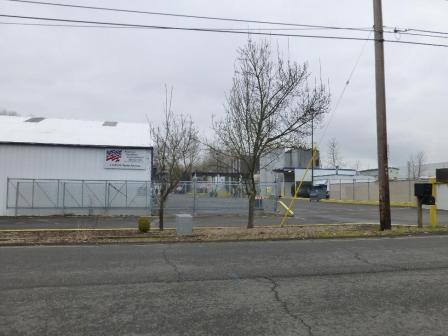
Allied Plating, Inc.
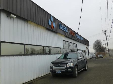 Allied Plating, Inc.The 12-acre Allied Plating, Inc. Superfund site is located in Portland, Oregon. On-site plating activities led to heavy metal and cyanide contamination of groundwater, surface water and soil. EPA added the site to the National Priorities List (NPL) in 1990. In 1992, EPA removed contaminated soil and sludge from the site and treated and disposed of the material in an off-site landfill. EPA then backfilled a low-lying area of the site with rock. In 1993, EPA completed cleanup actions and required placement of a restriction on the property deed to prevent future groundwater use. EPA took the site off the NPL in 1994. A company that makes and installs fire prevention sprinkler systems and a produce distributor currently operate on site. A hauling company uses the site for storage and vehicle parking. Part of the site is used for truck storage.
Last updated September 2019
As of December 2019, EPA had data on 2 on-site businesses. These businesses employed 29 people and generated an estimated $4,859,000 in annual sales revenue. For additional information click here.
For more information:
Black Butte Mine
The Black Butte Mine Superfund site is located near Cottage Grove, Oregon. From the late 1880s to the late 1960s, mercury mining operations and improper waste disposal practices contaminated soil, sediment, surface water and groundwater at the site with metals. EPA placed the site on the National Priorities List (NPL) in 2010. EPA is assessing the nature and extent of site contamination, conducting a risk assessment, and evaluating potential cleanup options. EPA conducted a non-time critical removal action in the furnace creek area in 2018 to address an area where mercury-contaminated wastes were eroding and entering downstream waters. A timber company purchased the site property in 1990. The site property now supports wildlife habitat. After cleanup, the site will also support timber harvesting.
Last updated September 2019
As of December 2019, EPA did not have economic data related to on-site businesses, or economic data were not applicable due to site use. For additional information click here.
For more information:
Grant Warehouse Removal
The Grant Warehouse removal site is located in Portland, Oregon. From 1980 to 1998, the site owner recovered precious metals from ore, liquids and process wastes from other facilities on site. In 1998, Portland Police responded to a dispute on site and found chemical and waste containers stacked wall-to-wall in the building and yard. Cleanup activities included demolition of the building, and removal of all loose and containerized hazardous materials. The Portland Development Commission and Portland Community Reinvestment Initiative worked with EPA and the Oregon Department of Environmental Quality on the property’s redevelopment as a mixed-use commercial and residential building. In November 2018, the Beatrice Morrow Cannady Building held a grand opening celebration.
Last updated September 2019
As of December 2019, EPA had data on one on-site business. EPA did not have further economic details related to this business. For additional information click here.
For more information:
Harbor Oil Inc.
 Harbor Oil Inc.The 4.2-acre Harbor Oil Inc. Superfund site is located in Portland, Oregon. The site is in an industrial area next to Force Lake. Since 1961, Harbor Oil has been recycling used oil on the site. In October 1979, a fire destroyed the facility and ruptured aboveground tanks storing used oil. Used oil and waste paint flowed across the site into nearby wetlands and Force Lake. EPA placed the site on the National Priorities List (NPL) in 2003. Site investigations found that site contamination does not pose an unacceptable risk to human health or the environment. EPA took the site off the NPL in 2014. Several commercial businesses also operate on site.
Last updated September 2019
As of December 2019, EPA had data on 3 on-site businesses. These businesses employed 29 people and generated an estimated $41,394,000 in annual sales revenue. For additional information click here.
For more information:
Joseph Forest Products
The 18-acre Joseph Forest Products Superfund site is located near Joseph, Oregon. A wood-treating facility operated on site from 1974 to 1985. Contamination resulted from poor management practices and a fire. The fire destroyed the treatment building and released wood treatment solution into the soil. EPA placed the site on the National Priorities List (NPL) in 1989. Arsenic, lead and other heavy metals required cleanup. EPA removed tons of contaminated soil and debris, placed restrictions on land use and monitored groundwater for three years. EPA took the site off the NPL in 1999. A resident living on an adjacent property uses the site as a cow pasture.
Last updated September 2019
As of December 2019, EPA did not have economic data related to on-site businesses, or economic data were not applicable due to site use. For additional information click here.
For more information:
McCormick & Baxter Creosoting Co. (Portland Plant) 
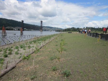
 McCormick & Baxter Creosoting Co. (Portland Plant)The McCormick & Baxter Creosoting Co. Superfund site is located on the Willamette River in Portland, Oregon. The site area includes a 43-acre upland facility and 23 acres of sediment in the Willamette River. From 1944 to 1991, various wood treatment operations occurred on site. From 1950 to 1965, waste oil containing creosote and/or PCP was applied to the site soil for dust suppression in the central processing area. Liquid process wastes were reportedly discharged to a low area near the tank farm prior to 1971. From 1968 to at least 1973, residues from the retorts, oil/water separator, and evaporators were disposed of on site in the former waste disposal area in the western portion of the site. The site included a wastewater discharge outfall that was used to discharge cooling water and contact wastewater to the river when the plant was operating. Two major creosote spills occurred in 1950 and 1956 within and near the tank farm area. Wood treating activities ended in 1991. The Oregon Department of Environmental Quality (ODEQ) concluded that wood treating operations resulted in contaminated site soils, groundwater and river sediments. EPA added the site to the National Priorities List (NPL) in 1994. Under an agreement with EPA, ODEQ cleaned up the site with EPA oversight. ODEQ removed and disposed of wood-treating wastes and contaminated soils, demolished and removed on-site buildings and constructed a soil cap over the upland portion of the site. ODEQ also installed a subsurface barrier wall around the contamination and collected and treated contaminated groundwater until 2011. In 2004, ODEQ completed construction of a 23-acre sediment cap that continues to protect the Willamette River, which is an ecological and recreational feature in the heart of Portland. EPA and ODEQ continue to monitor the soil and sediment caps and the subsurface barrier wall. Even before cleanup reached completion, interested parties began looking at potential redevelopment opportunities for the riverfront site. In 2001, the city of Portland Bureau of Planning and Sustainability, under a grant from EPA, conducted a site reuse assessment. The assessment, endorsed by the Portland City Council, clarified that likely future reuse includes passive and active recreational use. University of Portland’s 2013 Master Plan includes the possibility of obtaining the property for future redevelopment, primarily associated with athletic fields and other, similar land use. In 2018, EPA’s Superfund Redevelopment Initiative began supporting a regional seed project to assist in facilitating reuse discussions, including evaluation of long-term site ownership and stewardship options. During cleanup, ODEQ revegetated the former facility area with native plant species that prevent erosion. Cottonwoods, willows and spiraea now cover the riverbanks as well. Additional institutional controls will be completed for this site. With EPA’s mission to protect human health and the environment in mind, EPA established the Superfund Task Force in May 2017 to provide recommendations for improving and expediting site cleanups and promoting redevelopment. Based on the Superfund Task Force recommendations, EPA identified the site as a Redevelopment Opportunity site – a site with the greatest expected redevelopment potential.
Last updated September 2019
As of December 2019, EPA did not have economic data related to on-site businesses, or economic data were not applicable due to site use. For additional information click here.
For more information:
North Ridge Estates 
The North Ridge Estates Superfund site is located in Klamath Falls, Oregon. The site spans about 170 acres of residential properties. A large portion of the site formerly contained barracks for the U.S. Navy. After the barracks closed in 1946, the site changed ownership for different uses. Eventually, parties demolished buildings on site and began construction of a residential subdivision. Due to improper demolition practices, asbestos from demolished buildings was buried on site and contaminated soils. In January 2006, the developer entered a consent decree to permanently relocate the majority of the residents. Some residents declined relocation and continued to live on site. EPA added the site to the National Priorities List (NPL) in 2011. EPA first responded to the site in 2003, prior to the site listing as an emergency response. Since the initial response, EPA has removed 400,000 cubic yards of asbestos-containing materials from properties in the North Ridge Estates Development. The goal for the cleanup is to restore the site to productive use as a residential neighborhood for the Klamath Falls community. Klamath Tribe cultural monitors worked for EPA’s construction contractor during the cleanup in order to preserve artifacts of historic and cultural significance. Starting in 2013, EPA’s Superfund Redevelopment Initiative (SRI) supported reuse planning for the site. SRI supported the development of a document with renderings to illustrate how site properties are anticipated to look following cleanup. The renderings showed how the neighborhood will look after removal of over 900 ponderosa pines and helped the residents and potential buyers visualize the cleanup process and changes to the landscape during the cleanup process. The document also shared proposed planting plans based on facilitated discussions with residents. In 2015, EPA finalized a cleanup design to remove between 2 and 4 feet of contaminated soils from privately-owned properties and replace with clean soil. The plan for the cleanup spanned over three construction seasons from 2016 to 2018, generally between May and October when the weather is favorable for construction. EPA completed excavation, clean fill placement, and revegetation in November 2018. The cleanup has returned the site to productive use as a residential neighborhood. Over half of the homes have been sold and reoccupied with the remaining homes expected to be sold in 2019. Oregon Department of Environmental Quality will be responsible for operations and maintenance when the restoration is completed in 2019.
Last updated September 2019
As of December 2019, EPA did not have economic data related to on-site businesses, or economic data were not applicable due to site use. For additional information click here.
For more information:
- Superfund Site Profile Page
- Reuse and the Benefit to Community: North Ridge Estates Superfund Site(13 pp, 2.2 MB)
- Redevelopment of the North Ridge Estates, Operable Unit 1 Superfund Site (PDF)(3 pp, 1.6 MB)
- Superfund Job Training Initiative: Making a Difference at the North Ridge Estates Superfund Site in 2016 (PDF)(4 pp, 5 MB)
- Superfund Job Training Initiative: Making a Difference at the North Ridge Estates Superfund Site in 2017 (PDF)(4 pp, 4 MB)
- Video: Protecting Cultural Resources at an Oregon Superfund Site
Northwest Pipe & Casing/Hall Process Company 
 Northwest Pipe & Casing/Hall Process CompanyThe 53-acre Northwest Pipe & Casing/Hall Process Company Superfund site is zoned for light industrial and commercial purposes and is located in Clackamas, Oregon. Operators conducted pipe manufacturing and coating operations at the site from 1956 to 1985. Improper waste disposal activities resulted in the contamination of surface water, soil and groundwater. EPA listed the site on the National Priorities List (NPL) in 1992. Site cleanup included demolition and removal of all site infrastructure, removal and off-site disposal of contaminated soils, and placement of a 2-foot clean soil cap over contaminated areas of soil. EPA also treated contaminated groundwater on site and put land and groundwater use restrictions in place. Groundwater monitoring continues. The site consists of two parcels: Parcel A, which consists of an 11-acre western lot and a 9-acre eastern lot, and the 30-acre Parcel B. The Oregon Department of Transportation (ODOT) owns the 11-acre western lot of Parcel A. ODOT operates a warehouse, office space, equipment yard, and greenhouse and plant nursery on the lot. An automated card-lock fueling station is also located in the western end of the equipment yard. The Northwest Development Corporation owns the 9-acre eastern lot of Parcel A. The Clackamas Commerce Park occupies the lot, which consists of three warehouse/office spaces and associated parking lots. Clackamas County Development Agency purchased Parcel B in 2005. In 2009, the development agency leased the parcel to Oregon Iron Works/Vigor, which completed a laydown yard in the northeast corner of Parcel B in fall 2009. In summer 2010, Oregon Iron Works completed construction of a streetcar test track and maintenance facility on the southern half of Parcel B. ODOT has also extended two roads across the capped area of the site. The highway project, completed in 2016, is part of the Sunrise Corridor Project and helps relieve regional traffic congestion. Minuteman Way, which runs along the western part of the site, has enhanced area infrastructure and includes bike lanes and sidewalks.
Last updated September 2019
As of December 2019, EPA had data on 8 on-site businesses. These businesses employed 244 people and generated an estimated $35,377,000 in annual sales revenue. For additional information click here.
For more information:
- Reuse and the Benefit to Community: Northwest Pipe & Casing/Hall Process Company Case Study (2015) (PDF)(10 pp, 1.1 MB, About PDF)
- Superfund Site Profile Page
Portland Harbor
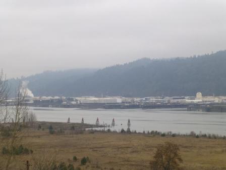
 Portland HarborThe Portland Harbor Superfund Site is located in Portland, Oregon. The cleanup area includes a 10-mile stretch of the lower Willamette River known as Portland Harbor and associated upland source properties. For over 150 years, Portland Harbor has served as an international port for commerce. Surrounding properties have supported manufacturing, shipbuilding, petroleum, metal salvaging and power-generation activities. These industrial uses resulted in contamination of river water and sediment and upland soil and groundwater at riverfront properties. In 2000, EPA placed the site on the National Priorities List (NPL). In 2017, EPA selected a final cleanup plan. The plan includes cleanup of about 394 acres of contaminated sediments and about 23,305 feet of river bank. The $1.05-billion plan includes dredging, capping, enhanced natural recovery, monitored natural recovery, and about 60 acres of compensatory habitat credits, which highlight reuse potential for the site. Some reuse projects are already underway. The Port of Portland owns Terminal 4, an active 262-acre multi-purpose facility on site. The Port plans to revitalize the existing seven berths to handle a wide range of cargoes. Through a Bona Fide Prospective Purchaser Doing Work Agreement with EPA, the University of Portland purchased the 35-acre Triangle Park area of the site in 2008. The University cleaned up the area with EPA oversight. This preliminary work ensured that activities remain consistent with long-term cleanup goals for the site. The University anticipates that the transformed property will provide housing and athletic fields. A trail could also provide public access to the Willamette River waterfront. A habitat development and land management company is developing a restoration project at Alder Creek on Sauvie Island. This includes removal of a 32-acre sawmill complex and restoration of the area using riparian, channel, tidal marsh and mud flat habitats. The project’s goal is to create natural resource credits as a mechanism for environmental damage compensation. Lastly, EPA’s settlement work paved the way for the current Linnton Mill Restoration Site Mitigation Bank project, whereby Linnton Water Credits will make restoration credits available for responsible parties to address their Natural Resource Damages (NRD) liability. The credits associated with NRD liability are being managed by the Portland Harbor Natural Resources Trustee Council. This project also provides habitat credits to responsible parties seeking to offset adverse impacts to aquatic habitat. The site is currently used for industrial and commercial purposes. A federal navigation channel extends from the confluence of the lower Willamette River with the Columbia River to river mile 11.6. Invertebrates, fish, birds, amphibians, and mammals, including some protected by the Endangered Species Act, use habitats within and along the river. The river is also an important pathway for migration of fish such as salmon and lamprey. Various recreational fisheries, including salmon, bass, sturgeon, crayfish, and others, use the lower Willamette River. Resident fish in the site area include but are not limited to: smallmouth bass, brown bullhead, black crappie and carp. The Willamette River is also important to many tribes, and the Siletz, Grand Ronde, Umatilla, Warm Springs, Nez Perce and Yakama Tribes are actively involved in the cleanup oversight effort. Fish are among the resources most frequently used by the tribes in the Portland Basin and the Willamette Valley. Native plants were and continue to be gathered for food and medicinal purposes as well. Tribes have reserved hunting, fishing (particularly salmon and sturgeon) and certain gathering rights through treaties with the United States. These activities provide food for Tribal families and cultural heritage knowledge and skills.
Last updated September 2019
As of December 2019, EPA had data on 63 on-site businesses. These businesses employed 5,210 people and generated an estimated $1,484,095,821 in annual sales revenue. For additional information click here.
For more information:
Reynolds Metals Company
 Reynolds Metals CompanyThe Reynolds Metals Company Superfund site is located 20 miles from Portland, Oregon, outside the city of Troutdale. The site includes an 80-acre former aluminum smelter plant and about 700 surrounding acres. Investigations found contaminated groundwater, surface water, sediments and soils on site. EPA placed the site on the National Priorities List (NPL) in 1994. From 1995 to 2008, Reynolds Metal Company completed most cleanup actions at the site. In 2000, Alcoa purchased and proceeded to close the plant. Alcoa demolished all plant buildings and sold the 700-acre site to the Port of Portland in 2007. While the Port of Portland now owns the site, Alcoa remains responsible for the ongoing groundwater cleanup at the site. The Port of Portland developed the property as the Troutdale Reynolds Industrial Park. The Port of Portland sold the first 78-acre parcel to FedEx Ground, which built a 450,000-square-foot regional distribution center. The $200 million center opened in October 2010. It currently employs about 1,000 people. The Port of Portland plans to develop a further 280 acres for industrial uses. The Port set aside the rest of the land for infrastructure, open space, wetlands and a recreation trail. In 2010, the Port received a national Phoenix Award for achievement of excellence in Superfund site reuse. In 2018, the Port of Portland was presented with EPA Region 10’s Howard Orlean Excellence in Site Reuse Award in recognition of its efforts as part of a diverse group of stakeholders who have made redevelopment possible at the site. Amazon opened a $178.4 million, 855,000-square-foot distribution center on the site in 2018.
Last updated September 2019
As of December 2019, EPA had data on 2 on-site businesses. These businesses employed 2,900 people and generated an estimated $749,988,291 in annual sales revenue. For additional information click here.
For more information:
- Reynolds Metals Company Superfund Site - Before and After
- Reuse and the Benefit to Community: A Beneficial Effects Economics Case Study for the Reynolds Metals Company Superfund Site (PDF)(10 pp, 1.9 MB)
- Redevelopment of the Reynolds Metals Company Superfund Site (PDF)(2 pg, 1.8 MB)
- EPA Region 10 Howard Orlean Excellence in Site Reuse Award
- News Article: TRIP Takes a Bow After CleanupExit
- Superfund Site Profile Page
Taylor Lumber and Treating
 Taylor Lumber and TreatingThe Taylor Lumber and Treating Superfund site is located in Sheridan, Oregon. From 1966 to 2001, Taylor Lumber and Treating pressure treated logs for use as utility poles and pilings. Drips, spills and leaks of wood-treating chemicals resulted in groundwater and soil contamination at the site and in nearby roadside ditches. The facility ceased operations and filed for bankruptcy in 2001. EPA listed the site on the National Priorities List (NPL) that same year. In 2007 and 2008, EPA completed site cleanup actions. Cleanup included removal and off-site disposal of contaminated soils from nearly 5 acres of the site. EPA restricted groundwater use and non-industrial land use at the site. The state of Oregon is responsible for long-term groundwater monitoring and oversight of maintenance of a low-permeability asphalt cap in the treatment area. In 2002, Pacific Wood Preserving of Oregon (PWPO) entered into a Prospective Purchaser Agreement with EPA and purchased the 40-acre wood-treating facility. In 2011, EPA revised and updated the agreement. In 2013, Stella-Jones Corporation and McFarland Cascade Holdings purchased the Sheridan PWPO facility. Currently, the facility manufactures transmission poles, telephone and utility poles, distribution poles, and laminated beams at the site.
Last updated September 2019
As of December 2019, EPA had data on one on-site business. This business employed 36 people. For additional information click here.
For more information:
Union Pacific Railroad Co. Tie-Treating Plant
The 83-acre Union Pacific Railroad Co. Tie-Treating Plant Superfund site is located in The Dalles, Oregon, south of the Columbia River. Union Pacific owned the wood-treating facility from 1926 to 1987. The facility treated railroad ties for Union Pacific and other customers. In 1987, the Kerr-McGee Chemical Corporation purchased the facility’s equipment and structures. Union Pacific retained ownership of the land and responsibility for all pre-1987 contamination of soil and groundwater. The main sources of contamination were wastewater ponds and spills of treatment solutions. EPA placed the site on the National Priorities List (NPL) in 1990. Cleanup activities included removing contaminated debris and soil, installing a water treatment plant, and placing a soil cover on surface soils. Today, Amerities West operates a wood-treating facility on site.
Last updated September 2019
As of December 2019, EPA had data on 2 on-site businesses. These businesses employed 108 people and generated an estimated $28,133,000 in annual sales revenue. For additional information click here.
For more information:
United Chrome Products, Inc. 
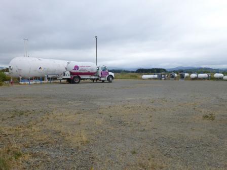 United Chrome Products, Inc.The United Chrome Products, Inc. Superfund site is located just south of Corvallis, Oregon. Owned by the city of Corvallis (the City), the 1.5-acre site is a former industrial hard-chrome plating facility. Non-food grass-seed farming, aviation and light industrial uses surround the site. Past activities contaminated soil and groundwater with chromium and other hazardous waste. EPA placed the site on the National Priorities List (NPL) in 1984. In 1985, EPA removed chromium-contaminated soils and disposed of hazardous waste off site. Groundwater has been pumped and treated to remove contamination. The City continues to pump groundwater and perform long-term groundwater monitoring. CoEnergy leases part of the site for truck parking and propane distribution. The City has constructed a solar array on the western portion of the site.
Last updated September 2019
As of December 2019, EPA had data on one on-site business. EPA did not have further economic details related to this business. For additional information click here.
For more information: