Urbanization - Riparian/Channel Alteration
Riparian/Channel Alteration
- Provide organic matter for stream food webs
- Provide habitat (e.g., woody debris, bank vegetation)
- Reduce bank and channel erosion
- Moderate stream temperatures
- Intercept and process groundwater nutrients and pollutants
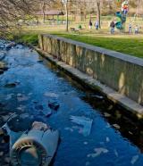
Urbanization typically reduces the extent and quality of riparian areas, via the removal of native vegetation and the development of near-stream areas (see Figure 4).
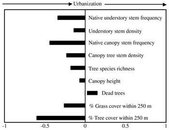 Figure 4. Spearman’s rank correlations between riparian urbanization (building area within 250 m radius of stream site) and riparian vegetation characteristics, at 71 sites near Cincinnati, Ohio. Many of these characteristics (e.g., riparian tree density and cover) showed negative relationships with urbanization.
 From Pennington DN et al. 2008. The conservation value of urban riparian areas for landbirds during spring migration: land cover, scale, and vegetation effects. Biological Conservation 141:1235-1248. Reprinted with permission from Elsevier.
These alterations can contribute to multiple instream stressors, including:
Water/sediment quality: decreased nutrient uptake and retention, increased erosion of bank sediments (and associated contaminants)
Temperature: decreased shading and thermal buffering
Hydrology: decreased woody debris inputs, decreased interception of surface and groundwater flows
Physical habitat: increased erosion of bank sediments, decreased woody debris inputs
Energy sources: decreased leaf inputs, increased algal biomass (due to decreased shading), increased dissolved organic carbon
Direct modification of stream channels is common in urban systems. These direct alterations of channel morphology often are the most damaging changes urban streams experience (see the Physical Habitat module and the Physical Habitat section of this module).
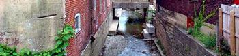 Photo courtesy of Bob Davis, NOAA
- Channelization (i.e., channel straightening)
- Channel hardening or armoring (e.g., lining channels and banks with concrete and riprap)
- Creation of dams and impoundments
- Stream piping and burial
Riparian Zones and Channel Morphology
Forested riparian zones play a key role in determining stream channel morphology. Their root structures can help stabilize streambanks, and the woody debris they contribute to streams can protect banks by absorbing flow energy.
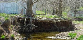 Stream with reduced riparian tree cover and an eroded bank.
Because urbanization often results in riparian alteration, it is difficult to separate the effects of general watershed urbanization (e.g., increased stormflows) on channel morphology from those of riparian alteration. Hession et al. (2003) tackled this issue, using a paired design that considered forested and nonforested riparian reachs on both urban and nonurban streams.
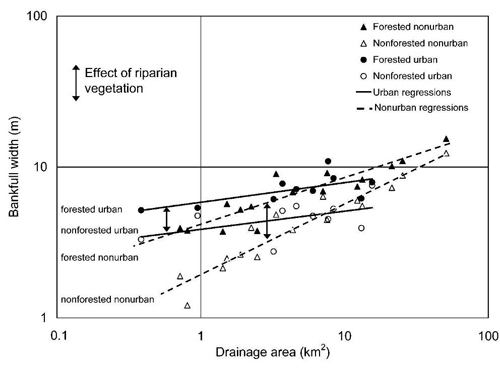 Figure 5. Bankfull width in urban and nonurban streams, with forested and nonforested riparian reaches, as a function of drainage basin area. Vertical arrows indicate the effect of riparian vegetation on bankfull width in urban and nonurban streams.
From Hession WC et al. 2003. Influence of bank vegetation on channel morphology in rural and urban watersheds. Geology 31(2):147-150. Reprinted with permission.They examined the effects of urbanization and riparian vegetation on channel morphology in 26 unchannelized mid-Atlantic streams (Figure 5), and found that:
- Urban streams were generally wider than nonurban streams, especially for smaller streams.
- Forested urban streams were generally wider than nonforested (i.e., grassed) urban streams.
- Differences between forested and nonforested reaches (i.e., the vertical arrows in Figure 5) were generally similar for urban and nonurban streams—illustrating that even in urban systems, riparian vegetation influences channel morphology.
In extrapolating these results to other sites, however, keep in mind that relationships between riparian alteration and channel morphology in urban streams depend upon numerous other factors. These factors include stream size, stream gradient, surrounding geology, and riparian vegetation type.
Urbanization and Riparian Hydrology
Increased stormwater flows associated with urban development can scour stream channels and increase channel incision. This is especially true in systems with limited sediment inputs (e.g., highly impervious watersheds, which often occur in older urban areas).
Channel incision and reduced infiltration (again, due to impervious surfaces) act to lower riparian water tables (see Figure 6), thereby altering riparian hydrology.
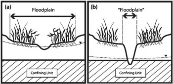 Figure 6. Cross-sectional view of typical groundwater tables (dotted lines) in (a) rural and (b) urban streams underlain by a shallow confining unit.
From Hardison EC et al. 2009. Urban land use, channel incision, and water table decline along Coastal Plain streams, North Carolina. Journal of the American Water Resources Association 45(4):1032-1046. Reprinted with permission.
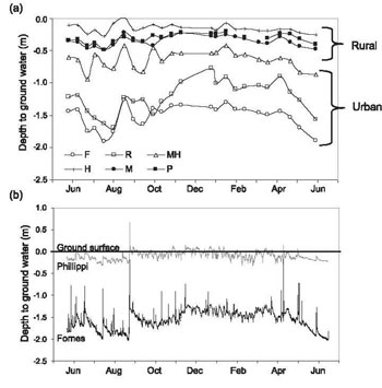 Figure 7. (a) Mean riparian zone groundwater depths, June 2006-June 2007, for six sites varying in catchment impervious area (rural = 3.8-12.4% total impervious area, urban = 22.1-36.7%). (b) Half-hourly riparian zone groundwater depths, over the same period, at the most rural (Phillippi) and most urban (Fornes) sites.
 From Hardison EC et al. 2009. Urban land use, channel incision, and water table decline along Coastal Plain streams, North Carolina. Journal of the American Water Resources Association 45(4):1032-1046. Reprinted with permission.For example, Hardison et al. (2009) examined six Coastal Plain streams in North Carolina, ranging from 3.8-36.7% catchment impervious area. They found that:
- Channel incision increased with total impervious area (TIA).
- The duration of shallow riparian groundwater throughout the year decreased as TIA increased.
- Sites with higher TIA had greater depths to riparian groundwater (Figure 7).
- Shifts in riparian vegetation from wetland to upland species, or from diverse to limited size distributions
- Changes in nitrogen uptake and cycling, such that urban riparian areas may be sources of, rather than sinks for, nitrate
Stream Burial
- Drainage density of natural channels was approximately ⅓ less in urban and suburban vs. forested catchments in Atlanta, GA (Meyer and Wallace 2001).
- Approximately ⅔ of all streams were buried in Baltimore City, MD (Elmore and Kaushal 2008).
- 93% of ephemeral channel length and 46% of intermittent channel length were lost to burial and piping associated with urbanization in Hamilton County, OH (Roy et al. 2009, Figures 8 and 9). As a result, drainage areas for remaining ephemeral and intermittent channels were larger in urban areas.
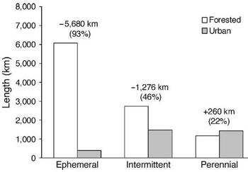 Figure 8. Total ephemeral, intermittent and perennial channel length within Hamilton County, OH for forested vs. urban catchments. Ephemeral streams are channels with distinct stream beds and banks that carry water briefly during and after storms; intermittent streams are channels that carry water during the wet season; perennial streams are channels that carry flow all year. Numbers above bars indicate absolute and % different in channel length between forested and urban catchments.
From Roy AH et al. 2009. Urbanization affects the extent and hydrologic permanence of headwater streams in a midwestern US metropolitan area. Journal of the North American Benthological Society 28(4):911-928. Reprinted with permission.
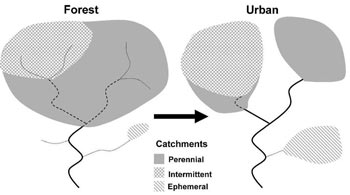 Figure 9. Conceptual representation of how urbanization affects headwater streams in Hamilton County, OH. Dotted lines indicate ephemeral streams, dashed lines indicate intermittent streams, solid lines indicate perennial streams; shading indicates drainage area for each stream type.
 From Roy AH et al. 2009. Urbanization affects the extent and hydrologic permanence of headwater streams in a midwestern US metropolitan area. Journal of the North American Benthological Society 28(4):911-928. Reprinted with permission.
Interestingly, Roy et al. (2009) found that perennial channel length actually increased with urbanization (see Figure 8), although approximately 40% of perennial channels originated from pipes. This increase in perennial channel length was due at least in part to increased baseflow stemming from reductions in forest cover and evapotranspiration.